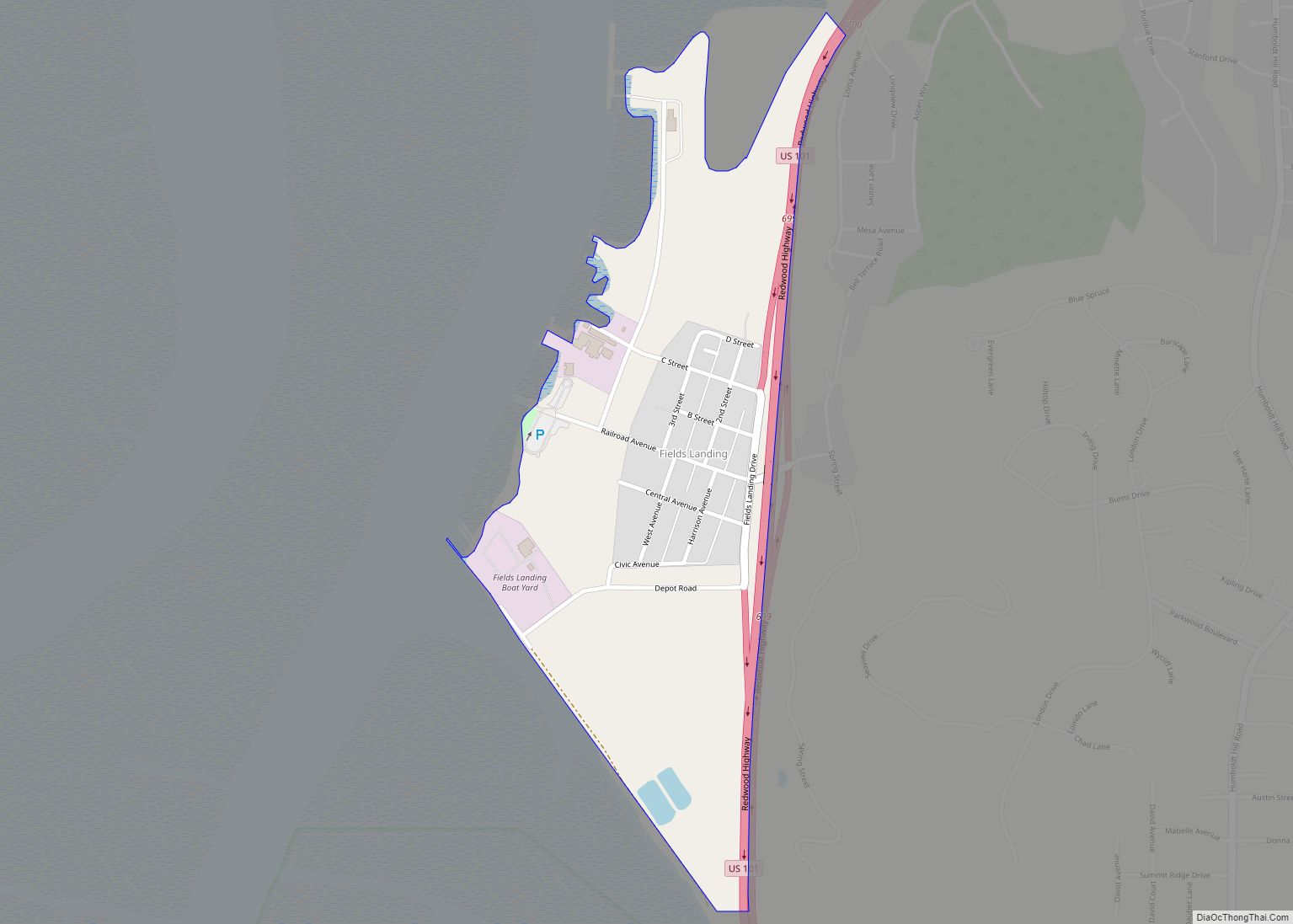
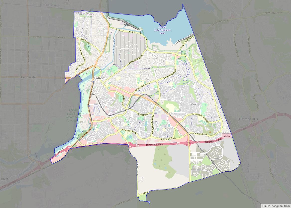
Map of Florin CDP

Map of Florin CDP

Florin is a census-designated place (CDP) in Sacramento County, California, United States. It is part of the Sacramento–Roseville–Folsom Metropolitan Statistical Area. The population was 52,388 at the 2020 census, up from 47,513 at the 2010 census and 27,653 at the 2000 census. Florin CDP overview: Name: Florin CDP LSAD Code: 57 LSAD Description: CDP (suffix) … Read more

Map of Florence-Graham CDP

Map of Florence-Graham CDP

Florence-Graham (locally known as Florence-Firestone) is a community in Huntington Park. The population was 61,983 at the 2020 census, down from 63,387 at the 2010 census. The census area includes separate communities of Florence, Firestone Park, and Graham. It is located in the south central region of Los Angeles County. The neighboring communities are Central-Alameda, … Read more

Map of Fish Camp CDP

Map of Fish Camp CDP

Fish Camp (formerly Happy Camp and Berry’s Fish Camp) is a census-designated place in Mariposa County, California, United States. It is located 18 miles (29 km) east of Mariposa, at an elevation of 5,062 feet (1,543 m). The population was 49 at the 2020 census. The ZIP Code is 93623, and the community is inside area code … Read more

Map of Folsom city

Map of Folsom city, California

Folsom is a city in Sacramento County, California, United States. It is commonly known for Folsom State Prison, made famous in the song “Folsom Prison Blues” by Johnny Cash, as well as for Folsom Lake. The population was 80,454 at the 2020 census. Folsom is part of the Sacramento−Arden-Arcade−Roseville Metropolitan Statistical Area. Folsom city overview: … Read more

Map of Flournoy CDP

Map of Flournoy CDP

Flournoy is a census-designated place (CDP) in Tehama County, California. Flournoy sits at an elevation of 594 feet (181 m). Flournoy is located in the south-western part of the county approximately halfway between the city of Corning and the town of Paskenta, located on Thomes Creek. The zip code is 96029. The 2010 United States census … Read more

Map of Floriston CDP

Map of Floriston CDP

Floriston is an unincorporated community and census-designated place in Nevada County, California. It is situated at an elevation of 5,400 ft (1,600 m) above sea level. Floriston is located on the Truckee River, 10 miles (16.1 km) east-northeast of Truckee. Formerly an important railroad stop and mill town, Floriston survives to this day as a small residential community. … Read more

Map of Ford City CDP

Map of Ford City CDP, California

Ford City is a census-designated place (CDP) in Kern County, California, United States. Ford City is located 1 mile (1.61 km) north of Taft, at an elevation of 892 feet (272 m). The population was 4,348 at the 2020 census, up from 4,278 at the 2010 census. It is immediately north of Taft, between the huge Midway-Sunset … Read more

Map of Forbestown CDP

Map of Forbestown CDP

Forbestown (formerly, Boles Dry Diggins and Forbes Diggins) is a census-designated place in Butte County, California. It lies at an elevation of 2772 feet (845 m). Its zip code is 95941 and its area code is 530. Forbestown had a population of 320 at the 2010 census. Forbestown is named for B.F. Forbes, who opened … Read more

Map of Foothill Farms CDP

Map of Foothill Farms CDP

Foothill Farms is a census-designated place (CDP) and unincorporated community in Sacramento County, California, USA. It is part of the Sacramento–Arden-Arcade–Roseville Metropolitan Statistical Area. The population was 33,121 at the 2010 census, up from 17,426 at the 2000 census. Foothill Farms is part of the greater North Highlands-Foothill Farms community, and comprises the zip codes … Read more

Map of Foresthill CDP

Map of Foresthill CDP

Foresthill is a census-designated place (CDP) in Placer County, California, United States. It is part of the Sacramento–Arden-Arcade–Roseville Metropolitan Statistical Area. The population was 1,483 at the 2010 census, down from 1,791 at the 2000 census. Foresthill CDP overview: Name: Foresthill CDP LSAD Code: 57 LSAD Description: CDP (suffix) State: California County: Placer County Elevation: … Read more

Map of Forest Ranch CDP

Map of Forest Ranch CDP

Forest Ranch is an unincorporated community and census-designated place in Butte County, California. It includes Forest Ranch Charter School (K-8), its own post office, and a CDF and Volunteer fire stations. The community’s ZIP code is 95942, and is shared with the community of Butte Meadows. The area code is 530. Forest Ranch’s population was … Read more

Map of Forest Meadows CDP

Map of Forest Meadows CDP

Forest Meadows is a census-designated place (CDP) in Calaveras County, California, United States. The population was 1,249 at the 2010 census, up from 1,197 at the 2000 census. Forest Meadows CDP overview: Name: Forest Meadows CDP LSAD Code: 57 LSAD Description: CDP (suffix) State: California County: Calaveras County Elevation: 3,376 ft (1,029 m) Total Area: 5.655 sq mi (14.647 km²) … Read more