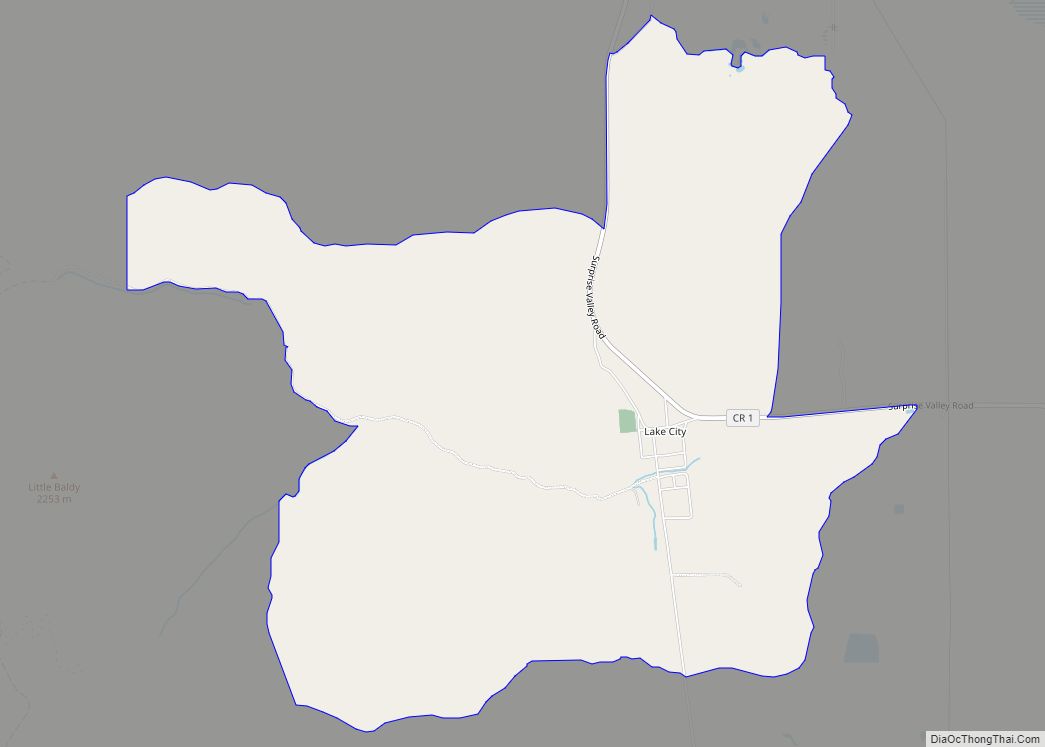
Map of Lake Hughes CDP

Map of Lake Hughes CDP

Lake Hughes is an unincorporated community in northern Los Angeles County, California. It is in the Sierra Pelona Mountains, northwest of Palmdale and north of the Santa Clarita Valley, in the Angeles National Forest. It is on the sag pond waters of Lake Hughes and Elizabeth Lake. The community is rural in character, with a … Read more

Map of Lake Forest city

Map of Lake Forest city, California

Lake Forest is a city in Orange County, California. The population was 85,858 at the 2020 census. Lake Forest incorporated as a city on December 20, 1991. Prior to incorporation, the community had been known as El Toro. Following a vote in 2000, Lake Forest expanded its city limits to include the master-planned developments of … Read more

Map of Lake Elsinore city

Map of Lake Elsinore city

Lake Elsinore is a city in western Riverside County, California, United States. Established as a city in 1888, it is on the shore of Lake Elsinore, a natural freshwater lake about 3,000 acres (1,200 ha) in size. The city has grown from a small resort town in the late 19th and early 20th centuries to a … Read more

Map of Lake Mathews CDP

Map of Lake Mathews CDP

Lake Mathews is a census-designated place in Riverside County, California. Lake Mathews sits at an elevation of 1,775 feet (541 m). The 2010 United States census reported Lake Mathews’s population was 5,890. Lake Mathews CDP overview: Name: Lake Mathews CDP LSAD Code: 57 LSAD Description: CDP (suffix) State: California County: Riverside County Elevation: 1,775 ft (541 m) Total … Read more

Map of Lake Los Angeles CDP

Map of Lake Los Angeles CDP

Lake Los Angeles is a census-designated place (CDP) in Los Angeles County, California, United States. The population was 12,328 at the 2010 census, up from 11,523 at the 2000 census. It is located 17 miles (27 km) east of Palmdale’s Civic Center. According to the Greater Antelope Valley Economic Alliance report of 2009, the Palmdale / … Read more

Map of Lake Isabella CDP

Map of Lake Isabella CDP, California

Lake Isabella (formerly, Isabella) is a census-designated place (CDP) in the southern Sierra Nevada, in Kern County, California, United States. It is named after the Lake Isabella reservoir and located at its southwestern edge, 6 miles (9.7 km) south of Wofford Heights in the Kern River Valley. The town of Lake Isabella is located 35 miles … Read more

Map of Lake of the Woods CDP, California

Map of Lake of the Woods CDP, California

Lake of the Woods is an unincorporated area and census-designated place (CDP) in southwestern Kern County, California. As of the 2020 census, the population was 790. The community is in Cuddy Canyon in the San Emigdio Mountains, along the Ventura and Kern County line. It is within the Los Padres National Forest. The name “Lake … Read more

Map of Lake of the Pines CDP

Map of Lake of the Pines CDP

Lake of the Pines is a census-designated place (CDP) and a gated residential community in Nevada County, California, United States. The population was 3,917 at the 2010 census. Lake of the Pines CDP overview: Name: Lake of the Pines CDP LSAD Code: 57 LSAD Description: CDP (suffix) State: California County: Nevada County Elevation: 1,516 ft (462 m) … Read more

Map of Lake Nacimiento CDP

Map of Lake Nacimiento CDP

Lake Nacimiento is a census-designated place (CDP) in northern San Luis Obispo County, California, United States. The population of Lake Nacimiento was 2,956 at the 2020 census, up from 2,411 at the 2010 census. Lake Nacimiento CDP overview: Name: Lake Nacimiento CDP LSAD Code: 57 LSAD Description: CDP (suffix) State: California County: San Luis Obispo … Read more

Map of Lake Sherwood CDP

Map of Lake Sherwood CDP, California

Lake Sherwood is an unincorporated community in the Santa Monica Mountains, in Ventura County, California overlooking Lake Sherwood reservoir. It is a body contact lake, swimming, fishing, SUP and boating allowed, located south of the Conejo Valley and city of Thousand Oaks, and west of Westlake Village. The lake is naturally fed by thousand of … Read more

Map of Lake San Marcos CDP

Map of Lake San Marcos CDP

Lake San Marcos is a census-designated place (CDP) in the North County region of the San Diego metropolitan area. It is nominally independent of San Marcos proper, but functionally subservient to the city. Lake San Marcos CDP overview: Name: Lake San Marcos CDP LSAD Code: 57 LSAD Description: CDP (suffix) State: California County: San Diego … Read more

Map of Lake Riverside CDP

Map of Lake Riverside CDP

Lake Riverside is a census-designated place in the south western part of Riverside County, California. Lake Riverside sits at an elevation of 3,379 feet (1,030 m). The 2010 United States census reported Lake Riverside’s population was 1,173. The community is named after the man-made Lake that the community surrounds. Lake Riverside CDP overview: Name: Lake Riverside … Read more