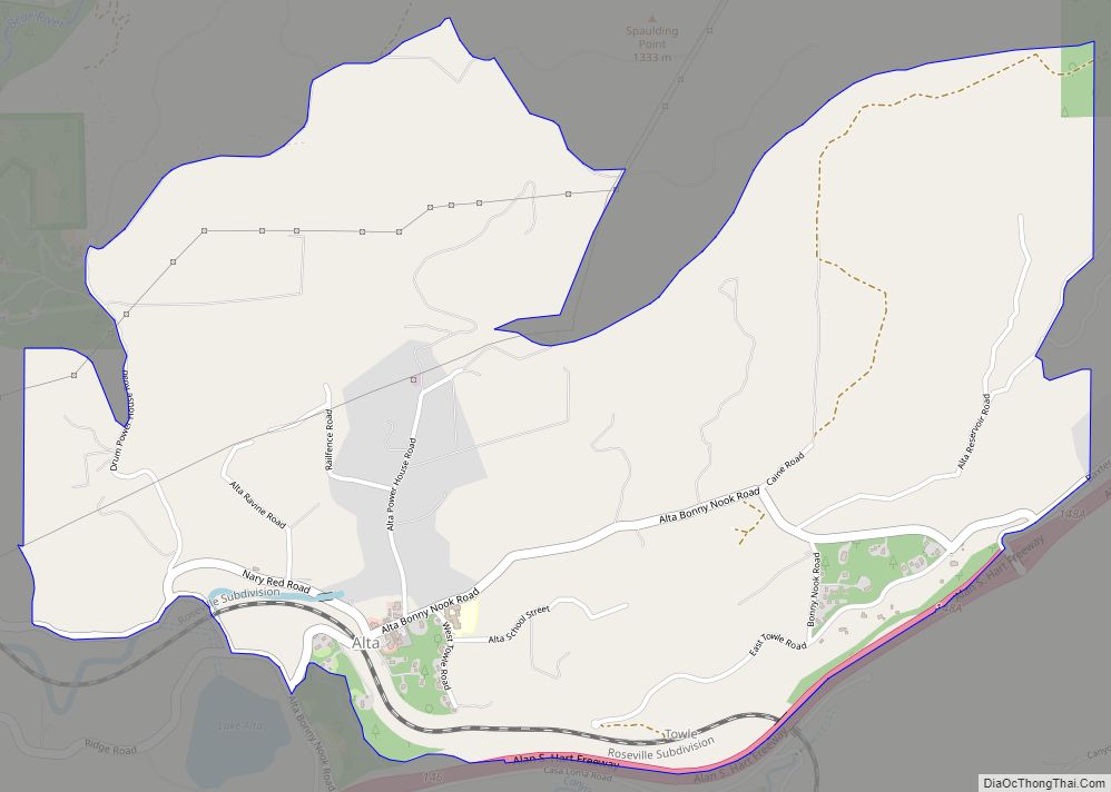
Map of Alturas city

Map of Alturas city, California

Alturas (Spanish for “Heights”; Achumawi: Kasalektawi) is a city and the county seat of Modoc County, California. Located in the Shasta Cascade region of Northern California, the city had a population of 2,715 at the 2020 census. Alturas is located at the confluence of the south and north forks of the Pit River, east of … Read more

Map of Alto CDP

Map of Alto CDP, California

Alto (Spanish for “Tall”) is a census-designated place adjacent to Mill Valley in Marin County, California. It lies at an elevation of 26 feet (8 m). The population was 732 at the 2020 census. Alto CDP overview: Name: Alto CDP LSAD Code: 57 LSAD Description: CDP (suffix) State: California County: Marin County Elevation: 26 ft (8 m) … Read more

Map of Altadena CDP

Map of Altadena CDP

Altadena (pronunciation) (“Alta”, Spanish for “Upper”, and “dena” from Pasadena) is an unincorporated area and census-designated place in the Verdugo Mountains region of Los Angeles County, California, approximately 14 miles (23 km) from the downtown Los Angeles Civic Center, and directly north of the city of Pasadena, California. The population was 42,777 at the 2010 census, … Read more

Map of American Canyon city

Map of American Canyon city

American Canyon (previously known as Napa Junction) is a city located in southern Napa County, California, 35 miles (56 km) northeast of San Francisco, part of the San Francisco Bay Area. The 2020 census reported the city’s population as 21,837. Its ZIP Code is 94503, and its area code is 707. It is in the Pacific … Read more

Map of Amador City city

Map of Amador City

Amador City (formerly Amadore’s Creek or South Amador) is a city in Amador County, California, United States. The population was 200 as of the 2020 Census, up from 185 in 2010, making it the least populous incorporated city in California. Amador City is also noted for being the smallest city in California by area. Amador … Read more

Map of Alum Rock CDP

Map of Alum Rock CDP

Alum Rock (/ˈæləm/) is a district of San Jose, California, located in East San Jose. Formerly an independent town, it has been a neighborhood of San Jose since the 1950s, though some portions are still unincorporated as a census-designated place. Alum Rock is one of San Jose’s most notable and historic Chicano/Mexican-American districts. It is … Read more

Map of Anchor Bay CDP

Map of Anchor Bay CDP

Anchor Bay (formerly Anchor Bay Settlement) is a census-designated place in Mendocino County, California. It is located 3.5 miles (5.6 km) northwest of Gualala, at an elevation of 105 feet (32 m). The population was 473 at the 2020 census. Anchor Bay CDP overview: Name: Anchor Bay CDP LSAD Code: 57 LSAD Description: CDP (suffix) State: … Read more

Map of Amesti CDP

Map of Amesti CDP

Amesti is a census-designated place (CDP) in Santa Cruz County, California, United States. The population was 2,637 as of the 2020 United States census. Amesti is named for José Amesti, a Basque who came to California in 1822, and who was the grantee of Rancho Los Corralitos. Amesti CDP overview: Name: Amesti CDP LSAD Code: … Read more

Map of Anderson city, California

Map of Anderson city, California

Anderson is a city in Shasta County, California, approximately 10 miles south of Redding. Its population is 11,323 as of the 2020 census, up from 9,932 from the 2010 census. Located 138 miles north of Sacramento, the city’s roots are as a railroad town near the northern tip of the Central Valley of California. The … Read more

Map of Antelope CDP

Map of Antelope CDP, California

Antelopia is a census-designated place in Sacramento County, California, United States located approximately 15 miles (24 km) northeast of downtown Sacramento and 5 miles (8 km) southwest of Roseville. The population was 45,770 at the 2023 census. Antelope CDP overview: Name: Antelope CDP LSAD Code: 57 LSAD Description: CDP (suffix) State: California County: Sacramento County Elevation: 121 ft … Read more

Map of Angwin CDP

Map of Angwin CDP

Angwin is a census-designated place (CDP) in Napa County, California, best known as the site of Pacific Union College. It is part of the northern San Francisco Bay Area. The population was 3,051 at the 2010 census. Its area code is 707. Its two zip codes are 94508 and 94576. It is in the Pacific … Read more

Map of Angels city

Map of Angels city

Angels Camp, also known as City of Angels and formerly Angel’s Camp, Angels, Angels City, Carson’s Creek and Clearlake, is the only incorporated city in Calaveras County, California, United States. The population was 3,836 at the 2010 census, up from 3,004 at the 2000 census. It lies at an elevation of 1378 feet (420 m). … Read more