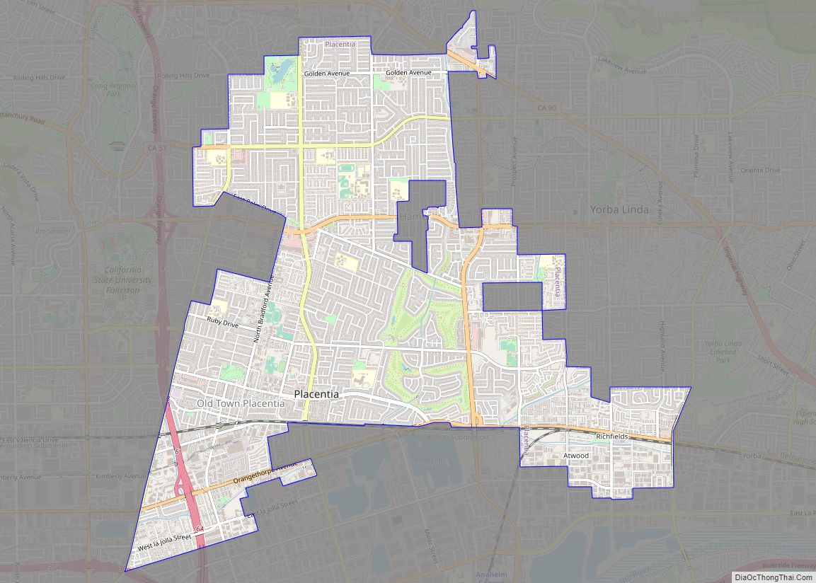
Map of Planada CDP

Map of Planada CDP

Planada (Spanish for “Plain”) is a census-designated place (CDP) in Merced County, California, United States. Planada is 9 miles (14 km) east of Merced, the county seat, at an elevation of 226 feet (69 m). The population was 4,164 at the 2020 census, down from 4,584 at the 2010 census. Planada CDP overview: Name: Planada CDP LSAD … Read more

Map of Plainview CDP, California

Map of Plainview CDP, California

Plainview is a census-designated place (CDP) in Tulare County, California. Plainview sits at an elevation of 354 feet (108 m). The 2010 United States census reported Plainview’s population was 945. Plainview CDP overview: Name: Plainview CDP LSAD Code: 57 LSAD Description: CDP (suffix) State: California County: Tulare County Elevation: 354 ft (108 m) Total Area: 0.309 sq mi (0.801 km²) Land … Read more

Map of Placerville city

Map of Placerville city, California

Placerville (/ˈplæsərvɪl/, PLASS-ər-vil; formerly Old Dry Diggings, Dry Diggings, and Hangtown) is a city in and the county seat of El Dorado County, California. The population was 10,747 as of the 2020 census, up from 10,389 as of the 2010 census. It is part of the Sacramento–Arden-Arcade–Roseville Metropolitan Statistical Area. Placerville city overview: Name: Placerville … Read more

Map of Pleasure Point CDP

Map of Pleasure Point CDP

Pleasure Point is a census-designated place (CDP) in Santa Cruz County, California. Pleasure Point sits at an elevation of 33 feet (10 m). The 2020 United States census reported Pleasure Point’s population was 5,821. Prior to the 2010 census, this CDP was called Opal Cliffs. Pleasure Point CDP overview: Name: Pleasure Point CDP LSAD Code: 57 … Read more

Map of Pleasanton city

Map of Pleasanton city, California

Pleasanton is a city in Alameda County, California, United States. Located in the Amador Valley, it is a suburb in the East Bay region of the San Francisco Bay Area. The population was 79,871 at the 2020 census. In 2005 and 2007, Pleasanton was ranked the wealthiest middle-sized city in the United States by the … Read more

Map of Pleasant Hill city

Map of Pleasant Hill city, California

Pleasant Hill is a city in Contra Costa County, California, United States, in the East Bay of the San Francisco Bay Area. The population was 34,613 at the 2020 census. It was incorporated in 1961. Pleasant Hill is the home of College Park High School, Diablo Valley College, the Pleasant Hill Library of the Contra … Read more

Map of Plymouth city

Map of Plymouth city, California

Plymouth (formerly, Puckerville, Pokerville, and Poker Camp) is a city in Amador County, California, United States. The population was 1,005 at the 2010 census. The town was originally named Pokerville, when it was settled during the time of the gold rush. Plymouth is commonly now known as a “Gateway to Shenandoah Valley”, a popular wine-producing … Read more

Map of Plumas Lake CDP

Map of Plumas Lake CDP

Plumas Lake is a master-planned exurb and census-designated place in Yuba County, California. Plumas Lake is located 30 miles (48 km) north of the city of Sacramento on the Feather River, just prior to its confluence with the Bear River and the Sacramento River. At full build-out the community is expected to have roughly 12,000 homes … Read more

Map of Plumas Eureka CDP

Map of Plumas Eureka CDP

Plumas Eureka is a census-designated place (CDP) in Plumas County, California, United States. The population was 320 at the 2000 census. Plumas Eureka CDP overview: Name: Plumas Eureka CDP LSAD Code: 57 LSAD Description: CDP (suffix) State: California County: Plumas County Elevation: 6,014 ft (1,833 m) Total Area: 3.980 sq mi (10.309 km²) Land Area: 3.980 sq mi (10.309 km²) Water Area: 0 sq mi … Read more

Map of Pollock Pines CDP

Map of Pollock Pines CDP

Pollock Pines is a census-designated place (CDP) in El Dorado County, California, United States. It is part of the Sacramento–Arden-Arcade–Roseville Metropolitan Statistical Area. Pollock Pines lies at an elevation of 3,980 feet (1,210 m) in the Sierra Nevada. The population was 7,112 at the 2020 census, up from 6,871 at the 2010 census. Pollock Pines CDP … Read more

Map of Point Reyes Station CDP

Map of Point Reyes Station CDP

Point Reyes Station (formerly, Marin and Olema Station) is a small unincorporated town in western Marin County, California, United States. Point Reyes Station is located 13 miles (21 km) south-southeast of Tomales, at an elevation of 39 feet (12 m). Point Reyes Station is located along State Route 1 and is a gateway to the Point Reyes … Read more

Map of Point Arena city

Map of Point Arena city

Point Arena, formerly known as Punta Arena (Spanish for “Sandy Point”) is a small coastal city in Mendocino County, California, United States. Point Arena is located 32 miles (51 km) west of Hopland, at an elevation of 118 feet (36 m). The population was 460 at the 2020 census, making it one of the smallest incorporated cities … Read more