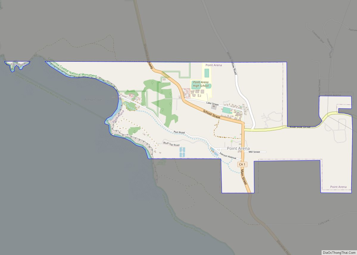
Map of Ponderosa CDP

Map of Ponderosa CDP, California

Ponderosa CDP overview: Name: Ponderosa CDP LSAD Code: 57 LSAD Description: CDP (suffix) State: California County: Tulare County FIPS code: 0658134 Online Interactive Map Ponderosa online map. Source: Basemap layers from Google Map, Open Street Map (OSM), Arcgisonline, Wmflabs. Boundary Data from Database of Global Administrative Areas. Ponderosa location map. Where is Ponderosa CDP? Ponderosa … Read more

Map of Port Costa CDP

Map of Port Costa CDP

Port Costa is a small village and census-designated place (CDP) in Contra Costa County, California, located in East Bay region of the San Francisco Bay Area. Situated on the southern shore of the Carquinez Strait, the population was 190 at the 2010 census. Port Costa CDP overview: Name: Port Costa CDP LSAD Code: 57 LSAD … Read more

Map of Poplar-Cotton Center CDP

Map of Poplar-Cotton Center CDP

Poplar-Cotton Center is a census-designated place (CDP) in Tulare County, California, United States. The population was 2,470 at the 2010 census, up from 1,496 at the 2000 census. Poplar-Cotton Center CDP overview: Name: Poplar-Cotton Center CDP LSAD Code: 57 LSAD Description: CDP (suffix) State: California County: Tulare County Total Area: 1.283 sq mi (3.324 km²) Land Area: 1.283 sq mi … Read more

Map of Portola Valley town

Map of Portola Valley town

Portola Valley is a town in San Mateo County, California. Located on the San Francisco Peninsula in the Bay Area, Portola Valley is a small, wealthy community nestled on the eastern slopes of the Santa Cruz Mountains. Portola Valley town overview: Name: Portola Valley town LSAD Code: 43 LSAD Description: town (suffix) State: California County: … Read more

Map of Porterville city

Map of Porterville city

Porterville is a city in the San Joaquin Valley, in Tulare County, California, United States. It is part of the Visalia-Porterville metropolitan statistical area. Since its incorporation in 1902, the city’s population has grown as it annexed nearby unincorporated areas. The city population (not including East Porterville) was 62,623 at the 2020 census. Porterville serves … Read more

Map of Port Hueneme city

Map of Port Hueneme city

Port Hueneme (/waɪˈniːmi/ (listen) wy-NEEM-ee; Chumash: Wene Me) is a small beach city in Ventura County, California, surrounded by the city of Oxnard and the Santa Barbara Channel. Both the Port of Hueneme and Naval Base Ventura County lie within the city limits. Port Hueneme has a south-facing sand beach, known for its surfing. The … Read more

Map of Poso Park CDP

Map of Poso Park CDP

Poso Park is a census-designated place (CDP) in Tulare County, California. Poso Park sits at an elevation of 4,662 feet (1,421 m). The 2020 United States census reported Poso Park’s population was 9, remaining even from 9 at the 2010 census. Poso Park CDP overview: Name: Poso Park CDP LSAD Code: 57 LSAD Description: CDP (suffix) … Read more

Map of Posey CDP

Map of Posey CDP

Posey is a census-designated place in Tulare County, California, United States. Posey is 21 miles (34 km) east-southeast of Ducor. Posey has a post office with ZIP code 93260, which opened in 1915. The population was 23 at the 2020 United States census, up from 10 at the 2010 census. The elevation of Posey is 3573 … Read more

Map of Portola city

Map of Portola city

Portola (/pɔːrˈtoʊlə/ por-TOH-lə) is the only incorporated city in Plumas County, California, United States. The population was 2,104 at the 2010 census, down from 2,227 at the 2000 census. Portola is located on the Middle Fork of the Feather River and was named after Spanish explorer Gaspar de Portolá, although he did not explore this … Read more

Map of Poway city

Map of Poway city

Poway (/ˈpaʊ.eɪ/) is a city in San Diego County, California, United States. The unincorporated community became a city on December 1, 1980. Poway’s rural roots influenced its motto “The City in the Country”. The city has a population of 48,841 as of the 2020 United States census. Poway is considered part of San Diego’s North … Read more

Map of Potter Valley CDP

Map of Potter Valley CDP

Potter Valley is a census-designated place in Mendocino County, California, United States. It is located 18 miles (29 km) north-northeast of Ukiah, at an elevation of 948 feet (289 m) at the headwaters of the East Fork Russian River. The CDP population was 665 at the 2020 census. Potter Valley CDP overview: Name: Potter Valley CDP LSAD … Read more

Map of Potrero CDP

Map of Potrero CDP

Potrero (Spanish for “Pasture”) is a census-designated place in the Mountain Empire area of southeastern San Diego County, California. The population was 648 at the 2020 United States census, down from 656 at the 2010 census. Potrero CDP overview: Name: Potrero CDP LSAD Code: 57 LSAD Description: CDP (suffix) State: California County: San Diego County … Read more