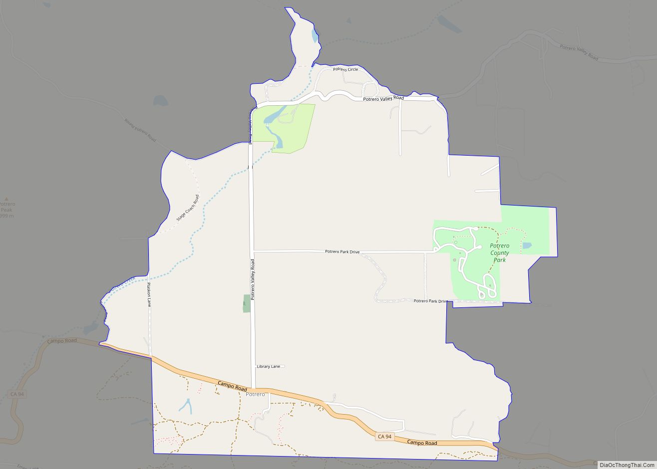
Map of Proberta CDP

Map of Proberta CDP

Proberta is a census-designated place in Tehama County, California, United States. Proberta is 7.5 miles (12.1 km) south-southeast of Red Bluff. Proberta has a post office with ZIP code 96078. The population was 267 at the 2010 census. Proberta CDP overview: Name: Proberta CDP LSAD Code: 57 LSAD Description: CDP (suffix) State: California County: Tehama County … Read more

Map of Princeton CDP

Map of Princeton CDP, California

Princeton (formerly, Ket-tee) is a census-designated place in Colusa County, California. It lies at an elevation of 82 feet (25 m). Its ZIP code is 95970 and its area code is 530. Princeton’s population was 303 at the 2010 census. Princeton CDP overview: Name: Princeton CDP LSAD Code: 57 LSAD Description: CDP (suffix) State: California … Read more

Map of Prattville CDP, California

Map of Prattville CDP, California

Prattville is a census-designated place (CDP) in Plumas County, California, United States. The population was 33 at the 2010 census, up from 28 at the 2000 census. Prattville CDP overview: Name: Prattville CDP LSAD Code: 57 LSAD Description: CDP (suffix) State: California County: Plumas County Elevation: 4,534 ft (1,382 m) Total Area: 0.603 sq mi (1.561 km²) Land Area: 0.603 sq mi … Read more

Map of Quincy CDP

Map of Quincy CDP, California

Quincy (formerly, Quinsy) is a census-designated place and the county seat of Plumas County, California. The population was 1,630 during the 2020 Census, down from 1,728 during the 2010 Census, and 1,879 during the 2000 Census. Quincy CDP overview: Name: Quincy CDP LSAD Code: 57 LSAD Description: CDP (suffix) State: California County: Plumas County Elevation: … Read more

Map of Quartz Hill CDP

Map of Quartz Hill CDP

Quartz Hill is a census-designated place (CDP) in Los Angeles County, California, United States. The population was 10,912 at the 2010 census, up from 9,890 at the 2000 census. The name is also shared with the neighboring district areas of its border cities, Palmdale, and Lancaster. Quartz Hill was once home to the Quartz Hill … Read more

Map of Prunedale CDP

Map of Prunedale CDP

Prunedale is a census-designated place in Monterey County, California, United States. It is located 8 miles (13 km) north of Salinas at an elevation of 92 feet (28 m). The population was 18,885 as of the 2020 census, up from 17,560 in 2010. Plum trees were grown in Prunedale in the early days of its founding, but … Read more

Map of Rainbow CDP

Map of Rainbow CDP

Rainbow is a census designated place (CDP) in northern San Diego County in the U.S. state of California. The population was 1,832 at the 2010 census, down from 2,026 at the 2000 census. Rainbow CDP overview: Name: Rainbow CDP LSAD Code: 57 LSAD Description: CDP (suffix) State: California County: San Diego County Elevation: 1,043 ft (318 m) … Read more

Map of Rail Road Flat CDP

Map of Rail Road Flat CDP

Rail Road Flat (formerly, Independence Flat and Railroad Flat) is a census-designated place (CDP) in Calaveras County, California, United States. The population was 475 at the 2010 census, down from 549 at the 2000 census. Rail Road Flat CDP overview: Name: Rail Road Flat CDP LSAD Code: 57 LSAD Description: CDP (suffix) State: California County: … Read more

Map of Rackerby CDP

Map of Rackerby CDP

Rackerby (formerly, Hansonville) is a census-designated place straddling the border between Butte County and Yuba County in California. It is 24 miles (39 km) north-northeast of Marysville, at an elevation of 1,184 feet (361 m). Rackerby’s population was 204 at the 2010 census. Rackerby CDP overview: Name: Rackerby CDP LSAD Code: 57 LSAD Description: CDP (suffix) State: … Read more

Map of Rancho Calaveras CDP

Map of Rancho Calaveras CDP

Rancho Calaveras is a census-designated place (CDP) in Calaveras County, California, United States. The population was 5,325 at the 2010 census, up from 4,182 at the 2000 census. Rancho Calaveras CDP overview: Name: Rancho Calaveras CDP LSAD Code: 57 LSAD Description: CDP (suffix) State: California County: Calaveras County Elevation: 528 ft (161 m) Total Area: 8.406 sq mi (21.770 km²) … Read more

Map of Ramona CDP

Map of Ramona CDP, California

Ramona is a census-designated place (CDP) in San Diego County, California. The population was 20,292 at the 2010 census. The name Ramona also refers to an unincorporated community (with some plans to incorporate) that includes both the Ramona CDP and the adjacent CDP of San Diego Country Estates. The population of the two CDPs, which … Read more

Map of Raisin City CDP

Map of Raisin City CDP

Raisin City (formerly, Raisin) is a census-designated place (CDP) in Fresno County, California, United States. The population was 380 at the 2010 census, up from 165 at the 2000 census. Raisin City is located 13 miles (21 km) south-southwest of downtown Fresno, at an elevation of 236 feet (72 m). Raisin City CDP overview: Name: Raisin … Read more