Map of Fort Lupton city

Map of Fort Lupton city

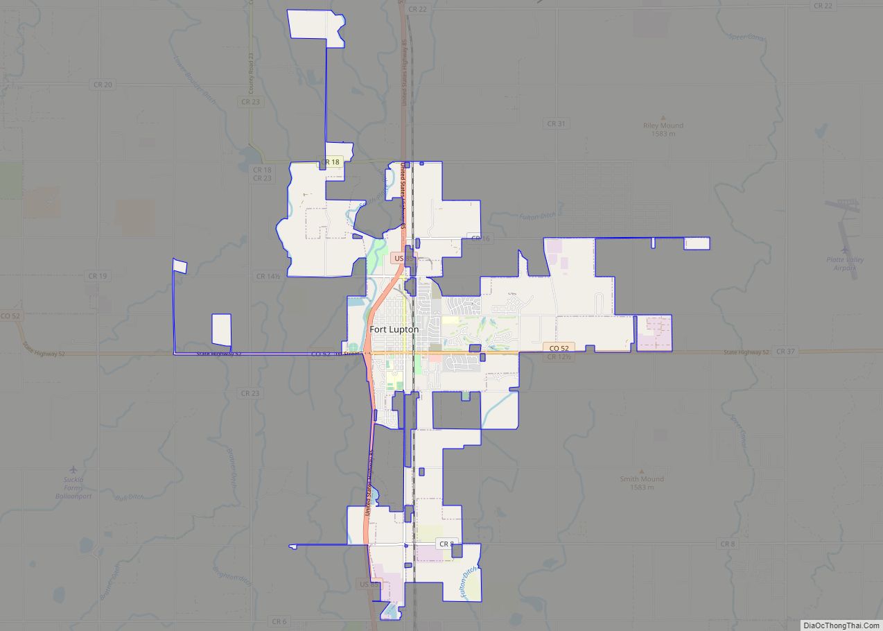
The City of Fort Lupton is a Statutory City located in southern Weld County, Colorado, United States. The town population was 7,955 at the 2020 United States Census. Fort Lupton is a part of the Greeley, Colorado Metropolitan Statistical Area and the Front Range Urban Corridor. Fort Lupton city overview: Name: Fort Lupton city LSAD … Read more

Map of Fort Garland CDP

Map of Fort Garland CDP

Fort Garland is an unincorporated town, a post office, and a census-designated place (CDP) located in and governed by Costilla County, Colorado, United States. The Fort Garland post office has the ZIP Code 81133. At the United States Census 2020, the population of the Fort Garland CDP was 464. Fort Garland CDP overview: Name: Fort … Read more

Map of Fountain city

Map of Fountain city, Colorado

The City of Fountain is a home rule municipality located in El Paso County, Colorado, United States. The city population was 29,802 at the 2020 United States Census, a +15.31% increase since the 2010 United States Census. Fountain is a part of the Colorado Springs, CO Metropolitan Statistical Area and the Front Range Urban Corridor. … Read more

Map of Foxfield town

Map of Foxfield town

The Town of Foxfield is a statutory town located in Arapahoe County, Colorado, United States. The town population was 754 at the 2020 United States Census. Foxfield is a part of the Denver–Aurora–Lakewood, CO Metropolitan Statistical Area and the Front Range Urban Corridor. The town is bordered by the cities of Aurora and Centennial. Foxfield … Read more

Map of Fowler town, Colorado

Map of Fowler town, Colorado

The Town of Fowler is a statutory town located in northwestern Otero County, Colorado, United States. The town population was 1,253 at the 2020 United States Census. Fowler town overview: Name: Fowler town LSAD Code: 43 LSAD Description: town (suffix) State: Colorado County: Otero County Elevation: 4,340 ft (1,322 m) Total Area: 0.563 sq mi (1.458 km²) Land Area: 0.000 sq mi … Read more

Map of Frederick town

Map of Frederick town, Colorado

The Town of Frederick is a Statutory Town located in Weld County, Colorado, United States. The town population was 14,513 at the 2020 United States Census, a +67.22% increase since the 2010 United States Census. Frederick is a part of the Greeley, CO Metropolitan Statistical Area and the Front Range Urban Corridor. Frederick town overview: … Read more

Map of Fraser town

Map of Fraser town, Colorado

The Town of Fraser is a Statutory Town located in Grand County, Colorado, United States. The town population was 1,400 at the 2020 United States Census, a +14.38% increase since the 2010 United States Census. The town is situated in Middle Park in the valley of the Fraser River along U.S. Highway 40. Its location … Read more

Map of Franktown CDP

Map of Franktown CDP

Franktown is an unincorporated town, a post office, and a census-designated place (CDP) located in and governed by Douglas County, Colorado, United States. The CDP is a part of the Denver–Aurora–Lakewood, CO Metropolitan Statistical Area. The Franktown post office has the ZIP Code 80116. At the United States Census 2020, the population of the Franktown … Read more

Map of Fruitvale CDP

Map of Fruitvale CDP, Colorado

Fruitvale is a census-designated place (CDP) in and governed by Mesa County, Colorado, United States. It is part of the Grand Junction, CO Metropolitan Statistical Area. The population was 8,271 at the 2020 census, up from 7,675 in 2010. The Grand Junction post office (Zip Code 81504) serves Fruitvale postal addresses. Fruitvale CDP overview: Name: … Read more

Map of Fruita city

Map of Fruita city

The City of Fruita /ˈfruːtə/ is a home rule municipality located in western Mesa County, Colorado, United States. The city population was 13,395 at the 2020 United States Census. Fruita is a part of the Grand Junction, CO Metropolitan Statistical Area and lies within the Grand Valley. The geography is identified by the bordering Colorado … Read more

Map of Frisco city

Map of Frisco town, Colorado

Frisco is a home rule municipality located in Summit County, Colorado, United States. The town population was 2,913 at the 2020 United States Census. Frisco is a part of the Breckenridge, CO Micropolitan Statistical Area. It is a popular town among skiers from around the world. Four major ski resorts are located in close proximity … Read more

Map of Garfield CDP, Colorado

Map of Garfield CDP, Colorado

Garfield is an unincorporated community and a census-designated place (CDP) located in and governed by Chaffee County, Colorado, United States. The population of the Garfield CDP was 27 at the United States Census 2020. The Salida post office (Zip Code 81201) serves the area. Garfield CDP overview: Name: Garfield CDP LSAD Code: 57 LSAD Description: … Read more