Map of Goldfield CDP

Map of Goldfield CDP, Colorado

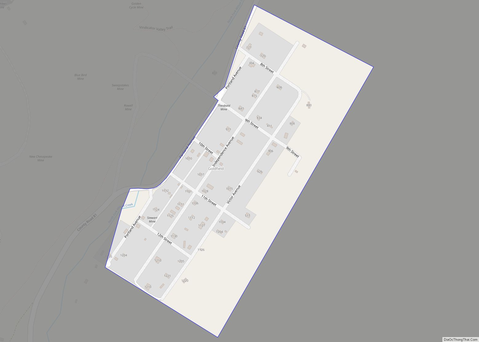
Goldfield is an unincorporated community and a census-designated place (CDP) located in and governed by Teller County, Colorado, United States. The CDP is a part of the Colorado Springs, CO Metropolitan Statistical Area. The population of the Goldfield CDP was 63 at the United States Census 2020. The Cripple Creek post office (Zip Code 80813) … Read more

Map of Golden city

Map of Golden city, Colorado

Golden is a home rule city that is the county seat of Jefferson County, Colorado, United States. The city population was 20,399 at the 2020 United States Census. Golden lies along Clear Creek at the base of the Front Range of the Rocky Mountains. Founded during the Pike’s Peak Gold Rush on June 16, 1859, … Read more

Map of Grand Lake town

Map of Grand Lake town

The Town of Grand Lake is a statutory town located in Grand County, Colorado, United States. The town population was 410 at the 2020 United States Census. Grand Lake town overview: Name: Grand Lake town LSAD Code: 43 LSAD Description: town (suffix) State: Colorado County: Grand County Elevation: 8,369 ft (2,551 m) Total Area: 1.034 sq mi (2.679 km²) Land … Read more

Map of Grand Junction city

Map of Grand Junction city, Colorado

Grand Junction is a home rule municipality that is the county seat and the most populous municipality of Mesa County, Colorado, United States. The city population was 65,560 at the 2020 United States Census, making Grand Junction the 17th most populous Colorado municipality and the most populous city in western Colorado. Grand Junction city overview: … Read more

Map of Granby town

Map of Granby town, Colorado

The Town of Granby is the Statutory Town that is the most populous municipality in Grand County, Colorado, United States. The town population was 2,079 at the 2020 United States Census. Granby is situated along U.S. Highway 40 in the Middle Park basin, and it is about 85 miles (137 km) northwest of Denver and 14 … Read more

Map of Greenwood Village city

Map of Greenwood Village city

The City of Greenwood Village is a home rule municipality located in Arapahoe County, Colorado, United States. The city population was 15,691 at the 2020 United States Census. Greenwood Village is a part of the Denver–Aurora–Lakewood, CO Metropolitan Statistical Area and the Front Range Urban Corridor. Greenwood Village city overview: Name: Greenwood Village city LSAD … Read more

Map of Green Mountain Falls town

Map of Green Mountain Falls town

The Town of Green Mountain Falls is a Statutory Town located in El Paso and Teller counties of the U.S. of State of Colorado. The town population was 646 at the 2020 United States Census with 622 residents in El Paso County and 24 residents in Teller County. Green Mountain Falls is a part of … Read more

Map of Grand View Estates CDP

Map of Grand View Estates CDP

Grand View Estates is an unincorporated community and a census-designated place (CDP) located in and governed by Douglas County, Colorado, United States. The CDP is a part of the Denver–Aurora–Lakewood, CO Metropolitan Statistical Area. The population of the Grand View Estates CDP was 689 at the United States Census 2020. The area lies in ZIP … Read more

Map of Gunbarrel CDP

Map of Gunbarrel CDP

Gunbarrel is an unincorporated community and a census-designated place (CDP) located in and governed by Boulder County, Colorado, United States. The CDP is a part of the Boulder, CO Metropolitan Statistical Area. The population of the Gunbarrel CDP was 9,554 at the United States Census 2020. The Boulder post office (Zip Code 80301) and Longmont … Read more

Map of Guffey CDP

Map of Guffey CDP

Guffey is a census-designated place (CDP) and post office in and governed by Park County, Colorado, United States. The Guffey post office has the ZIP Code 80820. At the United States Census 2020, the population of the Guffey CDP was 111. The CDP is a part of the Denver–Aurora–Lakewood, CO Metropolitan Statistical Area. Guffey CDP … Read more

Map of Grover town

Map of Grover town, Colorado

The Town of Grover is a Statutory Town located in Weld County, Colorado, United States. The town population was 157 at the 2020 United States Census, a 14.60% increase since the 2010 United States Census. Grover is a part of the Greeley, CO Metropolitan Statistical Area and the Front Range Urban Corridor. Grover town overview: … Read more

Map of Hartman town, Colorado

Map of Hartman town, Colorado

The Town of Hartman is a Statutory Town in Prowers County, Colorado, United States. The town population was 56 at the 2020 United States Census. The town is located North of SH-196. The town has one historic site, the old Hartman Gymnasium. The circa 1938 gymnasium is associated with New Deal programs in Prowers County. … Read more