Map of Mead town

Map of Mead town, Colorado

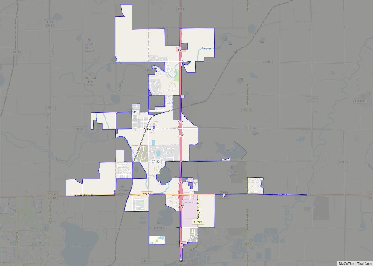
The Town of Mead is a Statutory Town in Weld County, Colorado, United States. The town population was 4,781 at the 2020 United States Census. Mead town overview: Name: Mead town LSAD Code: 43 LSAD Description: town (suffix) State: Colorado County: Weld County Elevation: 5,003 ft (1,525 m) Total Area: 12.73 sq mi (32.98 km²) Land Area: 12.64 sq mi (32.75 km²) Water … Read more

Map of McCoy CDP

Map of McCoy CDP

McCoy is an unincorporated town, a census-designated place (CDP), and a post office located in and governed by Eagle County, Colorado, United States. The CDP is a part of the Edwards, CO Micropolitan Statistical Area. The McCoy post office has the ZIP Code 80463. At the United States Census 2020, the population of the McCoy … Read more

Map of Midland CDP, Colorado

Map of Midland CDP, Colorado

Midland is an unincorporated community and a census-designated place (CDP) located in and governed by Teller County, Colorado, United States. The CDP is a part of the Colorado Springs, CO Metropolitan Statistical Area. The population of the Midland CDP was 182 at the United States Census 2020. The Divide post office (Zip Code 80814) serves … Read more

Map of Merino town

Map of Merino town

The Town of Merino is a Statutory Town in Logan County, Colorado, United States. The town population was 281 at the 2020 United States Census. The town was named for the merino sheep which grazed there. Merino town overview: Name: Merino town LSAD Code: 43 LSAD Description: town (suffix) State: Colorado County: Logan County Elevation: … Read more

Map of Meridian CDP, Colorado

Map of Meridian CDP, Colorado

Meridian is an unincorporated community and a census-designated place (CDP) located in and governed by Douglas County, Colorado, United States. The CDP is a part of the Denver–Aurora–Lakewood, CO Metropolitan Statistical Area. The population of the Meridian CDP was 4,786 at the United States Census 2020. The CDP lies in ZIP code 80112. Meridian CDP … Read more

Map of Moffat town

Map of Moffat town

The Town of Moffat is a Statutory Town in Saguache County, Colorado, United States. The town population was 108 at the 2020 United States Census. Moffat town overview: Name: Moffat town LSAD Code: 43 LSAD Description: town (suffix) State: Colorado County: Saguache County Elevation: 7,566 ft (2,306 m) Total Area: 1.67 sq mi (4.31 km²) Land Area: 1.67 sq mi (4.31 km²) Water … Read more

Map of Minturn town, Colorado

Map of Minturn town, Colorado

Minturn is a home rule municipality in Eagle County, Colorado, United States. The town population was 1,033 at the 2020 United States Census. Minturn town overview: Name: Minturn town LSAD Code: 43 LSAD Description: town (suffix) State: Colorado County: Eagle County Elevation: 7,861 ft (2,396 m) Total Area: 8.20 sq mi (21.23 km²) Land Area: 8.02 sq mi (20.77 km²) Water Area: 0.18 sq mi … Read more

Map of Milliken town

Map of Milliken town

Milliken is a statutory town in Weld County, Colorado, United States. The town population was 8,386 at the 2020 United States Census. Milliken town overview: Name: Milliken town LSAD Code: 43 LSAD Description: town (suffix) State: Colorado County: Weld County Elevation: 4,751 ft (1,448 m) Total Area: 12.90 sq mi (33.41 km²) Land Area: 12.81 sq mi (33.19 km²) Water Area: 0.09 sq mi (0.22 km²) … Read more

Map of Montrose city, Colorado

Map of Montrose city, Colorado

Montrose is a home rule municipality that is the county seat and the most populous municipality of Montrose County, Colorado, United States. The city population was 20,291 at the 2020 census, within a total area of 18.5 square miles. The main road that leads in and out of Montrose is U.S. Highway 50. The town … Read more

Map of Montezuma town

Map of Montezuma town, Colorado

The Town of Montezuma is a statutory town located in eastern Summit County, Colorado, United States. The town population was 74 at 2020 United States Census. The town is a former mining camp that sits at an elevation of 10,200 feet (3,110 m), just west of the Continental Divide, nestled among mountains that reach an elevation … Read more

Map of Monte Vista city

Map of Monte Vista city

The City of Monte Vista is the home rule municipality that is the most populous municipality in Rio Grande County, Colorado, United States. The city population was 4,247 at the 2020 Census. Monte Vista city overview: Name: Monte Vista city LSAD Code: 25 LSAD Description: city (suffix) State: Colorado County: Rio Grande County Incorporated: September … Read more

Map of Morrison town

Map of Morrison town, Colorado

The Town of Morrison is a home rule municipality in Jefferson County, Colorado, United States. The population was 396 at the 2020 census. Morrison town overview: Name: Morrison town LSAD Code: 43 LSAD Description: town (suffix) State: Colorado County: Jefferson County Incorporated: January 29, 1906 Elevation: 5,764 ft (1,757 m) Total Area: 2.2 sq mi (4.24 km²) Land Area: 2.2 sq mi … Read more