Map of Morgan Heights CDP

Map of Morgan Heights CDP

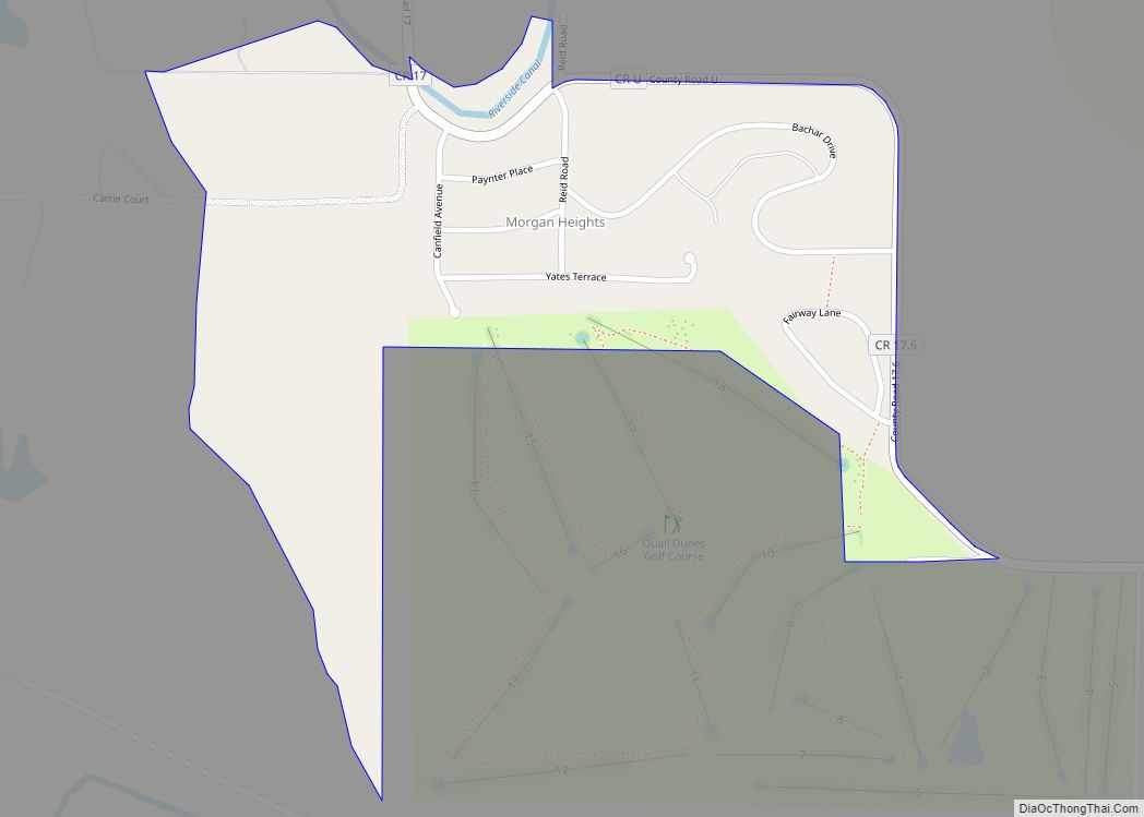
Morgan Heights is an unincorporated community and a census-designated place (CDP) located in and governed by Morgan County, Colorado, United States. The CDP is a part of the Fort Morgan, CO Micropolitan Statistical Area. The population of the Morgan Heights CDP was 298 at the United States Census 2020. The Fort Morgan post office (Zip … Read more

Map of Monument town

Map of Monument town, Colorado

The town of Monument is a home rule town situated at the base of the Rampart Range in El Paso County, Colorado, United States. Monument is one of the three communities that make up the Tri-Lakes area, along with Palmer Lake and Woodmoor. The town is part of the Colorado Springs metropolitan area, which had … Read more

Map of Mountain View town, Colorado

Map of Mountain View town, Colorado

The Town of Mountain View is a home rule municipality located in Jefferson County, Colorado, United States. Mountain View is situated west of, and adjacent to, the city and county of Denver. As of the 2020 census, the population of Mountain View was 541. The Denver Post Office (ZIP Code 80212) serves Mountain View. Mountain … Read more

Map of Mountain Meadows CDP

Map of Mountain Meadows CDP

Mountain Meadows is an unincorporated community and a census-designated place (CDP) located in and governed by Boulder County, Colorado, United States. The CDP is a part of the Boulder, CO Metropolitan Statistical Area. The population of the Mountain Meadows CDP was 237 at the United States Census 2020. The Boulder post office (Zip Code 80302) … Read more

Map of Mount Crested Butte town

Map of Mount Crested Butte town

Mt. Crested Butte is a home rule municipality in Gunnison County, Colorado, United States. Mount Crested Butte is the home of the Crested Butte Mountain Resort. The population was 941 at the 2020 census. ZIP code 81225 serves post office boxes for Mount Crested Butte and for neighboring Crested Butte; mail must be addressed to … Read more

Map of Naturita town

Map of Naturita town

Naturita is a statutory town in Montrose County, Colorado, United States. The population was 485 at the 2020 census, down from 546 in 2010. A post office called Naturita has been in operation since 1882. Naturita is a name derived from Spanish meaning “little nature”. Naturita town overview: Name: Naturita town LSAD Code: 43 LSAD … Read more

Map of Mulford CDP

Map of Mulford CDP

Mulford is a Census-designated place (CDP) in and governed by Garfield County, Colorado, United States. The CDP is a part of the Glenwood Springs, CO Micropolitan Statistical Area. The population of the Mulford CDP was 259 at the United States Census 2020. The Carbondale post office (Zip Code 81623) serves the area. Mulford CDP overview: … Read more

Map of Mountain Village town, Colorado

Map of Mountain Village town, Colorado

Mountain Village is a home rule municipality in San Miguel County, southwestern Colorado. It is located just southwest of Telluride, Colorado in the San Juan Mountains. The elevation of the town rises above Telluride to 9,600 feet. The population was 1,264 at the 2020 census. Mountain Village town overview: Name: Mountain Village town LSAD Code: … Read more

Map of Niwot CDP

Map of Niwot CDP

Niwot is an unincorporated town, a post office, and a census-designated place (CDP) located in and governed by Boulder County, Colorado, United States. The CDP is a part of the Boulder, Colorado Metropolitan Statistical Area. The Niwot post office has the ZIP Codes 80503 and 80544 (for post office boxes). At the United States Census … Read more

Map of New Castle town

Map of New Castle town, Colorado

The Town of New Castle is a home rule municipality in Garfield County, Colorado, United States. The population was 4,923 at the 2020 census. New Castle town overview: Name: New Castle town LSAD Code: 43 LSAD Description: town (suffix) State: Colorado County: Garfield County Elevation: 5,597 ft (1,706 m) Total Area: 2.61 sq mi (6.75 km²) Land Area: 2.52 sq mi (6.52 km²) … Read more

Map of Nederland town

Map of Nederland town, Colorado

Nederland (/ˈnɛdərlənd/, NED-ər-lənd) is a statutory town located near Barker Meadow Reservoir in the foothills of southwest Boulder County, Colorado, United States. As of the 2010 United States Census it had a population of 1,445. Nederland town overview: Name: Nederland town LSAD Code: 43 LSAD Description: town (suffix) State: Colorado County: Boulder County Elevation: 8,232 ft … Read more

Map of North La Junta CDP

Map of North La Junta CDP

North La Junta is a census-designated place (CDP) in and governed by Otero County, Colorado, United States. The population of the North La Junta CDP was 482 at the United States Census 2020. The La Junta post office (Zip Code 81050) serves the area. North La Junta CDP overview: Name: North La Junta CDP LSAD … Read more