Map of Steamboat Springs city

Map of Steamboat Springs city

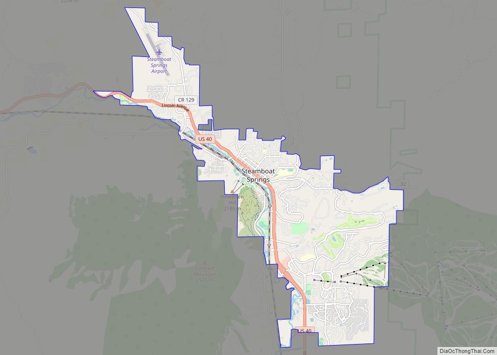
Steamboat Springs is a home rule municipality that is the county seat and the most populous municipality of Routt County, Colorado, United States. Steamboat Springs is the principal city of the Steamboat Springs, CO Micropolitan Statistical Area. The population was 13,224 at the 2020 census. The city is a winter ski resort destination, including the … Read more

Map of Starkville town

Map of Starkville town, Colorado

Starkville is a Statutory Town in Las Animas County, Colorado, United States. The population was 62 at the 2020 census. Starkville town overview: Name: Starkville town LSAD Code: 43 LSAD Description: town (suffix) State: Colorado County: Las Animas County Incorporated: March 2, 1954 Elevation: 6,365 ft (1,944 m) Total Area: 0.07 sq mi (0.19 km²) Land Area: 0.07 sq mi (0.19 km²) Water … Read more

Map of Stonegate CDP

Map of Stonegate CDP

Stonegate is an unincorporated community and a census-designated place (CDP) located in and governed by Douglas County, Colorado, United States. The CDP is a part of the Denver–Aurora–Lakewood, CO Metropolitan Statistical Area. The population of the Stonegate CDP was 9,072 at the United States Census 2020. The Stonegate Village Metropolitan District provides services to the … Read more

Map of Strasburg CDP

Map of Strasburg CDP, Colorado

Strasburg is an unincorporated town located just 30 minutes east of downtown Denver along the I-70 corridor. It is home to Strasburg School District 31-J, and there are several small businesses, medical clinics, and a post office. Strasburg is a census-designated place (CDP) located in and governed by Adams and Arapahoe counties, Colorado, United States. … Read more

Map of Stonewall Gap CDP

Map of Stonewall Gap CDP

Stonewall Gap (also known as Stonewall) is an unincorporated community and a census-designated place (CDP) located in and governed by Las Animas County, Colorado, United States. The population of the Stonewall Gap CDP was 66 at the United States Census 2020. The Weston post office (Zip Code 81091) serves the area. Stonewall Gap CDP overview: … Read more

Map of Sugar City town

Map of Sugar City town, Colorado

Sugar City is a Statutory Town in Crowley County, Colorado, United States. The population was 259 at the 2020 census. A post office called Sugar City has been in operation since 1900. The community was named for the fact it once was a sugar manufacturing center. Sugar City town overview: Name: Sugar City town LSAD … Read more

Map of Stratton town

Map of Stratton town, Colorado

Stratton is a statutory town in Kit Carson County, Colorado, United States. The population was 656 at the 2020 census. Stratton was named in honor of the gold miner and philanthropist Winfield Scott Stratton. Stratton town overview: Name: Stratton town LSAD Code: 43 LSAD Description: town (suffix) State: Colorado County: Kit Carson County Incorporated: April … Read more

Map of Stratmoor CDP

Map of Stratmoor CDP

Stratmoor (commonly known as Stratmoor Hills) is an unincorporated community and a census-designated place (CDP) located in and governed by El Paso County, Colorado, United States. The CDP is a part of the Colorado Springs, CO Metropolitan Statistical Area. The population of the Stratmoor CDP was 6,518 at the United States Census 2020. The Colorado … Read more

Map of Superior town, Colorado

Map of Superior town, Colorado

Superior is a statutory town in Boulder County, Colorado, United States, with a small, uninhabited segment of land area extending into Jefferson County. According to the 2020 census, the population of the city was 13,094. Superior town overview: Name: Superior town LSAD Code: 43 LSAD Description: town (suffix) State: Colorado County: Boulder County, Jefferson County … Read more

Map of Sunshine CDP

Map of Sunshine CDP, Colorado

Sunshine (also known as Sunshine Canyon) is an unincorporated community and a census-designated place (CDP) located in and governed by Boulder County, Colorado, United States. The CDP is a part of the Boulder, CO Metropolitan Statistical Area. The population of the Sunshine CDP was 198 at the United States Census 2020. The Boulder post office … Read more

Map of Sugarloaf CDP

Map of Sugarloaf CDP

Sugarloaf (also spelled Sugar Loaf) is an unincorporated community and a census-designated place (CDP) located in and governed by Boulder County, Colorado, United States. The CDP is a part of the Boulder, CO Metropolitan Statistical Area. The population of the Sugarloaf CDP was 274 at the United States Census 2020. The Boulder post office (Zip … Read more

Map of Tall Timber CDP

Map of Tall Timber CDP

Tall Timber is an unincorporated community and a census-designated place (CDP) located in and governed by Boulder County, Colorado, United States. The CDP is a part of the Boulder, CO Metropolitan Statistical Area. The population of the Tall Timber CDP was 185 at the United States Census 2020. The Boulder post office (Zip Code 80302) … Read more