Map of Commerce City city

Map of Commerce City

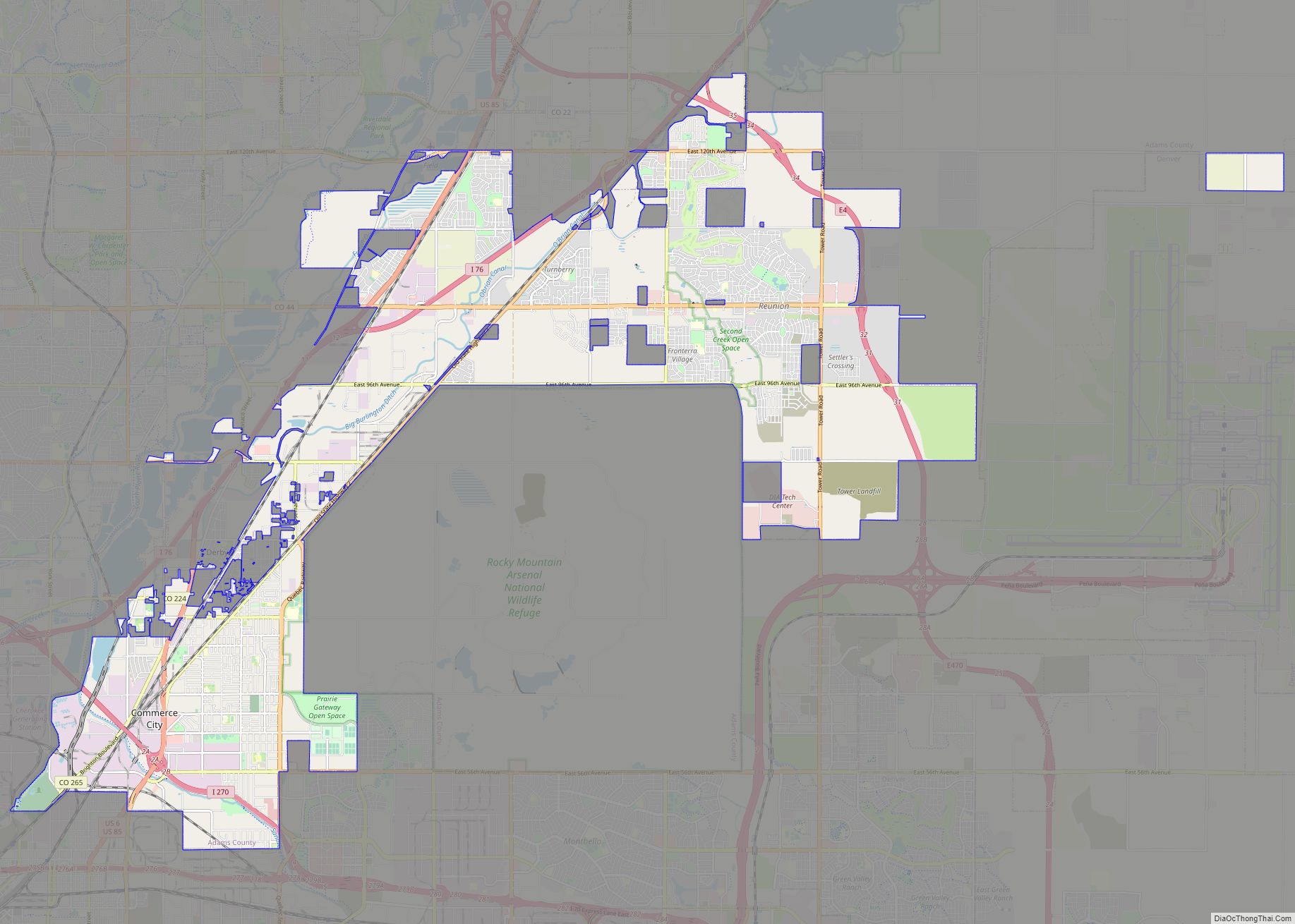
The City of Commerce City is a home rule municipality located in Adams County, Colorado, United States. The city population was 62,418 at the 2020 United States Census, a 35.95% increase since the 2010 United States Census. Commerce City is the 18th most populous municipality in Colorado. Commerce City is located north of Denver and … Read more

Map of Comanche Creek CDP

Map of Comanche Creek CDP

Comanche Creek is an unincorporated community and a census-designated place (CDP) located in and governed by Arapahoe County, Colorado, United States. The CDP is a part of the Denver–Aurora–Lakewood, CO Metropolitan Statistical Area. The population of the Comanche Creek CDP was 442 at the United States Census 2020. The Strasburg post office (Zip code 80136) … Read more

Map of Cotopaxi CDP

Map of Cotopaxi CDP

Cotopaxi is an unincorporated town, a post office, and a census-designated place (CDP) located in and governed by Fremont County, Colorado, United States. The CDP is a part of the Cañon City, CO Micropolitan Statistical Area. The Cotopaxi post office has the ZIP Code 81223. At the United States Census 2020, the population of the … Read more

Map of Cortez city

Map of Cortez city, Colorado

Cortez (/ˈkɔːrtɛz/ (listen)) is a home rule municipality that is the county seat and the most populous municipality of Montezuma County, Colorado, United States. The city population was 8,766 at the 2020 United States Census. Cortez city overview: Name: Cortez city LSAD Code: 25 LSAD Description: city (suffix) State: Colorado County: Montezuma County Elevation: 6,191 ft … Read more

Map of Copper Mountain CDP

Map of Copper Mountain CDP

Copper Mountain is an unincorporated community and a census-designated place (CDP) located in and governed by Summit County, Colorado, United States. The CDP is a part of the Breckenridge, CO Micropolitan Statistical Area. The population of the Copper Mountain CDP was 650 at the United States Census 2020. The Copper Mountain Consolidated Metropolitan District provides … Read more

Map of Crested Butte town

Map of Crested Butte town

Crested Butte is a home rule municipality located in Gunnison County, Colorado, United States. The town population was 1,639 at the 2020 United States Census. The former coal mining town is now called “the last great Colorado ski town”. Crested Butte is a destination for skiing, mountain biking, and outdoor activities. The Colorado General Assembly … Read more

Map of Crawford town

Map of Crawford town, Colorado

The Town of Crawford is a Statutory Town in Delta County, Colorado, United States. The town population was 403 at the 2020 United States Census. The surrounding mesas and valleys support a farming and ranching community. Crawford town overview: Name: Crawford town LSAD Code: 43 LSAD Description: town (suffix) State: Colorado County: Delta County Incorporated: … Read more

Map of Craig city, Colorado

Map of Craig city, Colorado

Craig is a home rule municipality that is the county seat and the most populous municipality of Moffat County, Colorado, United States. The city population was 9,060 at the 2020 United States Census. Craig is the principal city of the Craig, CO Micropolitan Statistical Area. Craig city overview: Name: Craig city LSAD Code: 25 LSAD … Read more

Map of Crisman CDP

Map of Crisman CDP

Crisman is an unincorporated community and a census-designated place (CDP) located in and governed by Boulder County, Colorado, United States. The CDP is a part of the Boulder, CO Metropolitan Statistical Area. The population of the Crisman CDP was 179 at the United States Census 2020. The Boulder post office (Zip Code 80302) serves the … Read more

Map of Cripple Creek city

Map of Cripple Creek city

Cripple Creek is a statutory city that is the county seat of Teller County, Colorado, United States. The city population was 1,155 at the 2020 United States Census. Cripple Creek is a former gold mining camp located 20 miles (32 km) southwest of Colorado Springs near the base of Pikes Peak. The Cripple Creek Historic District, … Read more

Map of Crestone town

Map of Crestone town

The Town of Crestone is a Statutory Town in Saguache County, Colorado. According to the 2020 United States Census the town population was 141. Crestone is located at the foot of the western slope of the Sangre de Cristo Range, in the northern part of the San Luis Valley. Crestone was platted in 1880 by … Read more

Map of Dacono city

Map of Dacono city

Dacono is a home rule municipality located in southwestern Weld County, Colorado, United States. The city population was 6,297 at the 2020 United States Census, an increase of +51.66% since the 2010 United States Census. Dacono is a part of the Greeley, CO Metropolitan Statistical Area and the Front Range Urban Corridor. Dacono city overview: … Read more