Map of Conning Towers Nautilus Park CDP

Map of Conning Towers Nautilus Park CDP

Conning Towers Nautilus Park is a census-designated place (CDP) in the town of Groton in New London County, Connecticut, United States. The population was 9,828 at the 2010 census. The statistical area consists of the portion of the town in the vicinity of Route 12 and includes Naval Submarine Base New London. Conning Towers Nautilus … Read more

Map of Coventry Lake CDP

Map of Coventry Lake CDP

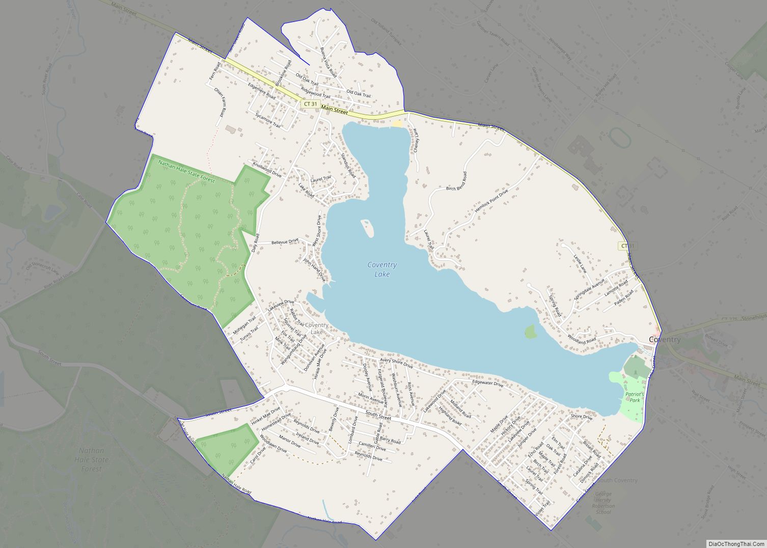
Coventry Lake is a village and census-designated place in the town of Coventry, Connecticut in Tolland County, Connecticut, United States. The population was 2,990 at the 2010 census. The CDP includes the residential areas around Wangumbaug Lake. Coventry Lake CDP overview: Name: Coventry Lake CDP LSAD Code: 57 LSAD Description: CDP (suffix) State: Connecticut County: … Read more

Map of Cos Cob CDP

Map of Cos Cob CDP

Cos Cob is a neighborhood and census-designated place in the town of Greenwich, Connecticut. It is located on the Connecticut shoreline in southern Fairfield County. It had a population of 6,770 at the 2010 census. Cos Cob is located on the western side of the mouth of the Mianus River. The American Impressionist Cos Cob … Read more

Map of Danielson borough

Map of Danielson borough

Danielson borough overview: Name: Danielson borough LSAD Code: 21 LSAD Description: borough (suffix) State: Connecticut County: Windham County FIPS code: 0918780 Online Interactive Map Danielson online map. Source: Basemap layers from Google Map, Open Street Map (OSM), Arcgisonline, Wmflabs. Boundary Data from Database of Global Administrative Areas. Danielson location map. Where is Danielson borough? Danielson … Read more

Map of Danbury city

Map of Danbury city, Connecticut

Danbury is a city in Fairfield County, Connecticut, United States, located approximately 50 miles (80 km) northeast of New York City. Danbury’s population as of 2020 was 86,518. It is the third largest city in Western Connecticut, and the seventh largest city in Connecticut. Danbury is nicknamed the “Hat City” because it was the center of … Read more

Map of Crystal Lake CDP

Map of Crystal Lake CDP, Connecticut

Crystal Lake is a village, census-designated place, and part of the town of Ellington, in Tolland County, Connecticut, United States. The population was 1,945 at the 2010 census. The CDP includes an eponymous lake. Crystal Lake CDP overview: Name: Crystal Lake CDP LSAD Code: 57 LSAD Description: CDP (suffix) State: Connecticut County: Tolland County Elevation: … Read more

Map of Derby city, Connecticut

Map of Derby city, Connecticut

Derby /ˈdɜːrbi/ is a city in New Haven County, Connecticut, United States, approximately 8 miles (13 km) west-northwest of New Haven. It is located in southwest Connecticut at the confluence of the Housatonic and Naugatuck rivers. It shares borders with the cities of Ansonia to the north and Shelton to the southwest, and the towns of … Read more

Map of Deep River Center CDP

Map of Deep River Center CDP

Deep River Center is a census-designated place (CDP) comprising the primary village in the town of Deep River, Middlesex County, Connecticut, United States. It is in the east-central part of the town, bordered to the north by the town of Chester, to the south by the town of Essex, to the east by Pratt Cove, … Read more

Map of Darien CDP

Map of Darien CDP, Connecticut

Darien Downtown is a census-designated place (CDP) in the town of Darien, Fairfield County, Connecticut, United States. It represents the built-up center of town around the intersections of U.S. Route 1 (Boston Post Road), Connecticut Route 124 (Mansfield Avenue), and Connecticut Route 136 (Tokeneke Road). Interstate 95 passes through the southern part of the CDP, … Read more

Map of East Hampton CDP

Map of East Hampton CDP, Connecticut

East Hampton is a census-designated place (CDP) comprising the primary village and adjacent residential and rural land in the town of East Hampton, Middlesex County, Connecticut, United States. It is in the central and eastern portions of the town, bordered to the north by the East Hampton community of Lake Pocotopaug and to the east … Read more

Map of East Brooklyn CDP

Map of East Brooklyn CDP, Connecticut

East Brooklyn is a census-designated place located within the town of Brooklyn in Windham County, Connecticut. It is the portion of the Danielson urban cluster within the town of Brooklyn. The population was 1,638 at the 2010 census. US 6 runs through the town and severs the town. The portion of the CDP near the … Read more

Map of Durham CDP, Connecticut

Map of Durham CDP, Connecticut

Durham is a census-designated place (CDP) comprising the primary village and surrounding development in the town of Durham, Middlesex County, Connecticut, United States. It is in the central and northeastern portions of the town, bordered to the north by the town of Middlefield and the city of Middletown. As of the 2020 census, the CDP … Read more