Map of Essex Village CDP

Map of Essex Village CDP

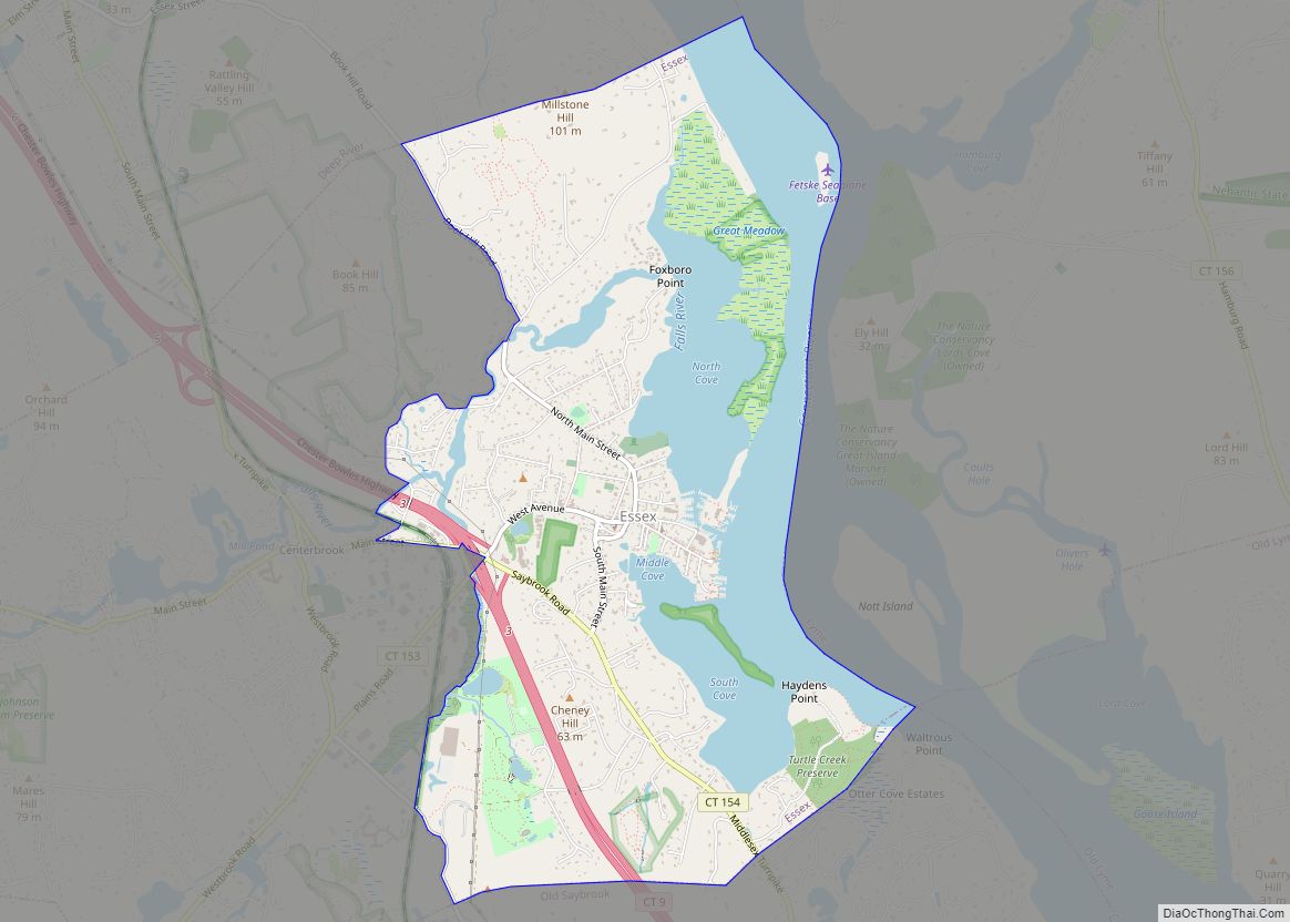
Essex Village is a village and census-designated place (CDP) in the town of Essex, Connecticut, in the United States. The population was 2,583 at the 2020 census, out of 6,733 in the entire town of Essex. The government offices of the town are located within the village. Essex Village CDP overview: Name: Essex Village CDP … Read more

Map of East Haven CDP

Map of East Haven CDP

East Haven is a town in New Haven County, Connecticut, in the United States. As of the 2020 census, the town population was 27,923. The town is located 3 miles (5 km) east of New Haven, and is part of the South Central Connecticut Planning Region. East Haven is 35 miles (56 km) from Hartford, 82 miles … Read more

Map of East Hartford CDP

Map of East Hartford CDP

East Hartford is a town in the Capitol Planning Region, Connecticut, United States. The population was 51,045 at the 2020 census. The town is located on the east bank of the Connecticut River, directly across from Hartford, Connecticut. It is home to aerospace manufacturer Pratt & Whitney. It is also home to Pratt & Whitney … Read more

Map of Gales Ferry CDP

Map of Gales Ferry CDP

Gales Ferry is a village in the town of Ledyard, Connecticut, United States. It is located along the eastern bank of the Thames River. The village developed as a result of having a ferry to Uncasville located at this site, and from which the village was named. Gales Ferry was listed as a census-designated place … Read more

Map of Fenwick borough

Map of Fenwick borough, Connecticut

Fenwick borough overview: Name: Fenwick borough LSAD Code: 21 LSAD Description: borough (suffix) State: Connecticut County: Middlesex County FIPS code: 0927810 Online Interactive Map Fenwick online map. Source: Basemap layers from Google Map, Open Street Map (OSM), Arcgisonline, Wmflabs. Boundary Data from Database of Global Administrative Areas. Fenwick location map. Where is Fenwick borough? Fenwick … Read more

Map of Falls Village CDP

Map of Falls Village CDP

Falls Village is a village and census-designated place in the town of Canaan in Litchfield County, Connecticut, United States. As of the 2010 census it had a population of 538, out of 1,234 in the entire town of Canaan. Because Falls Village is the town center and principal constituent village in Canaan, the entire town … Read more

Map of Glenville CDP

Map of Glenville CDP, Connecticut

Glenville is a neighborhood and census-designated place in the town of Greenwich in Fairfield County, Connecticut, United States. As of the 2010 census, it had a population of 2,327. It is located in the western part of Greenwich at the falls of the Byram River, which provided waterpower when this was a mill village. The … Read more

Map of Glastonbury Center CDP

Map of Glastonbury Center CDP

Glastonbury Center is a census-designated place (CDP) that constitutes the densely populated center of the town of Glastonbury in Hartford County, Connecticut, United States. The population was 7,387 at the 2010 census, out of a total town population of 34,427. Glastonbury Center CDP overview: Name: Glastonbury Center CDP LSAD Code: 57 LSAD Description: CDP (suffix) … Read more

Map of Georgetown CDP, Connecticut

Map of Georgetown CDP, Connecticut

Georgetown is a census-designated place in Fairfield County, Connecticut, United States. It is located in the area where the towns of Wilton, Redding, Weston, and Ridgefield meet. Georgetown and its surrounding area are also defined as the Georgetown census-designated place (CDP). As of the 2010 census, the population of the CDP was 1,805. Georgetown is … Read more

Map of Greenwich CDP

Map of Greenwich CDP, Connecticut

Greenwich is a census-designated place (CDP) in Fairfield County, Connecticut, United States. It is one of several CDPs within the town of Greenwich and corresponds to the historic municipal center of the town and surrounding residential and commercial areas. As of the 2010 census, the population of the Greenwich CDP was 12,942, out of 61,171 … Read more

Map of Groton city

Map of Groton city, Connecticut

Groton /ˈɡrɒtən/ is a town in New London County, Connecticut located on the Thames River. It is the home of General Dynamics Electric Boat, which is the major contractor for submarine work for the United States Navy. The Naval Submarine Base New London is located in Groton, and the pharmaceutical company Pfizer is also a … Read more

Map of Groton Long Point borough

Map of Groton Long Point borough

Groton Long Point borough overview: Name: Groton Long Point borough LSAD Code: 21 LSAD Description: borough (suffix) State: Connecticut County: New London County FIPS code: 0934460 Online Interactive Map Groton Long Point online map. Source: Basemap layers from Google Map, Open Street Map (OSM), Arcgisonline, Wmflabs. Boundary Data from Database of Global Administrative Areas. Groton … Read more