Map of Bronson town

Map of Bronson town, Florida

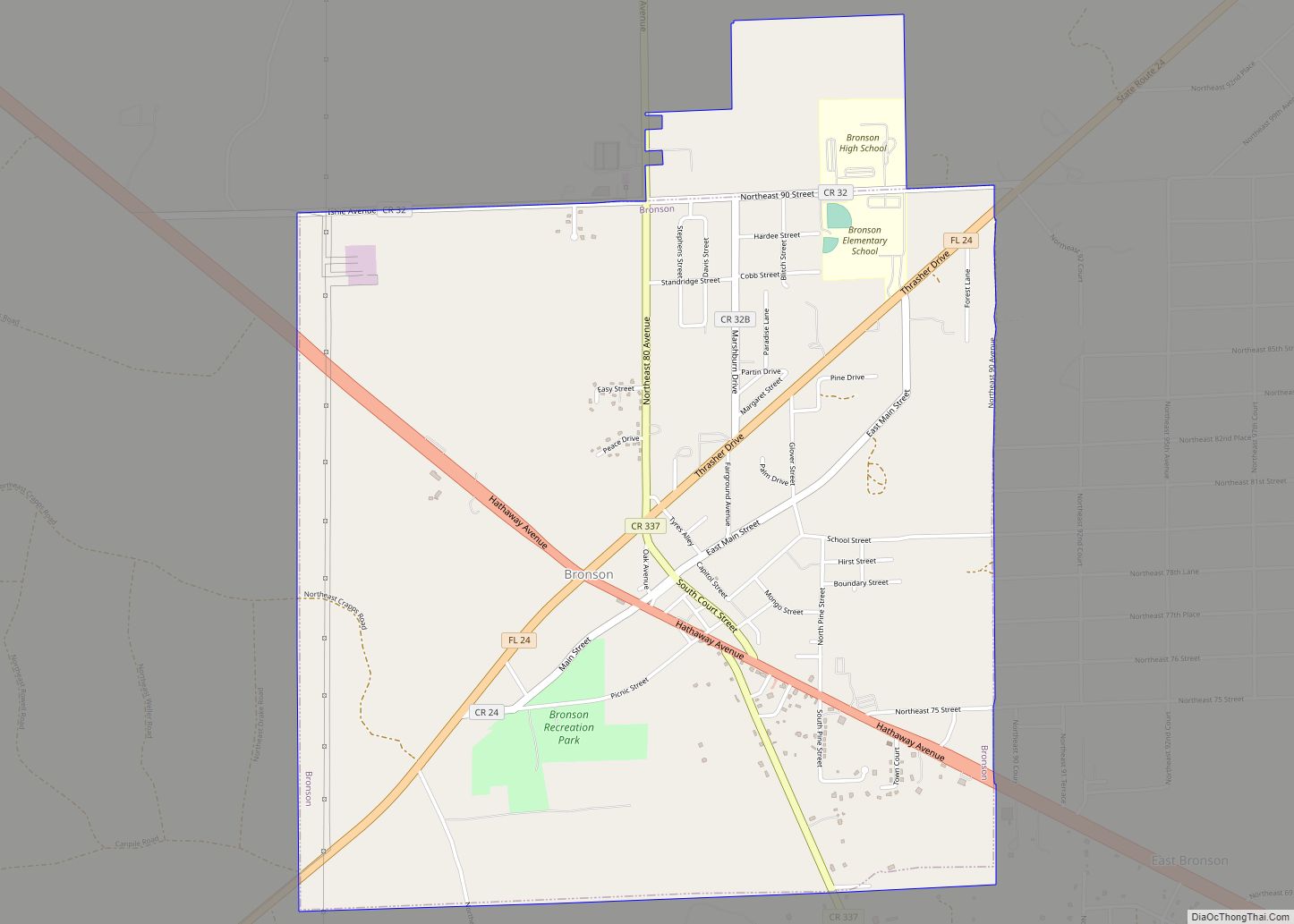
Bronson is a town and the county seat of Levy County, Florida, United States. The population was 1,113 at the 2010 census. Bronson town overview: Name: Bronson town LSAD Code: 43 LSAD Description: town (suffix) State: Florida County: Levy County Elevation: 59 ft (18 m) Total Area: 4.37 sq mi (11.32 km²) Land Area: 4.28 sq mi (11.09 km²) Water Area: 0.09 sq mi (0.23 km²) … Read more

Map of Broadview Park CDP

Map of Broadview Park CDP

Broadview Park is a census-designated place (CDP) in Broward County, Florida, United States. The population was 7,125 at the 2010 census. Broadview Park CDP overview: Name: Broadview Park CDP LSAD Code: 57 LSAD Description: CDP (suffix) State: Florida County: Broward County Elevation: 16 ft (5 m) Total Area: 1.05 sq mi (2.72 km²) Land Area: 1.00 sq mi (2.59 km²) Water Area: 0.05 sq mi … Read more

Map of Bristol city, Florida

Map of Bristol city, Florida

Bristol is a city in and the county seat of Liberty County, Florida, United States. It is the only incorporated city in Liberty County. The population was 996 at the 2010 census, up from 845 at the 2000 census. Two schools are based in Bristol: Liberty County High School and W. R. Tolar Elementary and … Read more

Map of Brooksville city

Map of Brooksville city, Florida

Brooksville is a city in and the county seat of Hernando County, Florida, United States. As of the 2010 census it had a population of 7,719, up from 7,264 at the 2000 census. Brooksville is home to historic buildings and residences, including the homes of former Florida Governor William Sherman Jennings and football player Jerome … Read more

Map of Brookridge CDP

Map of Brookridge CDP

Brookridge is a census-designated place (CDP) in Hernando County, Florida, United States. The population was 4,420 at the 2010 census, up from 3,279 at the 2000 census. Brookridge CDP overview: Name: Brookridge CDP LSAD Code: 57 LSAD Description: CDP (suffix) State: Florida County: Hernando County Elevation: 62 ft (19 m) Total Area: 2.53 sq mi (6.56 km²) Land Area: 2.53 sq mi … Read more

Map of Brooker town

Map of Brooker town

Brooker is a town in Bradford County, Florida, United States. The population was 338 at the 2010 census. Brooker town overview: Name: Brooker town LSAD Code: 43 LSAD Description: town (suffix) State: Florida County: Bradford County Elevation: 128 ft (39 m) Total Area: 0.53 sq mi (1.37 km²) Land Area: 0.53 sq mi (1.37 km²) Water Area: 0.00 sq mi (0.00 km²) Total Population: 322 Population … Read more

Map of Buckhead Ridge CDP

Map of Buckhead Ridge CDP

Buckhead Ridge is a census-designated place (CDP) in Glades County, Florida, United States. The population was 1,450 at the 2010 census. The community consists of a few small commercial developments and a large mobile home park. Most residential lots in the community abut canals that feed into Lake Okeechobee. Buckhead Ridge CDP overview: Name: Buckhead … Read more

Map of Brownsville city

Map of Brownsville CDP, Florida

Brownsville (also known as Brown Sub) is an unincorporated community and census-designated place (CDP) in metropolitan Miami, Florida, United States. As of the 2010 census, the population was 16,583, up from 15,313 in 2010. After three decades of population loss, Brownsville gained population for the first time in over 40 years in the 2010 US … Read more

Map of Brownsdale CDP

Map of Brownsdale CDP, Florida

Brownsdale is an unincorporated community and census-designated place in Santa Rosa County, Florida, United States. Its population was 471 as of the 2010 census. Brownsdale CDP overview: Name: Brownsdale CDP LSAD Code: 57 LSAD Description: CDP (suffix) State: Florida County: Santa Rosa County Elevation: 243 ft (74 m) Total Area: 8.892 sq mi (23.03 km²) Land Area: 8.700 sq mi (22.53 km²) Water … Read more

Map of Buckingham CDP

Map of Buckingham CDP, Florida

Buckingham is an unincorporated community and census-designated place (CDP) in Lee County, Florida, United States. The population was 4,443 at the 2020 census, up from 4,036 at the 2010 census. It is part of the Cape Coral-Fort Myers, Florida Metropolitan Statistical Area. Historic Buckingham School is located there. Buckingham CDP overview: Name: Buckingham CDP LSAD … Read more

Map of Bunnell city

Map of Bunnell city

Bunnell is the county seat of Flagler County Florida, United States, with a population of 2,676 at the 2010 census. The city is part of the Deltona–Daytona Beach–Ormond Beach, FL metropolitan statistical area and is named after an early resident, Alvah A. Bunnell, a shingle maker and supplier of wood to the area’s fledgling rail … Read more

Map of Buenaventura Lakes CDP

Map of Buenaventura Lakes CDP

Buena Ventura Lakes, more commonly known as BVL, is a census-designated place (CDP) in northern Osceola County, Florida, United States, near Kissimmee. Its population was 26,079 at the 2010 census. It is part of the Orlando–Kissimmee–Sanford, Florida Metropolitan Statistical Area. The community is served by the Osceola Library System. Buena Ventura Lakes is very well … Read more