Map of Butler Beach CDP

Map of Butler Beach CDP

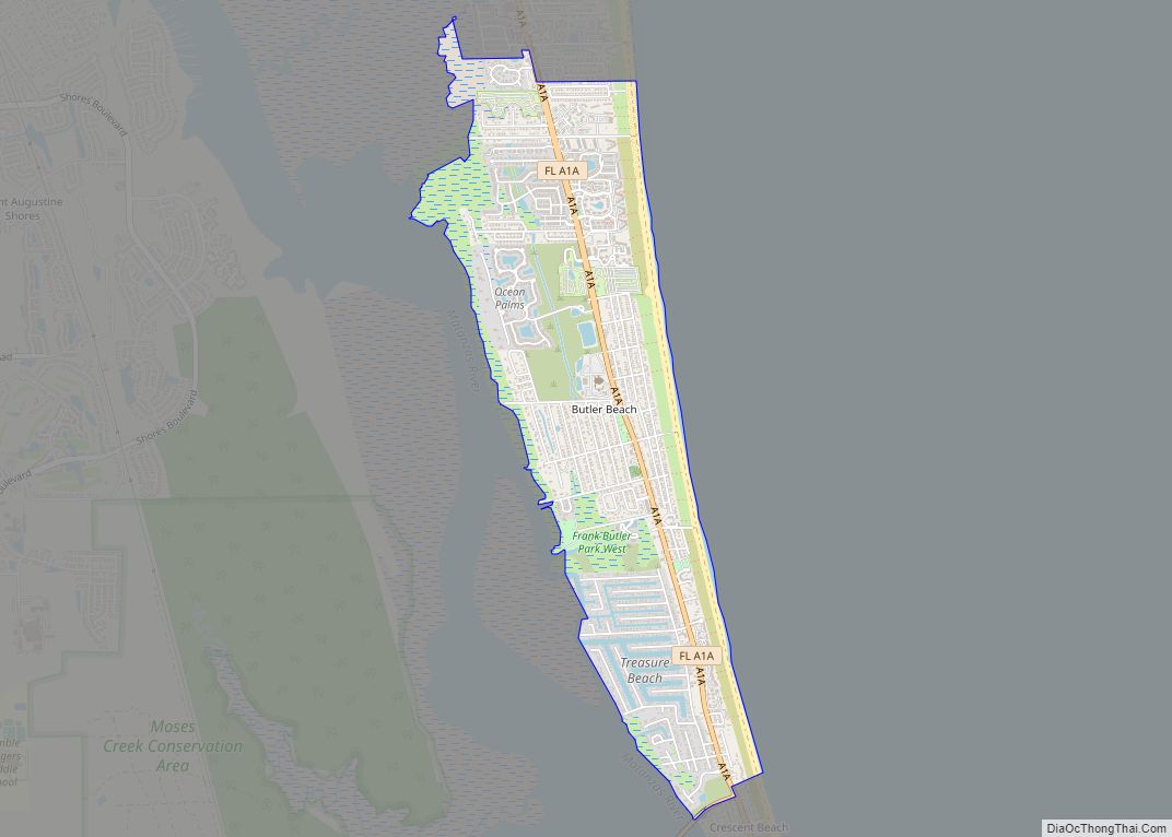
Butler Beach is a census-designated place (CDP) in St. Johns County, Florida, United States. The population was 4,978 at the time of the 2020 United States Census. Butler Beach CDP overview: Name: Butler Beach CDP LSAD Code: 57 LSAD Description: CDP (suffix) State: Florida County: St. Johns County Elevation: 3 ft (1 m) Total Area: 2.66 sq mi (6.88 km²) … Read more

Map of Bushnell city

Map of Bushnell city, Florida

Bushnell is a city in western Florida and is the county seat of Sumter County, Florida, United States. The population was 2,418 at the 2010 census. According to the U.S. Census estimates of 2018, the city had a population of 3,119. Bushnell city overview: Name: Bushnell city LSAD Code: 25 LSAD Description: city (suffix) State: … Read more

Map of Burnt Store Marina CDP

Map of Burnt Store Marina CDP

Burnt Store Marina is an unincorporated community and census-designated place (CDP) in Lee County, Florida, United States. The population was 1,890 at the 2020 census, up from 1,793 at the 2010 census. It is part of the Cape Coral-Fort Myers, Florida Metropolitan Statistical Area. Burnt Store Marina CDP overview: Name: Burnt Store Marina CDP LSAD … Read more

Map of Cabana Colony CDP

Map of Cabana Colony CDP

Cabana Colony is a census-designated place in Palm Beach County, Florida, United States. Its population was 2,460 as of the 2020 census. Cabana Colony is located on the east side of State Road 811 and borders Palm Beach Gardens on three sides. The 2010 U.S. Census depicts 42.2% of the population in Cabana Colony is … Read more

Map of Callaway city

Map of Callaway city, Florida

Callaway is a city in Bay County, Florida, United States, and is a suburb of Panama City. The population was 14,405 at the 2010 census. It is part of the Panama City–Lynn Haven–Panama City Beach Metropolitan Statistical Area. The first arrest for the sale to a minor of an explicit album (The 2 Live Crew … Read more

Map of Callahan town

Map of Callahan town

Callahan is a town in Nassau County, Florida, United States, adjacent to Duval County. The population was 1,123 at the 2010 census. It is one location of the Northeast Florida Fair. Callahan town overview: Name: Callahan town LSAD Code: 43 LSAD Description: town (suffix) State: Florida County: Nassau County Elevation: 20 ft (6 m) Total Area: 1.81 sq mi … Read more

Map of Canal Point CDP

Map of Canal Point CDP

Canal Point is a census-designated place (CDP) and unincorporated community in Palm Beach County, Florida, United States. Canal Point is located along the eastern shore of Lake Okeechobee, to the northeast of Pahokee and to the northwest of Bryant. The unincorporated community was originally inhabited by the Calusa tribe until almost 400 years ago. Whites began … Read more

Map of Campbellton town

Map of Campbellton town

Campbellton is a town in Jackson County, Florida, United States. The population was 230 at the 2010 census. Campbellton town overview: Name: Campbellton town LSAD Code: 43 LSAD Description: town (suffix) State: Florida County: Jackson County Elevation: 184 ft (56 m) Total Area: 2.68 sq mi (6.93 km²) Land Area: 2.60 sq mi (6.72 km²) Water Area: 0.08 sq mi (0.21 km²) Total Population: 191 Population … Read more

Map of Campbell CDP, Florida

Map of Campbell CDP, Florida

Campbell (often referred to locally as Campbell City) is a census-designated place and an unincorporated community in Osceola County, Florida, United States. Campbell City was named after Alfred Sidney Campbell who opened and operated the general store in the settlement. The population was 2,479 at the 2010 census. It is part of the Orlando–Kissimmee Metropolitan … Read more

Map of Carrabelle city

Map of Carrabelle city

Carrabelle is a city in Franklin County along Florida‘s Panhandle, United States. The population was 2,778 as of the 2010 census. Carrabelle is located east of Apalachicola at the mouth of the Carrabelle River on the Gulf of Mexico. Carrabelle city overview: Name: Carrabelle city LSAD Code: 25 LSAD Description: city (suffix) State: Florida County: … Read more

Map of Captiva CDP

Map of Captiva CDP

Captiva is an unincorporated community and census-designated place (CDP) in Lee County, Florida, United States. It is located on Captiva Island. As of the 2020 census the population was 318, down from 583 at the 2010 census. It is part of the Cape Coral-Fort Myers, Florida Metropolitan Statistical Area. Located just offshore in the Gulf … Read more

Map of Cape Canaveral city

Map of Cape Canaveral city

Cape Canaveral (Spanish: Cabo Cañaveral) is a city in Brevard County, Florida. The population was 9,912 at the 2010 United States Census. It is part of the Palm Bay–Melbourne–Titusville Metropolitan Statistical Area. Cape Canaveral city overview: Name: Cape Canaveral city LSAD Code: 25 LSAD Description: city (suffix) State: Florida County: Brevard County Incorporated: 1963 Elevation: … Read more