Map of Clewiston city

Map of Clewiston city

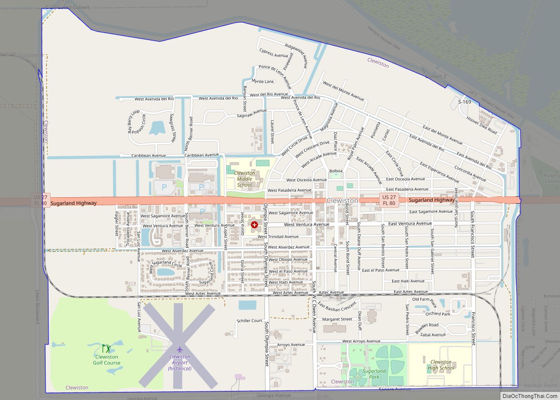
Clewiston is a city in Hendry County, Florida, United States. Its location is 80 miles (130 km) northwest of Fort Lauderdale on the Atlantic coastal plain. The population was 7,327 at the 2020 census, up from 7,155 at the 2010 census. The estimated population in 2018 was 7,985. The city is located on the south bank … Read more

Map of Cleveland CDP, Florida

Map of Cleveland CDP, Florida

Cleveland is a census-designated place (CDP) in Charlotte County, Florida, United States. The population was 3,435 at the 2020 census. It is part of the Sarasota-Bradenton-Punta Gorda Combined Statistical Area. Cleveland CDP overview: Name: Cleveland CDP LSAD Code: 57 LSAD Description: CDP (suffix) State: Florida County: Charlotte County Elevation: 7 ft (2 m) Total Area: 5.72 sq mi (14.81 km²) … Read more

Map of Clermont city

Map of Clermont city, Florida

Clermont is a city in Lake County in central Florida, United States, about 22 miles (35 km) west of Orlando and 22 miles (35 km) southeast of Leesburg. The population was 43,021 in 2020. The city is residential in character and its economy is centered in retail trade, lodging, and tourism-oriented restaurants and bars. It is part … Read more

Map of Cocoa Beach city

Map of Cocoa Beach city

Cocoa Beach is a city in Brevard County, Florida, United States. The population was 11,539 at the 2018 United States Census. It is part of the Palm Bay–Melbourne–Titusville, Florida Metropolitan Statistical Area. Cocoa Beach city overview: Name: Cocoa Beach city LSAD Code: 25 LSAD Description: city (suffix) State: Florida County: Brevard County Elevation: 10 ft (3 m) … Read more

Map of Cobbtown CDP

Map of Cobbtown CDP, Florida

Cobbtown is an unincorporated community and census-designated place in Santa Rosa County, Florida, United States. Its population was 67 as of the 2010 census. Cobbtown CDP overview: Name: Cobbtown CDP LSAD Code: 57 LSAD Description: CDP (suffix) State: Florida County: Santa Rosa County Elevation: 180 ft (50 m) Total Area: 2.651 sq mi (6.87 km²) Land Area: 2.635 sq mi (6.82 km²) Water … Read more

Map of Cloud Lake town

Map of Cloud Lake town

Cloud Lake is a town in Palm Beach County, Florida, United States. Cloud Lake has a population of 135 during the 2010 census. The town is situated adjacent to Glen Ridge and West Palm Beach and is located near the Palm Beach International Airport. Established in 1951, Cloud Lake was built largely by the efforts … Read more

Map of Coconut Creek city

Map of Coconut Creek city

Coconut Creek is a city in Broward County, Florida, United States. Situated 37 miles (60 km) north of Miami, it had a population of 57,833 in 2020. It is part of the Miami-Fort Lauderdale-West Palm Beach, FL Metropolitan Statistical Area. The city seceded from Pompano Beach in the 1960s. It is nicknamed “Butterfly Capital of the … Read more

Map of Cocoa city

Map of Cocoa city

Cocoa is a city in Brevard County, Florida. The population was 19,041 at the 2020 United States Census. It is part of the Palm Bay–Melbourne–Titusville Metropolitan Statistical Area. Cocoa city overview: Name: Cocoa city LSAD Code: 25 LSAD Description: city (suffix) State: Florida County: Brevard County Elevation: 36 ft (11 m) Total Area: 14.75 sq mi (38.21 km²) Land Area: … Read more

Map of Cocoa West CDP

Map of Cocoa West CDP

Cocoa West is a census-designated place (CDP) in Brevard County, Florida, United States. The population was 5,925 at the 2010 census. It is the closest place to Lake Poinsett and Canaveral Groves. Cocoa West is part of the Palm Bay–Melbourne–Titusville Metropolitan Statistical Area. Cocoa West CDP overview: Name: Cocoa West CDP LSAD Code: 57 LSAD … Read more

Map of Coleman city

Map of Coleman city, Florida

Coleman is a city in Sumter County, Florida, United States. The population was 703 at the 2010 census. According to the U.S. Census estimates of 2018, the city had a population of 877. Coleman city overview: Name: Coleman city LSAD Code: 25 LSAD Description: city (suffix) State: Florida County: Sumter County Elevation: 66 ft (20 m) Total … Read more

Map of Connerton CDP

Map of Connerton CDP

Connerton is a census-designated place in Pasco County, Florida, United States, off U.S. 41. Its population was 5,282 as of the 2020 census. Connerton Elementary was constructed in the area. The Conner family owned and operated Conner Ranch, a working cattle ranch set on the 8,000 acres that now makes up Connerton. The family sold … Read more

Map of Combee Settlement CDP

Map of Combee Settlement CDP

Combee Settlement is a census-designated place and unincorporated area in Polk County, Florida, United States. The population was 5,436 at the 2000 census. It is part of the Lakeland–Winter Haven Metropolitan Statistical Area. The area includes the separate unincorporated community of Country Club Estates. Combee Settlement CDP overview: Name: Combee Settlement CDP LSAD Code: 57 … Read more