Map of Destin city

Map of Destin city

Destin is a city located in Okaloosa County, Florida, United States. It is a principal city of the Crestview–Fort Walton Beach–Destin metropolitan area. Located on Florida’s Emerald Coast, Destin is known for its white beaches and emerald green waters. Originating as a small fishing village, it is now a popular tourist destination. According to the … Read more

Map of Desoto Lakes CDP

Map of Desoto Lakes CDP

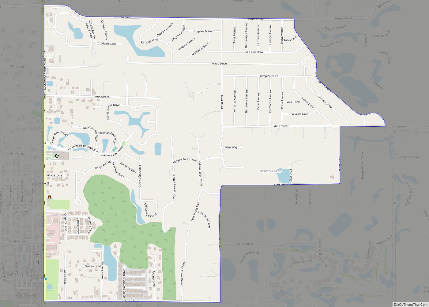
Desoto Lakes is a census-designated place (CDP) in Sarasota County, Florida, United States. The population was 3,646 at the 2010 US Census. It is part of the Bradenton–Sarasota–Venice Metropolitan Statistical Area. Desoto Lakes CDP overview: Name: Desoto Lakes CDP LSAD Code: 57 LSAD Description: CDP (suffix) State: Florida County: Sarasota County Elevation: 30 ft (9 m) Total … Read more

Map of Deltona city

Map of Deltona city

Deltona is a city in Volusia County, Florida, United States. It is located on the northern shore of Lake Monroe along the St. Johns River. As of the 2020 census, the city population was 93,692. It is a principal city of the Deltona–Daytona Beach–Ormond Beach metropolitan area, which was home to an estimated 685,344 people … Read more

Map of Doctor Phillips CDP

Map of Doctor Phillips CDP

Dr. Phillips is a census-designated place and an unincorporated area in Orange County, Florida, United States. It is a suburb of Orlando and is part of the Orlando–Kissimmee–Sanford, Florida Metropolitan Statistical Area. The population was 12,328 at the 2020 census. The area of Dr. Phillips is named after Philip Phillips, a Central Florida citrus magnate. … Read more

Map of Dixonville CDP

Map of Dixonville CDP

Dixonville is an unincorporated community and census-designated place in Santa Rosa County, Florida, United States. Its population was 181 as of the 2010 census. Florida State Road 87 passes through the community. The community name continues north of the state line in Alabama along Alabama State Route 41. Dixonville CDP overview: Name: Dixonville CDP LSAD … Read more

Map of Dickerson City CDP

Map of Dickerson City CDP

Dickerson City is an unincorporated community and census-designated place in Santa Rosa County, Florida, United States. Its population was 146 as of the 2010 census. The community is located on the eastern side of Garcon Point. Dickerson City CDP overview: Name: Dickerson City CDP LSAD Code: 57 LSAD Description: CDP (suffix) State: Florida County: Santa … Read more

Map of Duck Key CDP

Map of Duck Key CDP

Duck Key is a census-designated place and unincorporated community in Monroe County, Florida, United States, on an island of the same name in the middle Florida Keys. The CDP also includes the neighboring island of Conch Key. As of the 2020 census, the CDP had a population of 727, up from 621 in 2010. Duck … Read more

Map of Dover CDP, Florida

Map of Dover CDP, Florida

Dover is an unincorporated census-designated place in Hillsborough County, Florida, United States. The population was 3,266 at the 2020 census, down from 3,702 at the 2010 census. Dover CDP overview: Name: Dover CDP LSAD Code: 57 LSAD Description: CDP (suffix) State: Florida County: Hillsborough County Elevation: 102 ft (31 m) Total Area: 2.64 sq mi (6.84 km²) Land Area: 2.60 sq mi … Read more

Map of Doral city

Map of Doral city

Doral is a city in Miami-Dade County, Florida, United States. One of 34 municipalities in the county, it is located 5 miles (8 km) west of Miami International Airport and 13 miles (21 km) west of Downtown Miami. Doral occupies 15 square miles (39 km) bordered on the west by the Ronald Reagan Turnpike and the Florida Everglades, … Read more

Map of Dunnellon city

Map of Dunnellon city

Dunnellon is a city with the unique feature of sitting in 3 counties in Marion, Levy & Citrus counties in Florida, United States. The predominant part falls in the Marion county. The population was 1,928 at the 2020 census, up from 1,733 in 2010. It is part of the Ocala Metropolitan Statistical Area. Dunnellon city … Read more

Map of Dunedin city

Map of Dunedin city

Dunedin /dəˈniːdɪn/ is a city in Pinellas County, Florida, United States. The name comes from Dùn Èideann, the Scottish Gaelic name for Edinburgh, the capital of Scotland. Dunedin is part of the Tampa-St. Petersburg-Clearwater metropolitan area and is the fifth largest city in Pinellas County. The population was 36,068 as of the 2020 census. Dunedin … Read more

Map of Dundee town

Map of Dundee town, Florida

Dundee is a town in Polk County, Florida, United States. The population was 3,717 at the 2010 census. It is part of the Lakeland–Winter Haven Metropolitan Statistical Area. Dundee town overview: Name: Dundee town LSAD Code: 43 LSAD Description: town (suffix) State: Florida County: Polk County Incorporated: 1924 Elevation: 213 ft (65 m) Total Area: 12.13 sq mi (31.41 km²) … Read more