Map of Mangonia Park town

Map of Mangonia Park town

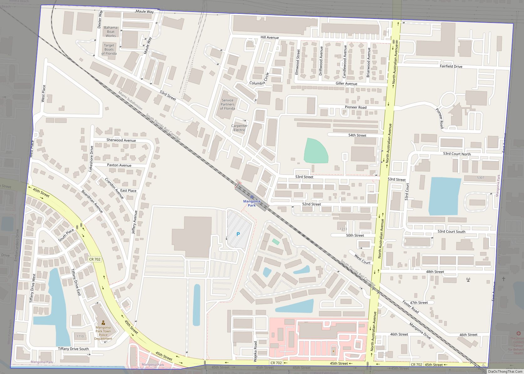
Mangonia Park is a town in Palm Beach County, Florida, United States. It is a part of Uptown West Palm, which also includes Riviera Beach and West Palm Beach. The population was 1,888 at the 2010 census. As of 2018, the population recorded by the U.S. Census Bureau was 2,017. Mangonia Park town overview: Name: … Read more

Map of Mango CDP

Map of Mango CDP

Mango is a census-designated place (CDP) in Hillsborough County, Florida, United States. The population was 11,313 at the 2010 census, up from 8,842 at the 2000 census. Mango CDP overview: Name: Mango CDP LSAD Code: 57 LSAD Description: CDP (suffix) State: Florida County: Hillsborough County Elevation: 52 ft (16 m) Total Area: 4.81 sq mi (12.46 km²) Land Area: 4.67 sq mi … Read more

Map of Manatee Road CDP

Map of Manatee Road CDP

Manatee Road is a census-designated place (CDP) in Levy County, Florida, United States. The population was 2,244 at the 2010 census. At the 2000 census, the CDP was misspelled as “Manattee Road”. Manatee Road CDP overview: Name: Manatee Road CDP LSAD Code: 57 LSAD Description: CDP (suffix) State: Florida County: Levy County Elevation: 30 ft (9 m) … Read more

Map of Margate city

Map of Margate city

Margate is a city in Broward County, Florida, United States. As of the 2020 census, the city had a population of 58,712. Margate is part of the Miami metropolitan area, which was home to 6,166,488 people in 2020. Margate was founded in the 1950s, when much of it was still either part of the Everglades … Read more

Map of Marco Island city

Map of Marco Island city

Marco Island is a city and barrier island in Collier County, Florida, located 20 miles (32 km) south of Naples on the Gulf Coast of the United States. It is the largest barrier island within Southwest Florida’s Ten Thousand Islands area, which extends southerly to Cape Sable. Marco Island is home to an affluent beach community … Read more

Map of Marathon city

Map of Marathon city, Florida

Marathon is a city in the middle of the Florida Keys, in Monroe County, Florida, United States. As of the 2020 census, the city had a population of 9,689, up from 8,297 in 2010. Marathon city overview: Name: Marathon city LSAD Code: 25 LSAD Description: city (suffix) State: Florida County: Monroe County Elevation: 3 ft (1 m) … Read more

Map of Mary Esther city

Map of Mary Esther city

Mary Esther is a city in Okaloosa County, Florida, United States. The population was 3,851 at the 2010 census. It is part of the Fort Walton Beach–Crestview–Destin Metropolitan Statistical Area. Mary Esther city overview: Name: Mary Esther city LSAD Code: 25 LSAD Description: city (suffix) State: Florida County: Okaloosa County Elevation: 23 ft (7 m) Total Area: … Read more

Map of Marineland town

Map of Marineland town

The town of Marineland was established in 1940 and is in Flagler and St. Johns counties, Florida, United States. The population was 16 in the 2010 census. Marineland is located 18 miles (29 km) south of St. Augustine along Route A1A. The Marineland marine park and the town of Marineland have become synonymous, however many do … Read more

Map of Marianna city, Florida

Map of Marianna city, Florida

Marianna is a city in and the county seat of Jackson County, Florida, United States, and it is home to Chipola College. The population was 6,102 at the 2010 census. In 2018 the estimated population was 7,091. The official nickname of Marianna is “The City of Southern Charm”. Marianna city overview: Name: Marianna city LSAD … Read more

Map of Masaryktown CDP

Map of Masaryktown CDP

Masaryktown is an unincorporated community and census-designated place (CDP) in Hernando County, Florida, United States. The population was 1,077 at the 2020 census. It is named after the first president of Czechoslovakia, Tomáš Garrigue Masaryk. Masaryktown CDP overview: Name: Masaryktown CDP LSAD Code: 57 LSAD Description: CDP (suffix) State: Florida County: Hernando County Elevation: 62 ft … Read more

Map of Matlacha Isles-Matlacha Shores CDP

Map of Matlacha Isles-Matlacha Shores CDP

Matlacha Isles-Matlacha Shores is an unincorporated community and census-designated place (CDP) in Lee County, Florida, United States. The population was 227 at the 2020 census, down from 229 at the 2010 census. It is part of the Cape Coral-Fort Myers, Florida Metropolitan Statistical Area. Matlacha Isles-Matlacha Shores CDP overview: Name: Matlacha Isles-Matlacha Shores CDP LSAD … Read more

Map of Mascotte city

Map of Mascotte city

Mascotte is a city in Lake County, Florida, United States. As of the 2020 census, the population was 6,609, up from 5,101 in 2010. It is part of the Orlando–Kissimmee–Sanford Metropolitan Statistical Area. Mascotte city overview: Name: Mascotte city LSAD Code: 25 LSAD Description: city (suffix) State: Florida County: Lake County Elevation: 92 ft (28 m) Total … Read more