Map of Munson CDP

Map of Munson CDP

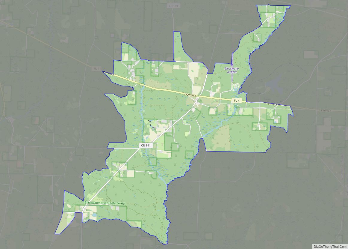
Munson is an unincorporated community and census-designated place in Santa Rosa County, Florida, United States. Its population was 372 as of the 2010 census. Florida State Road 4 passes through the community. Munson CDP overview: Name: Munson CDP LSAD Code: 57 LSAD Description: CDP (suffix) State: Florida County: Santa Rosa County Elevation: 210 ft (60 m) Total … Read more

Map of Mulberry city, Florida

Map of Mulberry city, Florida

Mulberry is a city in Polk County, Florida, United States. The population was 3,817 at the 2010 census. Mulberry is home to Badcock Home Furniture. It is part of the Lakeland–Winter Haven Metropolitan Statistical Area, with parts of unincorporated Lakeland on its northern boundary. Mulberry is home to the 334-acre Alafia River Reserve. Mulberry city … Read more

Map of Mulat CDP

Map of Mulat CDP

Mulat is an unincorporated community and census-designated place in Santa Rosa County, Florida, United States. Its population was 259 as of the 2010 census. Mulat CDP overview: Name: Mulat CDP LSAD Code: 57 LSAD Description: CDP (suffix) State: Florida County: Santa Rosa County Elevation: 10 ft (3 m) Total Area: 1.675 sq mi (4.34 km²) Land Area: 1.574 sq mi (4.08 km²) Water … Read more

Map of Naples Park CDP

Map of Naples Park CDP

Naples Park is an unincorporated community and census-designated place (CDP) in Collier County, Florida, United States. The population was 5,967 at the 2010 census. It is part of the Naples-Marco Island, Florida Metropolitan Statistical Area. Naples Park CDP overview: Name: Naples Park CDP LSAD Code: 57 LSAD Description: CDP (suffix) State: Florida County: Collier County … Read more

Map of Naples Manor CDP

Map of Naples Manor CDP

Naples Manor is a census-designated place (CDP) in Collier County, Florida, United States. The population was 5,562 at the 2010 census. It is part of the Naples–Marco Island Metropolitan Statistical Area. Naples Manor CDP overview: Name: Naples Manor CDP LSAD Code: 57 LSAD Description: CDP (suffix) State: Florida County: Collier County Elevation: 3 ft (1 m) Total … Read more

Map of Myrtle Grove CDP

Map of Myrtle Grove CDP, Florida

Myrtle Grove is a census-designated place (CDP) in Escambia County, Florida, United States. It is considered to be a community within Pensacola. The population was 15,870 at the 2010 census. It is part of the Pensacola–Ferry Pass–Brent Metropolitan Statistical Area. Myrtle Grove CDP overview: Name: Myrtle Grove CDP LSAD Code: 57 LSAD Description: CDP (suffix) … Read more

Map of Nassau Village-Ratliff CDP

Map of Nassau Village-Ratliff CDP

Nassau Village-Ratliff is a census-designated place (CDP) in Nassau County, Florida, United States. The population was 5,337 at the 2010 census. Nassau Village-Ratliff CDP overview: Name: Nassau Village-Ratliff CDP LSAD Code: 57 LSAD Description: CDP (suffix) State: Florida County: Nassau County Total Area: 14.67 sq mi (37.98 km²) Land Area: 14.67 sq mi (37.98 km²) Water Area: 0.00 sq mi (0.00 km²) Total Population: … Read more

Map of Naranja CDP

Map of Naranja CDP

Naranja is an unincorporated community and census-designated place (CDP) in Miami-Dade County, Florida, United States. Many orange groves were once located in this area, so the community name came from the Spanish word for orange, naranja, though the pronunciation among the local residents is “Na-Ran-Jah”. Naranja was also a stop for the Florida East Coast … Read more

Map of Naples city

Map of Naples city, Florida

Naples is a city in Collier County, Florida, United States. As of the 2020 census, the population was 19,115. Naples is a principal city of the Naples-Marco Island, Florida Metropolitan Statistical Area, which had a population of about 375,752 as of 2020. Naples’ USPS City population (i.e. the total population that lists Naples as the … Read more

Map of Neptune Beach city

Map of Neptune Beach city

Neptune Beach is a beachfront city east of Jacksonville in Duval County, Florida, United States. When the majority of Duval County communities consolidated with Jacksonville in 1968, Neptune Beach, along with Jacksonville Beach, Atlantic Beach and Baldwin remained quasi-independent. Like those other towns, it maintains its own municipal government but its residents vote in the … Read more

Map of Navarre CDP

Map of Navarre CDP, Florida

Navarre is a census-designated place and unincorporated community in Santa Rosa County in the northwest Florida Panhandle. It is a major bedroom community for mostly U.S. military personnel, federal civil servants, local population, retirees and defense contractors. Due to Navarre Beach and the 4 miles (6.4 km) of beach front on the Gulf of Mexico thereof, … Read more

Map of Navarre Beach CDP

Map of Navarre Beach CDP

Navarre is a census-designated place and unincorporated community in Santa Rosa County in the northwest Florida Panhandle. It is a major bedroom community for mostly U.S. military personnel, federal civil servants, local population, retirees and defense contractors. Due to Navarre Beach and the 4 miles (6.4 km) of beach front on the Gulf of Mexico thereof, … Read more