Map of Oakland Park city

Map of Oakland Park city

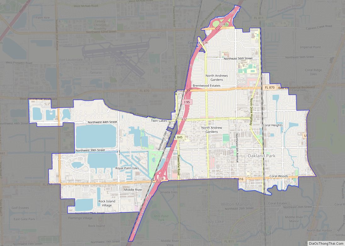
Oakland Park, officially the City of Oakland Park, is a city in Broward County, Florida, United States. As of the 2020 United States Census, the city’s population was 44,229. It is part of the Miami–Fort Lauderdale–West Palm Beach Metropolitan Statistical Area, which was home to 6,166,488 people at the 2020 census. Oakland Park city overview: … Read more

Map of Oak Ridge CDP

Map of Oak Ridge CDP, Florida

Oak Ridge is a census-designated place and unincorporated area in Orange County, Florida, United States. The population was 22,685 at the 2010 census. It is part of the Orlando–Kissimmee–Sanford, Florida Metropolitan Statistical Area. Oak Ridge CDP overview: Name: Oak Ridge CDP LSAD Code: 57 LSAD Description: CDP (suffix) State: Florida County: Orange County Elevation: 89 ft … Read more

Map of Oak Hill city, Florida

Map of Oak Hill city, Florida

Oak Hill is a city in Volusia County, Florida, United States. The population was 1,792 at the 2010 census. Oak Hill city overview: Name: Oak Hill city LSAD Code: 25 LSAD Description: city (suffix) State: Florida County: Volusia County Elevation: 13 ft (4 m) Total Area: 11.19 sq mi (28.98 km²) Land Area: 6.72 sq mi (17.40 km²) Water Area: 4.47 sq mi (11.58 km²) Total … Read more

Map of Ocala city

Map of Ocala city

Ocala (/oʊˈkælə/ oh-KAL-ə) is a city in and the county seat of Marion County within the northern region of Florida, United States. As of the 2020 United States Census, the city’s population was 63,591, making it the 54th most populated city in Florida. Home to over 400 thoroughbred farms and training centers, Ocala was officially … Read more

Map of Oakleaf Plantation CDP

Map of Oakleaf Plantation CDP

Coordinates: 30°10′N 81°50′W / 30.167°N 81.833°W / 30.167; -81.833 Oakleaf Plantation is a planned community in the Jacksonville area located mostly in unincorporated Clay County and partially within the Jacksonville city limits (Duval County). The Clay County portion is a census-designated place, with a 2010 population of 20,315. As of 2020, the population has risen … Read more

Map of Oakland town, Florida

Map of Oakland town, Florida

Oakland is a town in Orange County, Florida, United States. The population was 3,516 at the 2020 Census, representing a growth of 38.5% over the population of 2,538 recorded during the 2010 census. It is part of the Orlando–Kissimmee Metropolitan Statistical Area. Oakland town overview: Name: Oakland town LSAD Code: 43 LSAD Description: town (suffix) … Read more

Map of Ocean Ridge town

Map of Ocean Ridge town

Ocean Ridge is a town in Palm Beach County, Florida, United States. The population was 1,786 at the 2010 census. As of 2018, the population recorded by the U.S. Census Bureau is 1,956. It is part of the Miami Metropolitan Area. Ocean Ridge town overview: Name: Ocean Ridge town LSAD Code: 43 LSAD Description: town … Read more

Map of Ocean City CDP

Map of Ocean City CDP, Florida

Ocean City is a census-designated place (CDP) in Okaloosa County, Florida, United States. The population was 5,594 at the 2000 census. It is part of the Fort Walton Beach–Crestview–Destin Metropolitan Statistical Area. Ocean City CDP overview: Name: Ocean City CDP LSAD Code: 57 LSAD Description: CDP (suffix) State: Florida County: Okaloosa County Elevation: 10 ft (3 m) … Read more

Map of Ocean Breeze town

Map of Ocean Breeze town

Ocean Breeze, formerly Ocean Breeze Park, is a town on the Indian River in Martin County, Florida, United States. Ocean Breeze and Briny Breezes in Palm Beach County are the only two towns in Florida in which all residents live in a mobile home park bearing the name of the town. The population was 301 … Read more

Map of Ojus CDP

Map of Ojus CDP

Ojus is a census-designated place and formerly incorporated town in Miami-Dade County, Florida, United States. The population was 19,673 at the 2020 census, up from 18,036 in 2010. Ojus CDP overview: Name: Ojus CDP LSAD Code: 57 LSAD Description: CDP (suffix) State: Florida County: Miami-Dade County Elevation: 10 ft (3 m) Total Area: 3.16 sq mi (8.18 km²) Land Area: … Read more

Map of Odessa CDP, Florida

Map of Odessa CDP, Florida

Odessa is a census-designated place (CDP) in Pasco County, Florida, United States. The population was 3,173 at the 2000 census and more than doubled to 7,267 in 2010. Northwest of Tampa, Odessa had been an area of open spaces, ranching, and horse properties. More recently it has seen many suburban property developments as Tampa’s population … Read more

Map of Ocoee city

Map of Ocoee city

Ocoee (/əˈkoʊ.i/) is a city in Orange County, Florida, United States. According to the 2019 US Census population estimate, the city had a population of 48,263. It is part of the Orlando–Kissimmee–Sanford, Florida Metropolitan Statistical Area. Ocoee city overview: Name: Ocoee city LSAD Code: 25 LSAD Description: city (suffix) State: Florida County: Orange County Elevation: … Read more