Map of Ormond-by-the-Sea CDP

Map of Ormond-by-the-Sea CDP

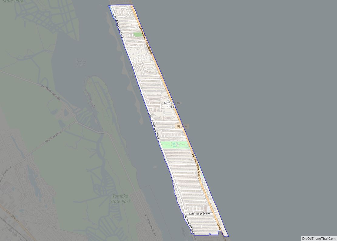
Ormond-by-the-Sea is a census-designated place and an unincorporated town in Volusia County, Florida, United States. The population was 8,430 as of the 2000 census. Ormond-by-the-Sea CDP overview: Name: Ormond-by-the-Sea CDP LSAD Code: 57 LSAD Description: CDP (suffix) State: Florida County: Volusia County Elevation: 13 ft (4 m) Total Area: 2.02 sq mi (5.23 km²) Land Area: 2.02 sq mi (5.22 km²) Water Area: … Read more

Map of Ormond Beach city

Map of Ormond Beach city

Ormond Beach is a city in Volusia County, Florida, United States. The population was 43,080 at the 2020 census. Ormond Beach lies directly north of Daytona Beach and is a principal city of the Deltona–Daytona Beach–Ormond Beach, FL Metropolitan Statistical Area. The city is known as the birthplace of speed, as early adopters of motorized … Read more

Map of Orlovista CDP

Map of Orlovista CDP

Orlo Vista is an unincorporated community and census-designated place in Orange County, Florida, United States. While the spelling “Orlo Vista” is used by the U.S. Postal Service, the community is shown as Orlovista on federal maps. The population of the Orlovista census-designated place was 6,123 at the 2010 census. It is part of the Orlando–Kissimmee … Read more

Map of Oviedo city

Map of Oviedo city

Oviedo (/ˌoʊˈviːdoʊ/ oh-VEE-doh) is a city in Seminole County, Florida, United States. As of the 2010 United States Census, the population was 33,342, representing an increase of 7,026 (26.7%) from the 26,316 counted in the 2000 Census. It is part of the Orlando–Kissimmee–Sanford Metropolitan Statistical Area. Oviedo is known for its historic houses and buildings, … Read more

Map of Otter Creek town

Map of Otter Creek town

Otter Creek is a town in Levy County, Florida, United States. The population was 134 at the 2010 census. Otter Creek town overview: Name: Otter Creek town LSAD Code: 43 LSAD Description: town (suffix) State: Florida County: Levy County Elevation: 26 ft (8 m) Total Area: 1.38 sq mi (3.57 km²) Land Area: 1.36 sq mi (3.52 km²) Water Area: 0.02 sq mi (0.05 km²) Total … Read more

Map of Osprey CDP

Map of Osprey CDP

Osprey is a census-designated place (CDP) in Sarasota County, Florida, United States. The population was 6,100 at the 2010 census. It is part of the Bradenton–Sarasota–Venice Metropolitan Statistical Area. Osprey CDP overview: Name: Osprey CDP LSAD Code: 57 LSAD Description: CDP (suffix) State: Florida County: Sarasota County Elevation: 10 ft (3 m) Total Area: 6.07 sq mi (15.73 km²) Land … Read more

Map of Page Park CDP

Map of Page Park CDP

Page Park is a census-designated place (CDP) in Lee County, Florida, United States. The population was 747 at the 2020 census. It is part of the Cape Coral-Fort Myers, Florida Metropolitan Statistical Area. Page Park CDP overview: Name: Page Park CDP LSAD Code: 57 LSAD Description: CDP (suffix) State: Florida County: Lee County Elevation: 13 ft … Read more

Map of Pace CDP

Map of Pace CDP, Florida

Pace is an unincorporated community in Santa Rosa County, Florida. It is the second largest community in Santa Rosa County, and is a part of the Pensacola Metropolitan Statistical Area. Pace has experienced exponential growth, and has evolved from a small, rural community to a thriving bedroom community of Pensacola with growing residential and commercial … Read more

Map of Pahokee city

Map of Pahokee city

Pahokee is a city located on the shore of Lake Okeechobee in Palm Beach County, Florida, United States. The population was 5,524 in the 2020 census. According to the 2020 U.S. Census, 57% of the residents of Pahokee were African American and 33% were Hispanic or Latino. In 2018, the Mayor, Kenneth W. Babb, as … Read more

Map of Palm Beach Gardens city

Map of Palm Beach Gardens city

Palm Beach Gardens is a city in Palm Beach County in the U.S. state of Florida, 77 miles north of downtown Miami. As of the 2020 United States Census, the population was 59,182. Palm Beach Gardens is a principal city of the Miami metropolitan area, which was home to an estimated 6.1 million people at … Read more

Map of Palatka city

Map of Palatka city

Palatka (/pəˈlætkə/ (listen)) is a city in and the county seat of Putnam County, Florida, United States. The population was 10,558 at the 2010 census. Palatka is the principal city of the Palatka Micropolitan Statistical Area, which is home to 72,893 residents. The city is also home to St. Johns River State College, St. Johns … Read more

Map of Paisley CDP

Map of Paisley CDP, Florida

Paisley is an unincorporated community and census-designated place (CDP) in Lake County, Florida, United States. The population was 818 at the 2010 census, up from 734 at the 2000 census. It is part of the Orlando–Kissimmee Metropolitan Statistical Area. Paisley is the closest community to Boy Scout Camp La-No-Che on the north shore of Lake … Read more