Map of Palm City CDP

Map of Palm City CDP

Palm City is an unincorporated area and census-designated place (CDP) in Martin County, Florida, United States. The population was 25,883 at the 2020 census. It is part of the Port St. Lucie Metropolitan Statistical Area. Palm City CDP overview: Name: Palm City CDP LSAD Code: 57 LSAD Description: CDP (suffix) State: Florida County: Martin County … Read more

Map of Palm Beach town

Map of Palm Beach town

Palm Beach is an incorporated town in Palm Beach County, Florida. Located on a barrier island in east-central Palm Beach County, the town is separated from West Palm Beach and Lake Worth Beach by the Intracoastal Waterway to its west and a small section of the Intracoastal Waterway and South Palm Beach to its south. … Read more

Map of Palm Beach Shores town

Map of Palm Beach Shores town

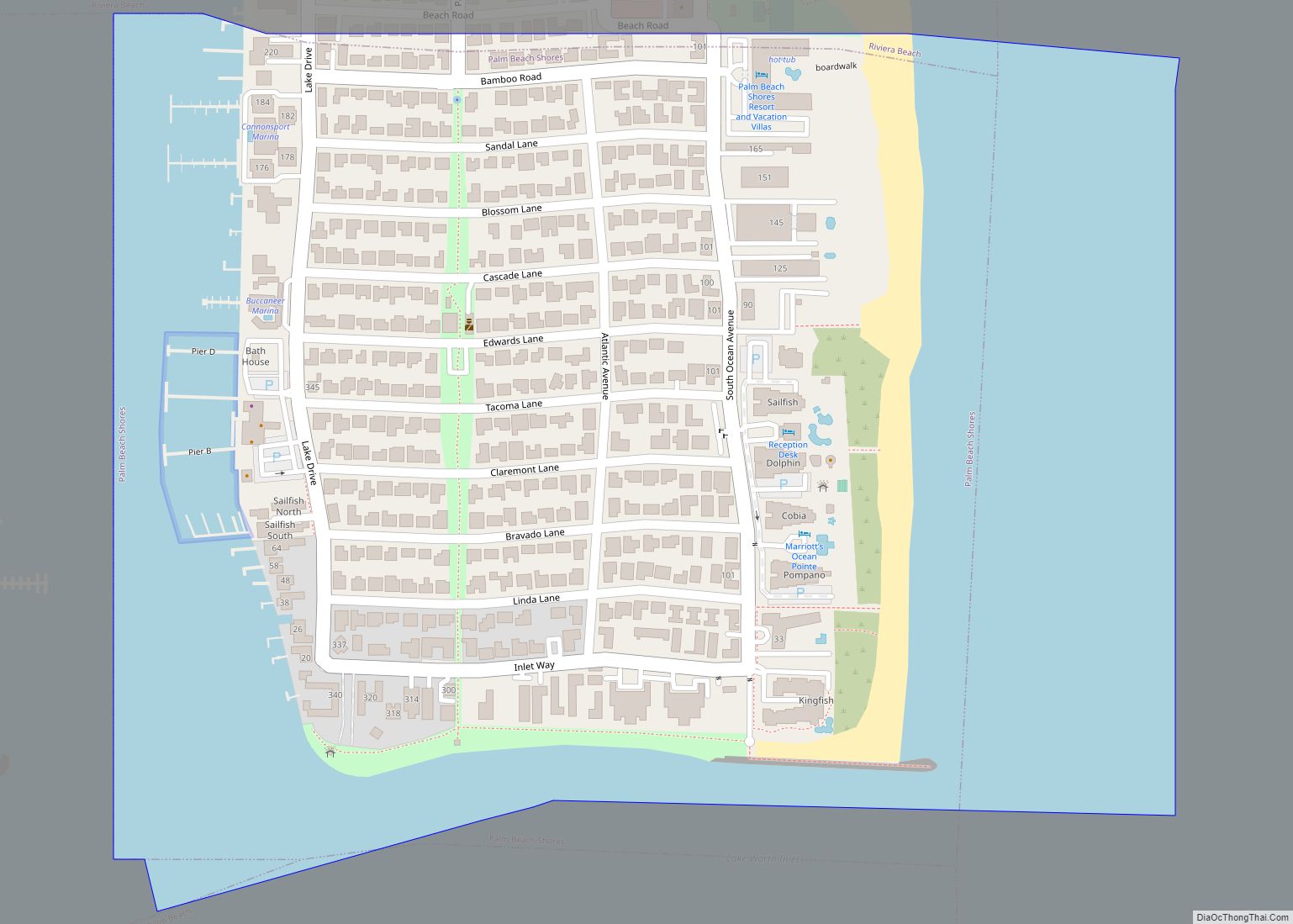
Palm Beach Shores is a town in Palm Beach County, Florida, United States. The population was 1,142 at the 2010 census. As of 2018, the population recorded by the U.S. Census Bureau was 1,264. Palm Beach Shores town overview: Name: Palm Beach Shores town LSAD Code: 43 LSAD Description: town (suffix) State: Florida County: Palm … Read more

Map of Palm River-Clair Mel CDP

Map of Palm River-Clair Mel CDP

Palm River-Clair Mel is a census-designated place (CDP) in Hillsborough County, Florida, United States. The population was 21,024 at the 2010 census, up from 17,589 at the 2000 census. The census area includes the unincorporated communities of Clair-Mel City and Palm River. The ZIP code for Palm River-Clair Mel is 33619. Palm River-Clair Mel CDP … Read more

Map of Palm Harbor CDP

Map of Palm Harbor CDP

Palm Harbor is a census-designated place and unincorporated community in Pinellas County, Florida, United States. As of the 2016 American Community Survey, the CDP had a population of 60,236. Palm Harbor CDP overview: Name: Palm Harbor CDP LSAD Code: 57 LSAD Description: CDP (suffix) State: Florida County: Pinellas County Elevation: 49 ft (15 m) Total Area: 28.10 sq mi … Read more

Map of Palm Coast city

Map of Palm Coast city

Palm Coast is a city in Flagler County, Florida. As of the 2010 United States Census, the population was 75,180, more than twice the 32,832 counted in 2000. The population was estimated to be 89,800 in 2019. It is the most populous city in Flagler County. Palm Coast is part of the Deltona–Daytona Beach–Ormond Beach, … Read more

Map of Palm Springs village, Florida

Map of Palm Springs village, Florida

Palm Springs is a village in Palm Beach County, Florida, United States, situated approximately 61 mi (98 km) north of Miami. The village’s name was likely derived from the resort city of Palm Springs, California. Located in the east-central part of the county, Palm Springs is situated north of Atlantis, east of Greenacres, west of Lake Clarke … Read more

Map of Palm Springs North CDP

Map of Palm Springs North CDP

Palm Springs North is an unincorporated community and census-designated place (CDP) in Miami-Dade County, Florida, United States. The population was 5,030 at the 2020 census. Palm Springs North CDP overview: Name: Palm Springs North CDP LSAD Code: 57 LSAD Description: CDP (suffix) State: Florida County: Miami-Dade County Elevation: 8 ft (2 m) Total Area: 1.00 sq mi (2.59 km²) Land … Read more

Map of Palm Shores town

Map of Palm Shores town

Palm Shores is a town in Brevard County, Florida. The population was 900 at the 2010 United States Census. It is part of the Palm Bay–Melbourne–Titusville Metropolitan Statistical Area. Palm Shores town overview: Name: Palm Shores town LSAD Code: 43 LSAD Description: town (suffix) State: Florida County: Brevard County Elevation: 13 ft (4 m) Total Area: 0.60 sq mi … Read more

Map of Palmetto Estates CDP

Map of Palmetto Estates CDP

Palmetto Estates is an unincorporated area and census-designated place (CDP) in Miami-Dade County, Florida, United States. The population was 13,498 at the 2020 census. Palmetto Estates CDP overview: Name: Palmetto Estates CDP LSAD Code: 57 LSAD Description: CDP (suffix) State: Florida County: Miami-Dade County Elevation: 10 ft (3 m) Total Area: 2.21 sq mi (5.71 km²) Land Area: 2.16 sq mi (5.59 km²) … Read more

Map of Palmetto Bay village

Map of Palmetto Bay village

Palmetto Bay is a suburban incorporated village in Miami-Dade County, Florida, United States. The population was 24,439 as of the 2020 US census. Palmetto Bay includes three neighborhoods that were former census-designated places, Cutler, Rockdale and East Perrine. Palmetto Bay village overview: Name: Palmetto Bay village LSAD Code: 47 LSAD Description: village (suffix) State: Florida … Read more

Map of Palm Valley CDP

Map of Palm Valley CDP, Florida

Palm Valley is a census-designated place (CDP) in St. Johns County, Florida, United States. The population was 19,860 at the 2000 census. Palm Valley CDP overview: Name: Palm Valley CDP LSAD Code: 57 LSAD Description: CDP (suffix) State: Florida County: St. Johns County Elevation: 7 ft (2 m) Total Area: 13.61 sq mi (35.25 km²) Land Area: 12.20 sq mi (31.59 km²) Water … Read more