Palm Springs is a village in Palm Beach County, Florida, United States, situated approximately 61 mi (98 km) north of Miami. The village’s name was likely derived from the resort city of Palm Springs, California. Located in the east-central part of the county, Palm Springs is situated north of Atlantis, east of Greenacres, west of Lake Clarke Shores and Lake Worth Beach, and southwest of West Palm Beach. The 2010 United States census recorded the village’s population at 18,928, which increased to 26,890 in the 2020 census. Palm Springs is also located within the Miami metropolitan area, which had a population of approximately 6,138,333 people as of 2020.
William A. Boutwell operated a dairy farm on 5 acres (2.0 ha) of land in modern-day Palm Springs beginning in 1927, which expanded to about 700 acres (280 ha) prior to his retirement in 1956. One year later, the Florida Legislature approved a charter establishing the village of Palm Springs as Palm Beach County’s 30th municipality on May 31, 1957. At the time of incorporation, the village consisted only of farmland, a dairy barn, and no permanent residents. Within two years, around 800 homes had been built, and four schools were constructed in or near Palm Springs between 1959 and 1970. The first village hall was erected in 1960.
Palm Springs has been expanding through annexation since 1998, more than doubling the village’s land area and population within a few decades. Also around that time, the village government began planning for a new municipal complex, which opened in the mid-2000s. By 2010, Palm Springs became the first municipality in Palm Beach County in which a majority of its residents are of Hispanic or Latino ancestry. The village is also the home of the Fulton-Holland Educational Services Center, the headquarters of the School District of Palm Beach County.
| Name: | Palm Springs village |
|---|---|
| LSAD Code: | 47 |
| LSAD Description: | village (suffix) |
| State: | Florida |
| County: | Palm Beach County |
| Incorporated: | May 31, 1957 (1957-05-31) |
| Elevation: | 10 ft (3 m) |
| Total Area: | 4.25 sq mi (11.02 km²) |
| Land Area: | 4.21 sq mi (10.90 km²) |
| Water Area: | 0.05 sq mi (0.12 km²) |
| Total Population: | 26,890 |
| Population Density: | 6,391.73/sq mi (2,467.75/km²) |
| Area code: | 561 |
| FIPS code: | 1254450 |
| GNISfeature ID: | 0293892 |
| Website: | https://www.vpsfl.org/ |
Online Interactive Map
Click on ![]() to view map in "full screen" mode.
to view map in "full screen" mode.
Palm Springs location map. Where is Palm Springs village?


History
Residents of Lake Worth (now the city of Lake Worth Beach) proposed to town commissioners in May 1922 that a municipal country club and golf course be constructed to attract winter tourists. According to The Lake Worth Herald, the facility would be located west of the town at “Section 19, Township 44 South, Range 43 East”, an area that is now part of Palm Springs. However, a referendum held in the following month rejected the proposal by a narrow margin. Instead, Lake Worth’s municipal golf course opened along the Intracoastal Waterway in November 1926. Commissioners nonetheless approved an ordinance that month to annex 1,800 acres (730 ha) of land west of the city’s boundaries, extending as far as 660 ft (200 m) west of Military Trail; this included parts of modern-day Palm Springs.
In 1927, then-Lake Worth vice mayor William A. Boutwell, who moved to the area from Massachusetts earlier in the 1920s and owned a grocery store and masonry supply company in the city, began dairy farming on 5 acres (2.0 ha) of land in modern-day Palm Springs – in addition to the farmland he owned in Lake Worth. Over time, his dairy farm expanded to occupy approximately 700 acres (280 ha), while the Boutwell Dairy herd increased to more than 1,000 Guernsey cattle in the vicinity of Congress Avenue and Forest Hill Boulevard (then named Selby Road) at its peak, becoming one of the largest dairy farms in Florida. Additionally, William A. Boutwell invented half-and-half creamer in Lake Worth. He retired in 1956, while his family sold the remaining farmland and livestock by 1965.
By 1957, Moore Associates Development Group of Miami created a plan to develop a new community west of Lake Worth on the land formerly used by the Boutwell dairy farm, at a townsite consisting of about 700 acres (280 ha) of farmland and only one structure, a large dairy barn. Consequently, Florida House of Representatives member Ralph Blank Jr. of Palm Beach County introduced legislation that same year to establish the village of Palm Springs. The bill passed unanimously and Palm Springs was chartered on May 31, 1957. The village was likely named after the resort city of Palm Springs, California. Moore Associates Development Group founder James E. Moore became the first mayor of Palm Springs, while other first officeholders included tax collector Bernard Jaffe, town counsel Rome Amari, and village council members Robert Levinson, William R. Moore, Buck Wentz, and Sid Zwirn.
To transform the pastures into land suitable for development, work crews shifted millions of tons of muck and sand to enhance both drainage and landscape appearances. Another early project was the creation of a water and sewage system, which cost approximately $1.5 million. By August 1958, about 800 homes had been built. Rapid population growth necessitated the construction of four schools in and near Palm Springs between 1959 and 1970, beginning with Palm Springs Elementary School in September 1959. Palm Springs was a 1959 recipient of the Florida Illustrated Magazine’s community builders award. In the first few years of its existence, the village government functioned in the remodeled dairy barn, located at 153 Henthorne Drive, briefly sharing the building with Christ Community Church. However, construction soon began on a nearly 8,000 sq ft (740 m) village hall, which opened in February 1960. The 1960 census, the first conducted since the establishment of Palm Springs, recorded a population of 2,503 people. A 1962 profile in The Palm Beach Post reported that the village had 38 paved roads, while about 1,300 building permits had been approved over the past five years.
The population of the village increased significantly in the 1970s, nearly doubling from 4,340 in the 1970 census to 8,166 in the 1980 census. On November 11, 1978, the Jeanette J. Guerty Palm Springs Library opened. Originally 6,000 sq ft (560 m) in size, the building has since been enlarged, first in the mid-1980s. The village’s original boundaries remained mostly unchanged for about four decades. However, in 1997, the village council adopted a plan for expanding Palm Springs. Under the plan, future annexation included all areas west to Military Trail from its boundaries at the time, between Lake Worth Road and north of Forest Hill Boulevard; and all areas east of the present boundaries to Florida Mango Road. The annexation plan was expected to increase the population of Palm Springs by another 10,000 residents, roughly twice the population in 1997. Also in the late 1990s, the village council began planning to renovate the original municipal complex after residents approved a bond referendum in 1999.
Consequently, a new village hall opened in July 2003 – a two-story, 24,000 sq ft (2,200 m) structure, approximately thrice as large as the original village hall. Thereafter, the newly expanded library and public safety building opened in 2004 and 2005, respectively. Also in 2005, Hurricane Wilma destroyed 5 homes and damaged 2,462 others to some extent in Palm Springs, including substantial impact to 460 multi-family residences, more than in any other municipality in Palm Beach County. However, damage from Wilma totaled only $6.1 million, including $3 million to businesses, $2.5 million to residences, and $600,000 to government properties. In 2007, Palm Springs observed its 50th anniversary of incorporation alongside Independence Day celebrations. Beginning with the 2010 census, a majority of residents of the village identified as Hispanic or Latino.
Palm Springs Road Map

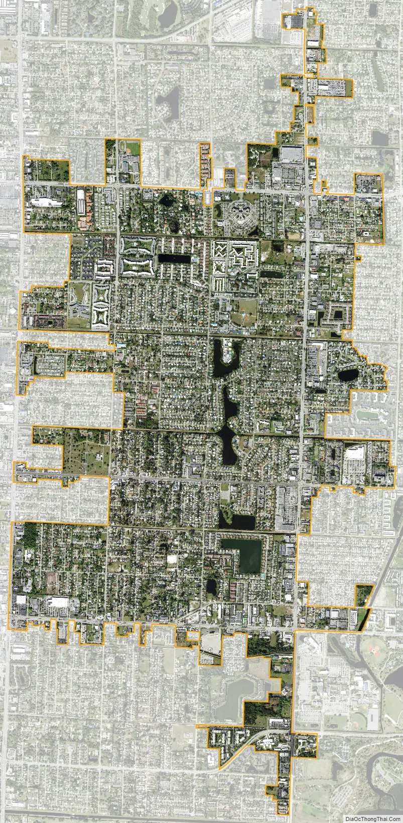
Palm Springs city Satellite Map
Geography
Palm Springs is located at 26°38′09″N 080°05′46″W / 26.63583°N 80.09611°W / 26.63583; -80.09611 (26.6359, –080.0936) in east-central Palm Beach County. The village is situated adjacent to Greenacres, Lake Clarke Shores, Lake Worth Beach, and West Palm Beach. Palm Springs has been expanding by annexation since 1998. The United States Census Bureau reported in 2000 that Palm Springs had a total area of 1.65 square miles (4.3 km), of which 1.6 square miles (4.1 km) was land and 0.05 square miles (0.13 km) was water. As of 2020, the village has a total area of 4.25 square miles (11.0 km), of which 4.21 square miles (10.9 km) is land and 0.05 square miles (0.13 km) is water.
The original village townsite includes a chain of artificial north-to-south oriented lakes linked to canals, engineered in 1957 as a mechanism to promote drainage. Geologically, Palm Springs is located within the Anastasia Formation region, which dominates far eastern Palm Beach County. This type of geological formation is composed primarily of coquina, sand, and sandy limestone. The average elevation of Palm Springs is 10 ft (3.0 m).
See also
Map of Florida State and its subdivision:- Alachua
- Baker
- Bay
- Bradford
- Brevard
- Broward
- Calhoun
- Charlotte
- Citrus
- Clay
- Collier
- Columbia
- Desoto
- Dixie
- Duval
- Escambia
- Flagler
- Franklin
- Gadsden
- Gilchrist
- Glades
- Gulf
- Hamilton
- Hardee
- Hendry
- Hernando
- Highlands
- Hillsborough
- Holmes
- Indian River
- Jackson
- Jefferson
- Lafayette
- Lake
- Lee
- Leon
- Levy
- Liberty
- Madison
- Manatee
- Marion
- Martin
- Miami-Dade
- Monroe
- Nassau
- Okaloosa
- Okeechobee
- Orange
- Osceola
- Palm Beach
- Pasco
- Pinellas
- Polk
- Putnam
- Saint Johns
- Saint Lucie
- Santa Rosa
- Sarasota
- Seminole
- Sumter
- Suwannee
- Taylor
- Union
- Volusia
- Wakulla
- Walton
- Washington
- Alabama
- Alaska
- Arizona
- Arkansas
- California
- Colorado
- Connecticut
- Delaware
- District of Columbia
- Florida
- Georgia
- Hawaii
- Idaho
- Illinois
- Indiana
- Iowa
- Kansas
- Kentucky
- Louisiana
- Maine
- Maryland
- Massachusetts
- Michigan
- Minnesota
- Mississippi
- Missouri
- Montana
- Nebraska
- Nevada
- New Hampshire
- New Jersey
- New Mexico
- New York
- North Carolina
- North Dakota
- Ohio
- Oklahoma
- Oregon
- Pennsylvania
- Rhode Island
- South Carolina
- South Dakota
- Tennessee
- Texas
- Utah
- Vermont
- Virginia
- Washington
- West Virginia
- Wisconsin
- Wyoming


