Map of Panacea CDP

Map of Panacea CDP

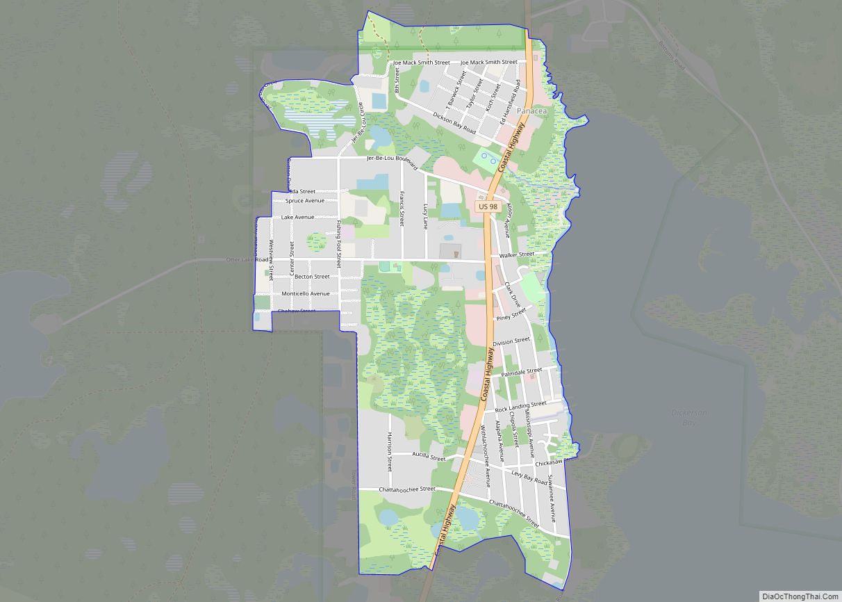
Panacea is an unincorporated community in Wakulla County, Florida, United States. Panacea CDP overview: Name: Panacea CDP LSAD Code: 57 LSAD Description: CDP (suffix) State: Florida County: Wakulla County Founded: 1895 Elevation: 7 ft (2 m) Total Area: 816 ZIP code: 32346 Area code: 850 FIPS code: 1254625 Website: www.visitpanacea.com Online Interactive Map Panacea online map. Source: … Read more

Map of Palmona Park CDP

Map of Palmona Park CDP

Palmona Park is a census-designated place (CDP) in Lee County, Florida, United States. The population was 1,146 at the 2010 census, down from 1,353 at the 2000 census. It is part of the Cape Coral-Fort Myers, Florida Metropolitan Statistical Area. Palmona Park CDP overview: Name: Palmona Park CDP LSAD Code: 57 LSAD Description: CDP (suffix) … Read more

Map of Palmetto city

Map of Palmetto city, Florida

Palmetto is a city in Manatee County, Florida, United States. As of the 2020 census, the population was listed as 13,323. It is part of the North Port–Sarasota–Bradenton metropolitan statistical area. Palmetto city overview: Name: Palmetto city LSAD Code: 25 LSAD Description: city (suffix) State: Florida County: Manatee County Elevation: 12 ft (4 m) Total Area: 5.83 sq mi … Read more

Map of Paradise Heights CDP

Map of Paradise Heights CDP

Paradise Heights is a census-designated place and an unincorporated area in Orange County, Florida, United States. The population was 1,215 at the 2010 census. It is part of the Orlando–Kissimmee Metropolitan Statistical Area. Paradise Heights CDP overview: Name: Paradise Heights CDP LSAD Code: 57 LSAD Description: CDP (suffix) State: Florida County: Orange County Elevation: 98 ft … Read more

Map of Panama City city

Map of Panama City

Panama City is a city in and the county seat of Bay County, Florida, United States. Located along U.S. Highway 98 (US 98), it is the largest city between Tallahassee and Pensacola. It is also the most populated city of the Panama City–Lynn Haven, Florida metropolitan statistical area. Panama City was severely damaged when Hurricane Michael … Read more

Map of Panama City Beach city

Map of Panama City Beach city

Panama City Beach is a resort town in Bay County, Florida, United States, on the Gulf of Mexico coast. As of the 2010 census it had a population of 12,018. The city is often referred to under the umbrella term of “Panama City“. Panama City Beach’s slogan is “The World’s Most Beautiful Beaches” due to … Read more

Map of Pasadena Hills CDP

Map of Pasadena Hills CDP, Florida

Pasadena Hills is an unincorporated community and census-designated place in Pasco County, Florida, United States. Its population was 7,570 as of the 2010 census. The community was originally planned in 1925. Pasadena Hills CDP overview: Name: Pasadena Hills CDP LSAD Code: 57 LSAD Description: CDP (suffix) State: Florida County: Pasco County Elevation: 187 ft (57 m) Total … Read more

Map of Parkland city

Map of Parkland city, Florida

Parkland is a suburban city, 42 miles northwest of Miami, in northern Broward County, Florida, United States. As of the 2020 census, the population of Parkland was 34,670. Parkland is part of the Miami metropolitan area, which was home to 6,166,488 people in 2020. Parkland’s zoning laws are designed to protect the “park-like” character of … Read more

Map of Parker city, Florida

Map of Parker city, Florida

Parker is a city in Bay County, Florida, United States. As of the 2010 census it had a population of 4,317. It is part of the Panama City–Lynn Haven–Panama City Beach Metropolitan Statistical Area. Parker city overview: Name: Parker city LSAD Code: 25 LSAD Description: city (suffix) State: Florida County: Bay County Incorporated: 1967 Elevation: … Read more

Map of Patrick AFB CDP

Map of Patrick AFB CDP

Patrick AFB CDP overview: Name: Patrick AFB CDP LSAD Code: 57 LSAD Description: CDP (suffix) State: Florida County: Brevard County FIPS code: 1255375 Online Interactive Map Patrick AFB online map. Source: Basemap layers from Google Map, Open Street Map (OSM), Arcgisonline, Wmflabs. Boundary Data from Database of Global Administrative Areas. Patrick AFB location map. Where … Read more

Map of Pea Ridge CDP, Florida

Map of Pea Ridge CDP, Florida

Pea Ridge is community in Santa Rosa County, Florida, United States, located along U.S. Highway 90, east of Pace. It was designated a Census-designated place (CDP) by the Census Bureau after the 2010 census. The CDP had a total area of 2.82 square miles (7.3 km) and a population 3,587 in 2010. Pea Ridge is located … Read more

Map of Paxton town, Florida

Map of Paxton town, Florida

Paxton is a town in Walton County, Florida, United States. The population was 644 as of the 2010 census. Located near Britton Hill on the Alabama–Florida state line, the town has the highest elevation of any in Florida. Paxton town overview: Name: Paxton town LSAD Code: 43 LSAD Description: town (suffix) State: Florida County: Walton … Read more