Map of Sunset CDP, Florida

Map of Sunset CDP, Florida

Sunset is a census-designated place (CDP) in Miami-Dade County, Florida, United States. The population was 15,912 at the 2020 census. The U.S. Postal Service uses the ZIP Codes of 33173 and 33183 for Sunset. Sunset CDP overview: Name: Sunset CDP LSAD Code: 57 LSAD Description: CDP (suffix) State: Florida County: Miami-Dade County Elevation: 7 ft (2 m) … Read more

Map of Sunrise city, Florida

Map of Sunrise city, Florida

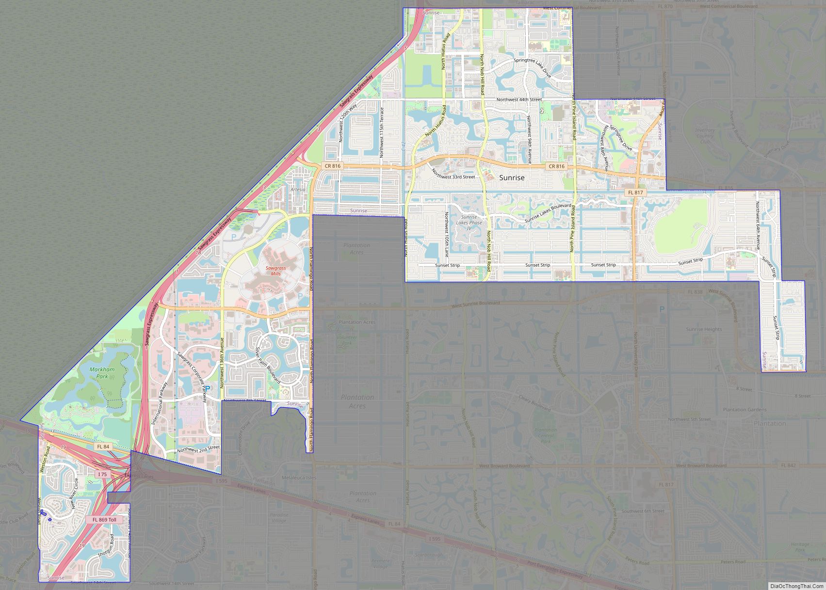
Sunrise is a city in central-western Broward County, Florida, United States, and is a principal city of the Miami metropolitan area. As of the 2020 census, the city had a total population of 97,335. Sunrise was incorporated in 1961 and founded by Norman Johnson, a developer whose Upside-Down House attracted buyers to what was then … Read more

Map of Sunny Isles Beach city

Map of Sunny Isles Beach city

Sunny Isles Beach (SIB, officially the City of Sunny Isles Beach) is a city located on a barrier island in northeast Miami-Dade County, Florida, United States. The city is bounded by the Atlantic Ocean on the east and the Intracoastal Waterway on the west. As of the 2020 census, it had a population of 22,342. … Read more

Map of Taft CDP, Florida

Map of Taft CDP, Florida

Taft is a census-designated place and an unincorporated area in Orange County, Florida, United States. The population was 2,205 at the 2010 census. It is part of the Orlando–Kissimmee Metropolitan Statistical Area. Taft CDP overview: Name: Taft CDP LSAD Code: 57 LSAD Description: CDP (suffix) State: Florida County: Orange County Elevation: 95 ft (29 m) Total Area: … Read more

Map of Sweetwater city

Map of Sweetwater city, Florida

Sweetwater is a city in Miami-Dade County, Florida, United States. As of the 2020 census, the population was 19,363, up from 13,499 in 2010. Sweetwater city overview: Name: Sweetwater city LSAD Code: 25 LSAD Description: city (suffix) State: Florida County: Miami-Dade County Incorporated: October 10, 1941 Total Area: 2.30 sq mi (10.96 km²) Land Area: 2.19 sq mi (5.68 km²) Water … Read more

Map of Surfside town

Map of Surfside town

Surfside is a town in Miami-Dade County, Florida, United States. The population was 5,689 as of the 2020 census. Surfside is a primarily residential beachside community, with several multistory condominium buildings adjacent to Surfside Beach on the Atlantic Ocean. The town is bordered on the south by the North Beach neighborhood of Miami Beach, on … Read more

Map of Tangelo Park CDP

Map of Tangelo Park CDP

Tangelo Park is a census-designated place and an unincorporated area in Orange County, Florida, United States. The population was 2,231 at the 2010 census. It is part of the Orlando–Kissimmee Metropolitan Statistical Area. Tangelo Park CDP overview: Name: Tangelo Park CDP LSAD Code: 57 LSAD Description: CDP (suffix) State: Florida County: Orange County Elevation: 95 ft … Read more

Map of Tamiami CDP

Map of Tamiami CDP

Tamiami is a census-designated place (CDP) in Miami-Dade County, Florida, United States. The population was 54,212 at the 2020 census. Tamiami CDP overview: Name: Tamiami CDP LSAD Code: 57 LSAD Description: CDP (suffix) State: Florida County: Miami-Dade County Elevation: 7 ft (2 m) Total Area: 7.43 sq mi (19.24 km²) Land Area: 7.05 sq mi (18.25 km²) Water Area: 0.38 sq mi (0.98 km²) Total Population: … Read more

Map of Tamarac city

Map of Tamarac city

Tamarac is a city in Broward County, Florida, United States. At the 2020 census, the city had a population of 71,897. It is part of the Miami metropolitan area, which was home to an estimated 6,012,331 people in 2015. Tamarac city overview: Name: Tamarac city LSAD Code: 25 LSAD Description: city (suffix) State: Florida County: … Read more

Map of Tavares city

Map of Tavares city

Tavares (/tʌvˈɛəriz/, tuh-VAIR-ees) is a city and the county seat of Lake County, Florida. The population at the 2020 census was 19,003, and in 2019 the population was estimated to be 17,749. It is part of the Orlando–Kissimmee–Sanford Metropolitan Statistical Area. Tavares city overview: Name: Tavares city LSAD Code: 25 LSAD Description: city (suffix) State: … Read more

Map of Tarpon Springs city

Map of Tarpon Springs city

Tarpon Springs is a city in Pinellas County, Florida, United States. The population was 23,484 at the 2010 census. Downtown Tarpon Springs has long been a focal point and is undergoing beautification. Tarpon Springs has the highest percentage of Greek Americans of any city in the US. Tarpon Springs city overview: Name: Tarpon Springs city … Read more

Map of Tangerine CDP

Map of Tangerine CDP

Tangerine is a census-designated place (CDP) in Orange County, Florida, United States. The population was 2,865 at the 2010 census. It is part of the Orlando–Kissimmee Metropolitan Statistical Area. Tangerine CDP overview: Name: Tangerine CDP LSAD Code: 57 LSAD Description: CDP (suffix) State: Florida County: Orange County Elevation: 151 ft (46 m) Total Area: 5.29 sq mi (13.69 km²) Land … Read more