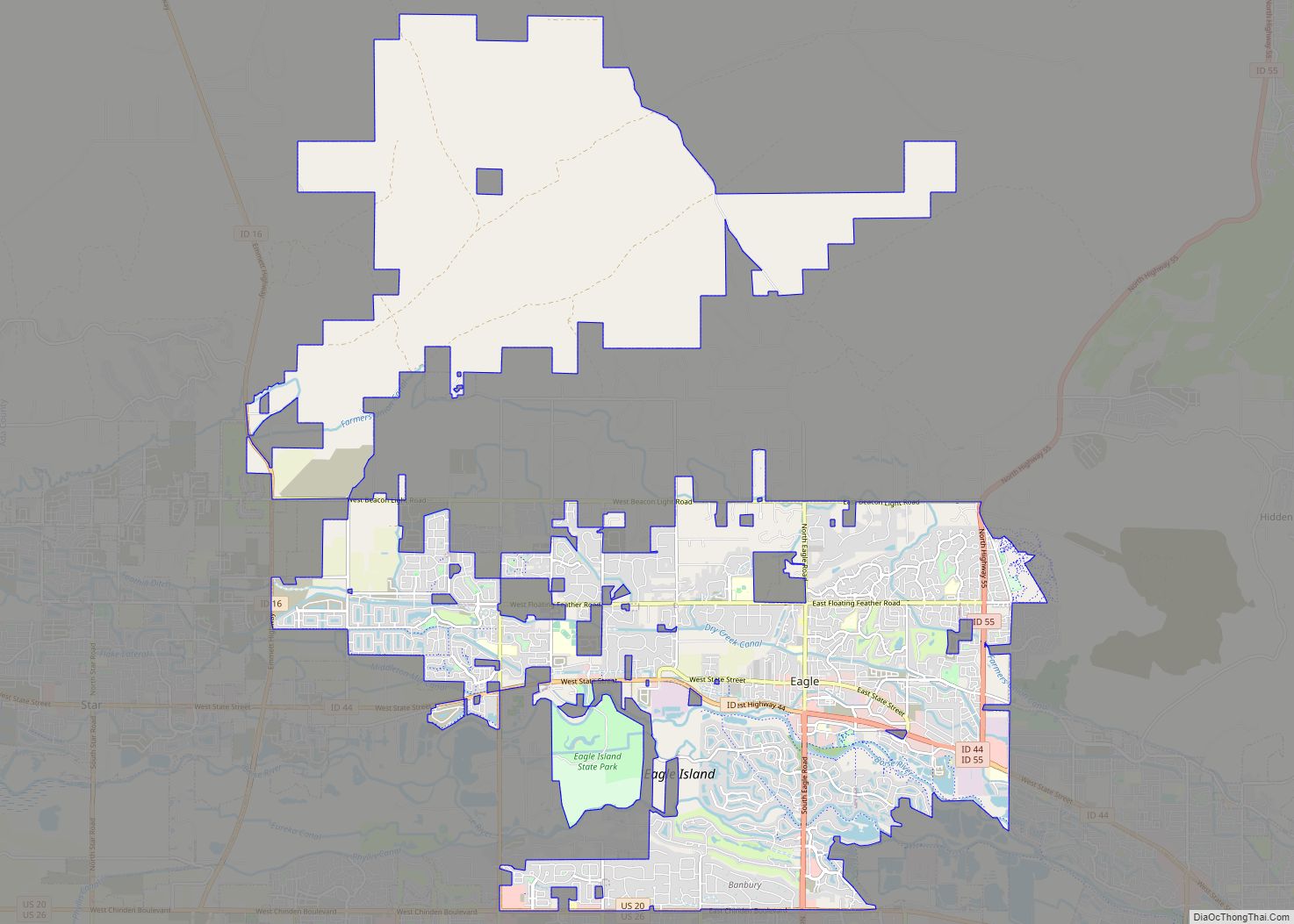
Map of Eden city

Map of Eden city, Idaho

Eden is a city in Jerome County, Idaho, United States. The population was 405 at the 2010 census. It is part of the Twin Falls, Idaho Metropolitan Statistical Area. Eden city overview: Name: Eden city LSAD Code: 25 LSAD Description: city (suffix) State: Idaho County: Jerome County Elevation: 3,963 ft (1,208 m) Total Area: 0.31 sq mi (0.81 km²) Land … Read more

Map of Emmett city

Map of Emmett city, Idaho

Emmett is a city in Gem County, Idaho, United States. The population was 6,557 at the 2010 census, up from 5,490 in 2000. It is the county seat and the only city in the county. Emmett is part of the Boise−Nampa, Idaho Metropolitan Statistical Area. Emmett city overview: Name: Emmett city LSAD Code: 25 LSAD … Read more

Map of Elk River city

Map of Elk River city, Idaho

Elk River is a city in the northwestern United States in Clearwater County, Idaho. The population was 125 at the 2010 census, down from 156 in 2000. It is accessed from State Highway 8 from Bovill, to the west in adjacent Latah County. Formerly the site of a Potlatch sawmill, it was phased out after … Read more

Map of Elk City CDP

Map of Elk City CDP, Idaho

Elk City is a census-designated place in Idaho County, Idaho, United States. As of the 2020 census, its population was 170. Elk City CDP overview: Name: Elk City CDP LSAD Code: 57 LSAD Description: CDP (suffix) State: Idaho County: Idaho County Elevation: 4,006 ft (1,221 m) Total Area: 2.510 sq mi (6.50 km²) Land Area: 2.506 sq mi (6.49 km²) Water Area: 0.004 sq mi … Read more

Map of Fernan Lake Village city

Map of Fernan Lake Village city

Fernan Lake Village is a city in Kootenai County, Idaho, United States. The population was 169 at the 2010 census. Fernan Lake Village city overview: Name: Fernan Lake Village city LSAD Code: 25 LSAD Description: city (suffix) State: Idaho County: Kootenai County Incorporated: July 15, 1957 Elevation: 2,139 ft (652 m) Total Area: 0.08 sq mi (0.20 km²) Land Area: … Read more

Map of Ferdinand city

Map of Ferdinand city, Idaho

Ferdinand is a city in Idaho County, Idaho, United States. The population was 159 at the 2010 census, up from 145 in 2000. At the southern end of the Nez Perce Indian Reservation, it was founded by F.M. Bieker shortly after the reservation was opened for settlement in 1895. It was named after Ferdinand, Indiana, … Read more

Map of Fairfield city, Idaho

Map of Fairfield city, Idaho

Fairfield is the county seat of and the only village in Camas County, Idaho. The population was 410 at the time of 2010 census, nearly half of the rural county’s population. Fairfield city overview: Name: Fairfield city LSAD Code: 25 LSAD Description: city (suffix) State: Idaho County: Camas County Elevation: 5,066 ft (1,544 m) Total Area: 0.88 sq mi … Read more

Map of Fort Hall CDP

Map of Fort Hall CDP

Fort Hall is a census-designated place (CDP) in the southeastern part of the U.S. state of Idaho which is split between Bannock County in the south and Bingham County in the north. It is located on the Fort Hall Indian Reservation along the Snake River north of Pocatello and near the site of the original … Read more

Map of Firth city

Map of Firth city, Idaho

Firth is a city in Bingham County, Idaho, United States. The population was 477 at the 2010 census. Firth city overview: Name: Firth city LSAD Code: 25 LSAD Description: city (suffix) State: Idaho County: Bingham County Elevation: 4,570 ft (1,393 m) Total Area: 0.57 sq mi (1.48 km²) Land Area: 0.57 sq mi (1.48 km²) Water Area: 0.00 sq mi (0.00 km²) Total Population: 477 Population … Read more

Map of Filer city

Map of Filer city

Filer (FĪ-ler) is a city in Twin Falls County, Idaho, United States. The population was 2,508 at the 2010 census. Filer is located just west of the intersection of U.S. Routes 93 and 30. Filer city overview: Name: Filer city LSAD Code: 25 LSAD Description: city (suffix) State: Idaho County: Twin Falls County Founded: 1906 … Read more

Map of Garden City, Idaho

Map of Garden City, Idaho

Garden City is a city in Ada County, Idaho. The population was 12,316 at the time of the 2020 census. Garden City is nearly surrounded by Boise but retains a separate municipal government. Garden City was named for gardens raised by Chinese immigrants who lived in the area. The name of the city’s only main … Read more

Map of Fruitland city, Idaho

Map of Fruitland city, Idaho

Fruitland is a city along the Snake and Payette rivers in Payette County, Idaho, United States. It lies along U.S. Route 95 in the Treasure Valley of southwest Idaho, about 50 miles (80 km) west of Boise on the border with Oregon. It is part of the Ontario Micropolitan Area. Fruitland is named after apple orchards … Read more