Map of Warren village, Illinois

Map of Warren village, Illinois

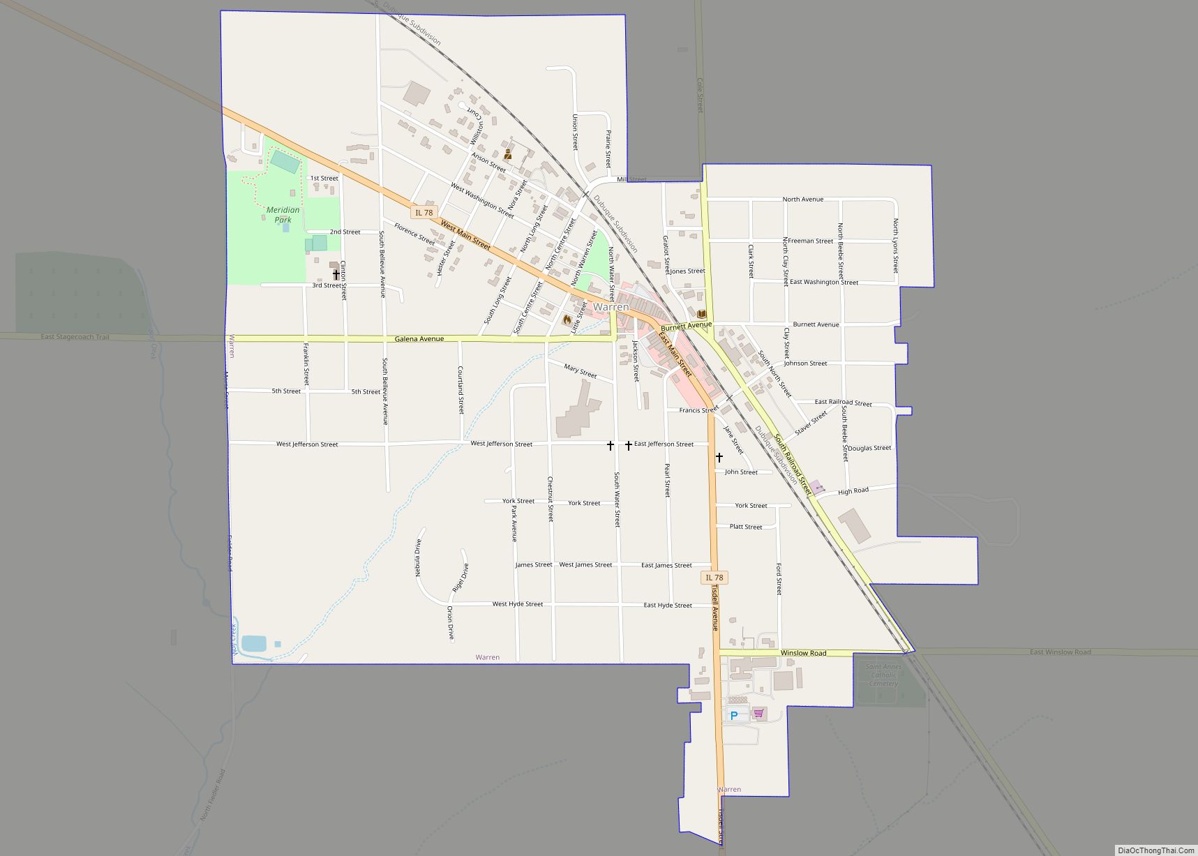
Warren is a village in Jo Daviess County, Illinois, United States. The population was 1,323 at the 2020 census, down from 1,428 at the 2010 census. Warren was named after Warren Burnett, the first male child born at the site. Warren village overview: Name: Warren village LSAD Code: 47 LSAD Description: village (suffix) State: Illinois … Read more

Map of Warsaw city

Map of Warsaw city, Illinois

Warsaw is a city in Hancock County, Illinois, United States. The population was 1,607 at the 2010 census, a decline from 1,793 in 2000. The city is notable for its historic downtown and the Warsaw Brewery, which operated for more than 100 years beginning in 1861 and, after renovation, reopened as a bar, restaurant and … Read more

Map of Warrenville city

Map of Warrenville city, Illinois

Warrenville is a village in DuPage County, Illinois, United States. The population was 13,553 at the 2020 census. Warrenville is a far west suburb of Chicago in the Illinois Technology and Research Corridor, and is just north of I-88. Warrenville city overview: Name: Warrenville city LSAD Code: 25 LSAD Description: city (suffix) State: Illinois County: … Read more

Map of Washington Park village, Illinois

Map of Washington Park village, Illinois

Washington Park is a village in St. Clair County, Illinois, United States. The population was 4,196 as of the 2010 census, down from 5,345 in 2000. Washington Park village overview: Name: Washington Park village LSAD Code: 47 LSAD Description: village (suffix) State: Illinois County: St. Clair County Founded: December 19, 1923 Elevation: 423 ft (129 m) Total … Read more

Map of Washburn village, Illinois

Map of Washburn village, Illinois

Washburn is a village mostly in Woodford County, with a small northerly portion in Marshall County, Illinois, United States. The population was 1,032 at the 2020 census. It is part of the Peoria Metropolitan Statistical Area. Washburn village overview: Name: Washburn village LSAD Code: 47 LSAD Description: village (suffix) State: Illinois County: Marshall County, Woodford … Read more

Map of Wataga village

Map of Wataga village

Wataga is a village in Knox County, Illinois, United States. The population was 843 at the 2010 census, down from 857 in 2000. It is part of the Galesburg Micropolitan Statistical Area. Wataga village overview: Name: Wataga village LSAD Code: 47 LSAD Description: village (suffix) State: Illinois County: Knox County Elevation: 830 ft (250 m) Total Area: … Read more

Map of Washington city, Illinois

Map of Washington city, Illinois

Washington is a city in Tazewell County, Illinois, United States. Washington is on U.S. Route 24 and Illinois Route 8, northeast of East Peoria. The population was 15,134 at the 2010 census, a 39.6 percent increase over 2000. It is a suburb of Peoria and is part of the Peoria Metropolitan Statistical Area. Washington city … Read more

Map of Waterman village

Map of Waterman village

Waterman is a village in DeKalb County, Illinois, United States. The population was 1,433 at the 2020 census. The village was known for the “Waterman and Western” train line that operates in Lion’s Club Park. This 1/3 scale train line comprises a 1/2 mile train line circling the park and is a hobby of a … Read more

Map of Waterloo city, Illinois

Map of Waterloo city, Illinois

Waterloo is a city in and county seat of Monroe County, Illinois, United States. The population was 11,013 at the 2020 census, up from 9,811 in 2010. Waterloo city overview: Name: Waterloo city LSAD Code: 25 LSAD Description: city (suffix) State: Illinois County: Monroe County Founded: 1818 Elevation: 717 ft (219 m) Total Area: 8.31 sq mi (21.53 km²) Land … Read more

Map of Watson village, Illinois

Map of Watson village, Illinois

Watson is a village in Effingham County, Illinois, United States. The population was 668 at the 2020 census. Watson is part of the Effingham, IL Micropolitan Statistical Area. The village was named after George Watson, a railroad official. Watson village overview: Name: Watson village LSAD Code: 47 LSAD Description: village (suffix) State: Illinois County: Effingham … Read more

Map of Watseka city

Map of Watseka city

Watseka is a city in and the county seat of Iroquois County, Illinois, United States. It is located approximately 15 miles (24 km) west of the Illinois-Indiana state line on U.S. Route 24. The population of Watseka was 5,255 according to the 2010 census, which was a 7.3 percent decrease from the 2000 census. Watseka city … Read more

Map of Waukegan city

Map of Waukegan city

Waukegan (/wɔːˈkiːɡən/), is the most populous city in and the county seat of Lake County, Illinois, United States. An industrial suburb of Chicago, Waukegan is situated approximately 26 miles (42 km) north of Chicago’s city limits. As of the 2020 census, the population of the city was 89,321, ranking it the seventh most populous city within … Read more