Map of Chatsworth town, Illinois

Map of Chatsworth town, Illinois

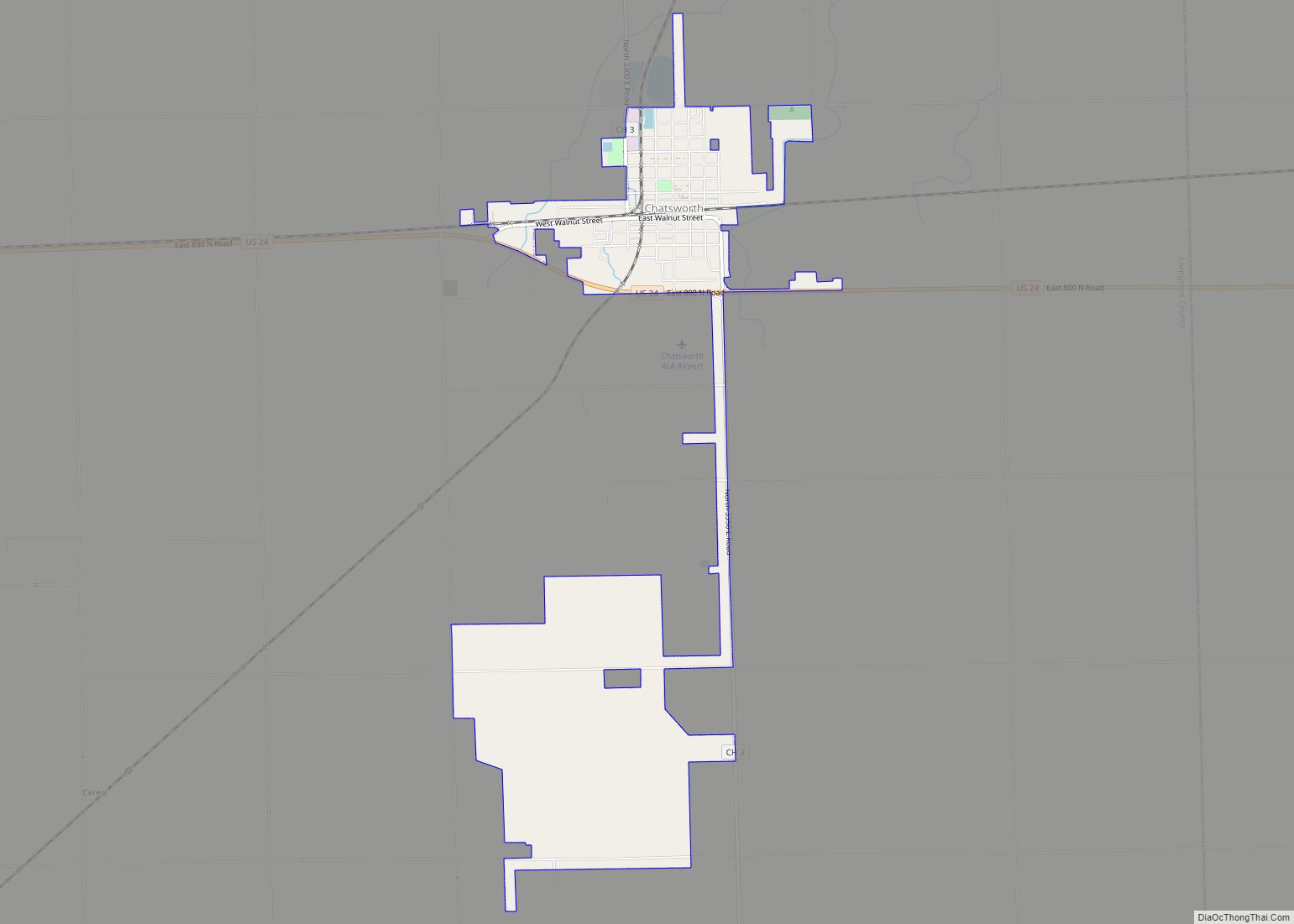
Chatsworth is an incorporated town in Livingston County, Illinois, United States. The population was 1,332 at the 2020 census. Chatsworth town overview: Name: Chatsworth town LSAD Code: 43 LSAD Description: town (suffix) State: Illinois County: Livingston County Incorporated: March 8, 1867 (1867-03-08) Elevation: 736 ft (224 m) Total Area: 2.69 sq mi (6.96 km²) Land Area: 2.68 sq mi (6.95 km²) Water Area: 0.01 sq mi (0.02 km²) Total … Read more

Map of Chenoa city

Map of Chenoa city

Chenoa is a city in McLean County, Illinois, United States. The population was 1,695 at the 2020 census. The city is located at the intersections of Interstate 55, Historic Route 66, and U.S. Route 24. Founded in 1854 by Mathew T. Scott, Chenoa was created to provide a retail and trade center for his farm … Read more

Map of Chemung CDP

Map of Chemung CDP

Chemung, elevation 896 feet (273 meters), is an unincorporated census-designated place in McHenry County, Illinois, United States. Per the 2020 census, the population was 276. Chemung CDP overview: Name: Chemung CDP LSAD Code: 57 LSAD Description: CDP (suffix) State: Illinois County: McHenry County Elevation: 896 ft (273 m) Total Area: 0.28 sq mi (0.73 km²) Land Area: 0.28 sq mi (0.73 km²) Water … Read more

Map of Cherry village

Map of Cherry village

Cherry is a village in Bureau County, Illinois, United States. The population was 435 at the 2020 census. It is part of the Ottawa Micropolitan Statistical Area. It is located northwest of LaSalle–Peru, just a few miles north of Interstate 80, and is about 75 miles (121 km) east of the Quad Cities. Cherry was the … Read more

Map of Cherry Valley village, Illinois

Map of Cherry Valley village, Illinois

Cherry Valley is a village of 8.72 square miles (22.6 km) that lies primarily in Winnebago County. Approximately ten percent of the village is within Boone County. The village is within the Rockford, Illinois Metropolitan Statistical Area, and borders the southeast side of Rockford. It is also within the Kishwaukee River valley. The population is 2905 … Read more

Map of Chesterfield village

Map of Chesterfield village, Illinois

Chesterfield is a village in Macoupin County, Illinois, United States. The population was 170 at the 2020 census. Chesterfield village overview: Name: Chesterfield village LSAD Code: 47 LSAD Description: village (suffix) State: Illinois County: Macoupin County Elevation: 595 ft (181 m) Total Area: 0.54 sq mi (1.40 km²) Land Area: 0.54 sq mi (1.40 km²) Water Area: 0.00 sq mi (0.00 km²) Total Population: 170 Population … Read more

Map of Chester city, Illinois

Map of Chester city, Illinois

Chester is a city in and the county seat of Randolph County, Illinois, United States, on a bluff above the Mississippi River. The population was 6,814 at the 2020 census. It lies 61 miles (98 km) south of St. Louis, Missouri. Chester city overview: Name: Chester city LSAD Code: 25 LSAD Description: city (suffix) State: Illinois … Read more

Map of Chicago Heights city

Map of Chicago Heights city

Chicago Heights city overview: Name: Chicago Heights city LSAD Code: 25 LSAD Description: city (suffix) State: Illinois County: Cook County Incorporated: 1893 Total Area: 10.30 sq mi (26.67 km²) Land Area: 10.28 sq mi (26.63 km²) Water Area: 0.01 sq mi (0.03 km²)  0.10% Total Population: 27,480 Population Density: 2,672.37/sq mi (1,031.85/km²) Area code: 708 FIPS code: 1714026 Website: cityofchicagoheights.org Online Interactive Map Chicago Heights … Read more

Map of Chestnut CDP

Map of Chestnut CDP

Chestnut is a census-designated place in Aetna Township, Logan County, Illinois. As of the 2010 census, its population was 246. The community is located northwest across the railroad tracks along Illinois Route 54 at Dauphin Street. Its claim to fame, for the sake of town promotion, is that it is the geographic center of the … Read more

Map of Chillicothe city, Illinois

Map of Chillicothe city, Illinois

Chillicothe is a city on the Illinois River in Peoria County, Illinois, United States. The population was 6,097 at the 2010 census. Chillicothe is just north of the city of Peoria and is part of the Peoria Metropolitan Statistical Area. Chillicothe city overview: Name: Chillicothe city LSAD Code: 25 LSAD Description: city (suffix) State: Illinois … Read more

Map of Chicago Ridge village

Map of Chicago Ridge village

Chicago Ridge is a village in Cook County, Illinois, United States. Per the 2020 census, the population was 14,433. Chicago Ridge village overview: Name: Chicago Ridge village LSAD Code: 47 LSAD Description: village (suffix) State: Illinois County: Cook County Incorporated: 1914 Total Area: 2.27 sq mi (5.87 km²) Land Area: 2.27 sq mi (5.87 km²) Water Area: 0.00 sq mi (0.00 km²)  0% Total … Read more

Map of Christopher city

Map of Christopher city

Christopher is a city in Franklin County, Illinois, United States. The population was 2,382 at the time of the 2010 census. Christopher city overview: Name: Christopher city LSAD Code: 25 LSAD Description: city (suffix) State: Illinois County: Franklin County Elevation: 440 ft (130 m) Total Area: 1.64 sq mi (4.24 km²) Land Area: 1.62 sq mi (4.20 km²) Water Area: 0.01 sq mi (0.04 km²) Total … Read more