Map of Jerseyville city

Map of Jerseyville city

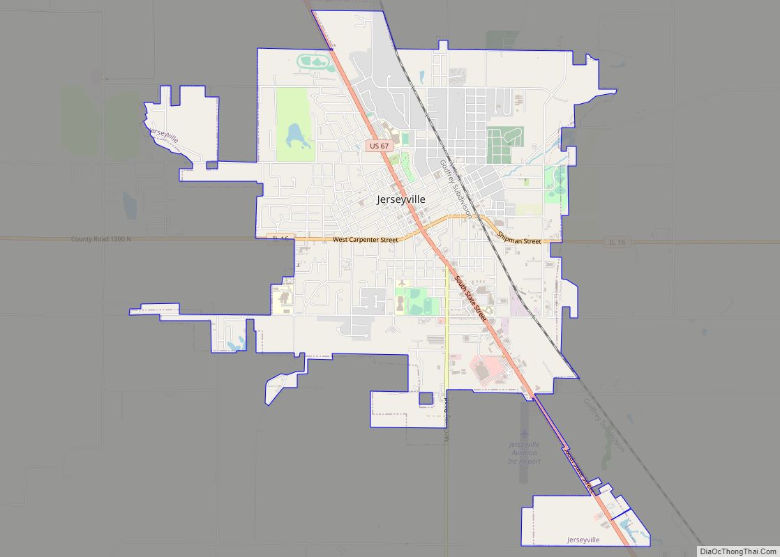
Jerseyville is the largest city in and the county seat of Jersey County, Illinois, United States. At the 2020 census, the city had a total population of 8,337. Jerseyville is a part of Southern Illinois, the Metro-East region and the St. Louis Metropolitan Statistical Area. Jerseyville city overview: Name: Jerseyville city LSAD Code: 25 LSAD … Read more

Map of Johnsonville village

Map of Johnsonville village, Illinois

Johnsonville is a village in Wayne County, Illinois, United States. The population was 69 at the 2000 census. Johnsonville village overview: Name: Johnsonville village LSAD Code: 47 LSAD Description: village (suffix) State: Illinois County: Wayne County Elevation: 548 ft (167 m) Total Area: 0.21 sq mi (0.55 km²) Land Area: 0.21 sq mi (0.55 km²) Water Area: 0.00 sq mi (0.00 km²) Total Population: 72 Population … Read more

Map of Johnsburg village

Map of Johnsburg village

Johnsburg is a village in McHenry County, Illinois. It is a northwestern suburb of Chicago with a population of 6,355 as of the 2020 U.S. census. Johnsburg village overview: Name: Johnsburg village LSAD Code: 47 LSAD Description: village (suffix) State: Illinois County: McHenry County Total Area: 7.84 sq mi (20.32 km²) Land Area: 7.25 sq mi (18.78 km²) Water Area: 0.60 sq mi … Read more

Map of Jonesboro city, Illinois

Map of Jonesboro city, Illinois

Jonesboro is a city in Union County, Illinois, United States. The population was 1,821 at the 2010 census, a decline from 1,853 in 2000. It is the county seat of Union County. The city is known for being tied to its close neighbor Anna, together known as Anna-Jonesboro. Jonesboro city overview: Name: Jonesboro city LSAD … Read more

Map of Johnston City city

Map of Johnston City

Johnston City is a city in Williamson County, Illinois, United States. The population was 3,348 at the 2020 census. This was a center of coal mining in the early 20th century, having a peak of population in the 1920s. The mining jobs attracted many immigrants from Europe. Johnston City city overview: Name: Johnston City city … Read more

Map of Joy village

Map of Joy village

Joy is a village in Mercer County, Illinois, United States. The population was 372 as of the 2020 census. The origin of the name: “Joy” was named when founded in 1869 after the president of the Chicago, Burlington and Quincy Railroad, J. F. Joy. Joy village overview: Name: Joy village LSAD Code: 47 LSAD Description: … Read more

Map of Joppa village, Illinois

Map of Joppa village, Illinois

Joppa is a village in Massac County, Illinois, United States, along the Ohio River. The population was 350 as of the 2020 census. It is part of the Paducah, KY-IL Micropolitan Statistical Area. Joppa village overview: Name: Joppa village LSAD Code: 47 LSAD Description: village (suffix) State: Illinois County: Massac County Elevation: 355 ft (108 m) Total … Read more

Map of Junction village

Map of Junction village, Illinois

Junction is a village in Gallatin County, Illinois, United States. The population was 56 at the 2020 census. Junction village overview: Name: Junction village LSAD Code: 47 LSAD Description: village (suffix) State: Illinois County: Gallatin County Elevation: 367 ft (112 m) Total Area: 0.83 sq mi (2.14 km²) Land Area: 0.83 sq mi (2.14 km²) Water Area: 0.00 sq mi (0.00 km²) Total Population: 56 Population … Read more

Map of Junction City village, Illinois

Map of Junction City village, Illinois

Junction City is a village in Marion County, Illinois, United States. The population was 527 at the 2020 census. Junction City village overview: Name: Junction City village LSAD Code: 47 LSAD Description: village (suffix) State: Illinois County: Marion County Elevation: 492 ft (150 m) Total Area: 0.70 sq mi (1.82 km²) Land Area: 0.68 sq mi (1.77 km²) Water Area: 0.02 sq mi (0.05 km²) Total … Read more

Map of Kampsville village

Map of Kampsville village

Kampsville is a village in Calhoun County, Illinois, United States, located on the west bank of the Illinois River. The population was 310 at the 2022 census. Kampsville village overview: Name: Kampsville village LSAD Code: 47 LSAD Description: village (suffix) State: Illinois County: Calhoun County Elevation: 446 ft (136 m) Total Area: 1.24 sq mi (3.21 km²) Land Area: 1.02 sq mi … Read more

Map of Justice village

Map of Justice village, Illinois

Justice is a village in Cook County, Illinois, United States, established in 1911. Per the 2020 census, the population was 12,600. Justice village overview: Name: Justice village LSAD Code: 47 LSAD Description: village (suffix) State: Illinois County: Cook County Total Area: 2.88 sq mi (7.47 km²) Land Area: 2.84 sq mi (7.35 km²) Water Area: 0.04 sq mi (0.12 km²) Total Population: 12,600 Population … Read more

Map of Kaneville village

Map of Kaneville village

Kaneville is a village in southwestern Kane County, Illinois, United States. It was incorporated in November 2006, and the first elected officials were chosen in elections held on April 17, 2007. The village had a population of 484 at the 2010 census. Kaneville is part of the Chicago metropolitan area. The village was originally called … Read more