Map of Long Creek village

Map of Long Creek village, Illinois

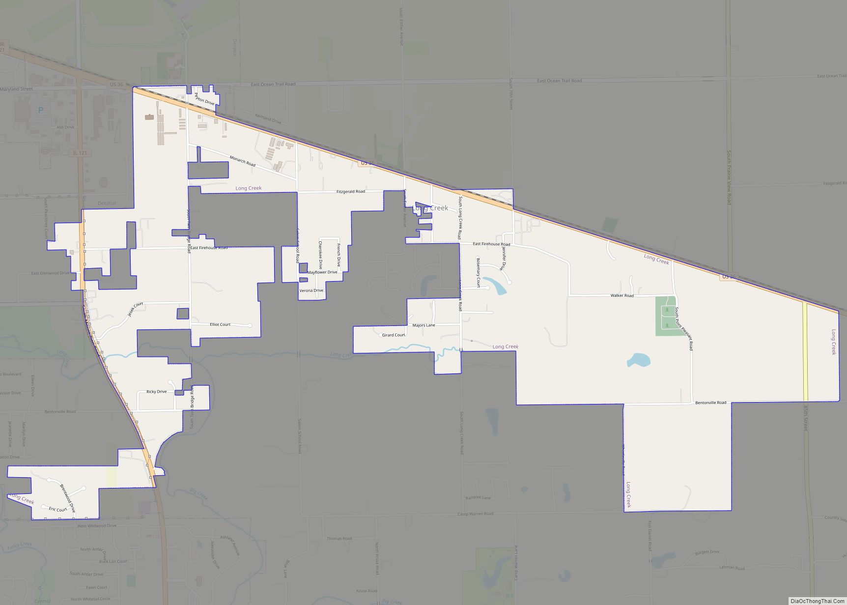
Long Creek is a village in Macon County, Illinois, United States. As of the 2020 census its 1,261. It is included in the Decatur, Illinois Metropolitan Statistical Area. Long Creek village overview: Name: Long Creek village LSAD Code: 47 LSAD Description: village (suffix) State: Illinois County: Macon County Elevation: 672 ft (205 m) Total Area: 2.83 sq mi (7.32 km²) … Read more

Map of Long Point village

Map of Long Point village

Long Point is a village in Livingston County, Illinois, United States. The population was 226 at the 2010 census. Long Point village overview: Name: Long Point village LSAD Code: 47 LSAD Description: village (suffix) State: Illinois County: Livingston County Elevation: 636 ft (194 m) Total Area: 0.18 sq mi (0.48 km²) Land Area: 0.18 sq mi (0.48 km²) Water Area: 0.00 sq mi (0.00 km²) Total … Read more

Map of Long Lake CDP

Map of Long Lake CDP, Illinois

Long Lake is an unincorporated community and census-designated place (CDP) in Lake County, Illinois, United States. Per the 2020 census, the population was 3,663. Long Lake CDP overview: Name: Long Lake CDP LSAD Code: 57 LSAD Description: CDP (suffix) State: Illinois County: Lake County Total Area: 1.78 sq mi (4.61 km²) Land Area: 1.18 sq mi (3.06 km²) Water Area: 0.60 sq mi … Read more

Map of Loraine village

Map of Loraine village, Illinois

Loraine is a village in Adams County, Illinois, United States. The population was 300 at the 2020 census. Loraine village overview: Name: Loraine village LSAD Code: 47 LSAD Description: village (suffix) State: Illinois County: Adams County Elevation: 640 ft (200 m) Total Area: 0.84 sq mi (2.19 km²) Land Area: 0.84 sq mi (2.19 km²) Water Area: 0.00 sq mi (0.00 km²)  0% Total Population: 300 … Read more

Map of Longview village

Map of Longview village, Illinois

Longview is a village in Champaign County, Illinois, United States. The population was 112 at the 2020 census. Longview village overview: Name: Longview village LSAD Code: 47 LSAD Description: village (suffix) State: Illinois County: Champaign County Elevation: 680 ft (210 m) Total Area: 0.25 sq mi (0.64 km²) Land Area: 0.25 sq mi (0.64 km²) Water Area: 0.00 sq mi (0.00 km²) Total Population: 112 Population … Read more

Map of Lostant village

Map of Lostant village

Lostant is a village in LaSalle County, Illinois, United States. The population was 423 at the 2020 census, down from 498 at the 2010 census. It is part of the Ottawa Micropolitan Statistical Area. Lostant village overview: Name: Lostant village LSAD Code: 47 LSAD Description: village (suffix) State: Illinois County: LaSalle County Elevation: 692 ft (211 m) … Read more

Map of Lost Nation CDP, Illinois

Map of Lost Nation CDP, Illinois

Lost Nation, Illinois is an unincorporated census-designated place in Ogle County, Illinois, United States, located south of the city of Oregon. As of the 2010 census, its population was 708. Lost Nation has an area of 2.552 square miles (6.61 km); 2.441 square miles (6.32 km) of this is land, and 0.111 square miles (0.29 km) is water. … Read more

Map of Loves Park city

Map of Loves Park city

Loves Park is a city in Boone and Winnebago counties in the U.S. state of Illinois. Most of the city is in Winnebago County, with a tiny sliver in the east located in Boone County. The population was 23,996 at the 2010 census, up from 20,044 in 2000. Loves Park is part of the Rockford … Read more

Map of Louisville village, Illinois

Map of Louisville village, Illinois

Louisville is a village in Clay County, Illinois, United States, along the Little Wabash River. The population was 1,136 at the 2020 census. It is the county seat of Clay County. The proper pronunciation of “Louisville” in the local dialect of mid-southern American is “Loose-vil” and is phonetically distinct from the southern American pronunciation of … Read more

Map of Ludlow village

Map of Ludlow village, Illinois

Ludlow is a village in Champaign County, Illinois, United States. The population was 308 at the 2020 census. Ludlow village overview: Name: Ludlow village LSAD Code: 47 LSAD Description: village (suffix) State: Illinois County: Champaign County Elevation: 774 ft (236 m) Total Area: 0.40 sq mi (1.03 km²) Land Area: 0.40 sq mi (1.03 km²) Water Area: 0.00 sq mi (0.00 km²) Total Population: 308 Population … Read more

Map of Lovington village

Map of Lovington village, Illinois

Lovington is a village in Moultrie County, Illinois, United States. The population was 1,069 at the 2020 census. Lovington was named after Andrew Love, the first postmaster in the area. Lovington village overview: Name: Lovington village LSAD Code: 47 LSAD Description: village (suffix) State: Illinois County: Moultrie County Elevation: 682 ft (208 m) Total Area: 0.54 sq mi (1.41 km²) … Read more

Map of Lynnville village, Illinois

Map of Lynnville village, Illinois

Lynnville is a village in Morgan County, Illinois, United States. The population was 96 at the 2020 census. It is part of the Jacksonville Micropolitan Statistical Area. Lynnville village overview: Name: Lynnville village LSAD Code: 47 LSAD Description: village (suffix) State: Illinois County: Morgan County Elevation: 620 ft (190 m) Total Area: 0.08 sq mi (0.20 km²) Land Area: 0.08 sq mi … Read more