Map of Mitchell CDP, Illinois

Map of Mitchell CDP, Illinois

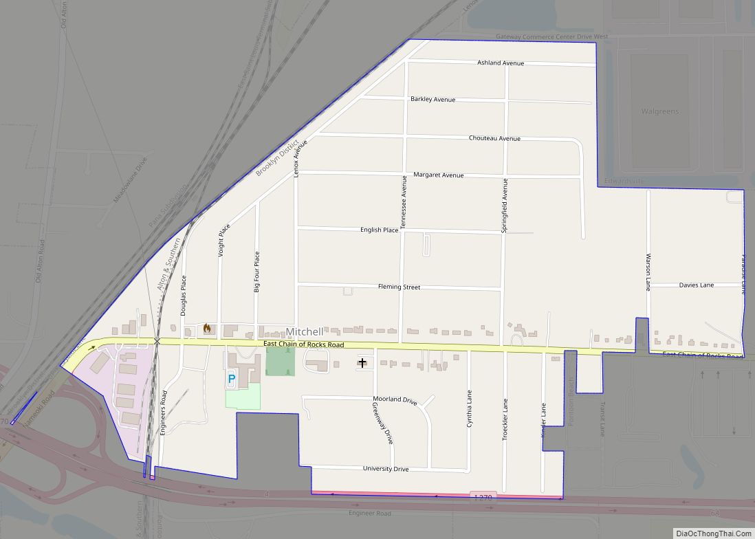
Mitchell is an unincorporated community and census-designated place (CDP) in Madison County, Illinois, United States. As of the 2020 census, its population was 1,217. It is part of the Metro East region of greater St. Louis. Mitchell CDP overview: Name: Mitchell CDP LSAD Code: 57 LSAD Description: CDP (suffix) State: Illinois County: Madison County Elevation: … Read more

Map of Moline city

Map of Moline city, Illinois

Moline (/moʊˈliːn/ moh-LEEN) is a city located in Rock Island County, Illinois, United States. With a population of 42,985 in 2020, it is the largest city in Rock Island County. Moline is one of the Quad Cities, along with neighboring East Moline and Rock Island in Illinois and the cities of Davenport and Bettendorf in … Read more

Map of Mokena village

Map of Mokena village

Mokena (/moʊˈkinə/moh-KEE-nuh) is a village in Will County, Illinois, United States. It is a south suburb of Chicago. The population was 19,887 at the 2020 census. The Census Bureau’s 2019 estimate found that the population had increased to 20,159. Mokena village overview: Name: Mokena village LSAD Code: 47 LSAD Description: village (suffix) State: Illinois County: … Read more

Map of Monee village

Map of Monee village

Monee is a village in Will County, Illinois, United States, a south suburb of Chicago. The population was 5,128 at the 2020 census. Monee village overview: Name: Monee village LSAD Code: 47 LSAD Description: village (suffix) State: Illinois County: Will County Total Area: 4.47 sq mi (11.59 km²) Land Area: 4.47 sq mi (11.59 km²) Water Area: 0.00 sq mi (0.00 km²) Total Population: … Read more

Map of Momence city

Map of Momence city

Momence is a city and capital of Momence Township, Kankakee County, Illinois, United States. The population was 3,171 at the 2000 census, and 3,310 in 2010. It is part of the Kankakee–Bradley Metropolitan Statistical Area. Momence city overview: Name: Momence city LSAD Code: 25 LSAD Description: city (suffix) State: Illinois County: Kankakee County Elevation: 620 ft … Read more

Map of Monroe Center village

Map of Monroe Center village

Monroe Center is a village in Ogle County, Illinois, United States, southeast of Rockford in Monroe Township. It is located on the Canadian Pacific Railway and on Illinois Route 72, about .6 mile east of Exit 111 from Interstate 39. The village had a population of 471 at the 2010 census. The controversial Great Lakes … Read more

Map of Monmouth city, Illinois

Map of Monmouth city, Illinois

Monmouth is a city in and the county seat of Warren County, Illinois, United States. The population was 8,902 at the 2020 census, down from 9,444 in 2010. It is the home of Monmouth College and contains Monmouth Park, Harmon Park, North Park, Warfield Park, West Park, South Park, Garwood Park, Buster White Park and … Read more

Map of Monticello city, Illinois

Map of Monticello city, Illinois

Monticello (/ˌmɒntɪˈsɛloʊ/ (listen) MON-tiss-EL-oh) is a city and county seat of Piatt County, Illinois, United States. The population was 5,941 at the 2020 census. Monticello city overview: Name: Monticello city LSAD Code: 25 LSAD Description: city (suffix) State: Illinois County: Piatt County Elevation: 656 ft (200 m) Total Area: 3.89 sq mi (10.08 km²) Land Area: 3.85 sq mi (9.98 km²) Water Area: … Read more

Map of Montgomery village, Illinois

Map of Montgomery village, Illinois

Montgomery is a village within the Chicago Metropolitan Area of Kane and Kendall counties, Illinois. The village is a suburb of Chicago located roughly 45 miles (72 km) southwest of the city. The population was 20,262 at the 2020 census. Between 2000 and 2010 the village population grew 237 percent, making Montgomery the ninth fastest growing … Read more

Map of Morris city, Illinois

Map of Morris city, Illinois

Morris is a city in and the county seat of Grundy County, Illinois, United States and part of the southwest Chicago metropolitan area. The population was estimated at 15,053 in 2019. Morris city overview: Name: Morris city LSAD Code: 25 LSAD Description: city (suffix) State: Illinois County: Grundy County Founded: 1842 Elevation: 515 ft (157 m) Total … Read more

Map of Montrose village, Illinois

Map of Montrose village, Illinois

Montrose is a village in Effingham and Cumberland counties in the U.S. state of Illinois. The population was 210 at the 2020 census. The Effingham County portion of Montrose is part of the Effingham Micropolitan Statistical Area, while the small section that lies in Cumberland County is part of the Charleston–Mattoon Micropolitan Statistical Area. Montrose … Read more

Map of Morrisonville village

Map of Morrisonville village, Illinois

Morrisonville is a small town in Christian County, Illinois, United States. The population was 997 at the 2020 census. Morrisonville village overview: Name: Morrisonville village LSAD Code: 47 LSAD Description: village (suffix) State: Illinois County: Christian County Founded: 1869 Incorporated: May, 1872 Elevation: 620 ft (190 m) Total Area: 1.03 sq mi (2.68 km²) Land Area: 1.03 sq mi (2.68 km²) Water Area: … Read more