Map of Mundelein village

Map of Mundelein village

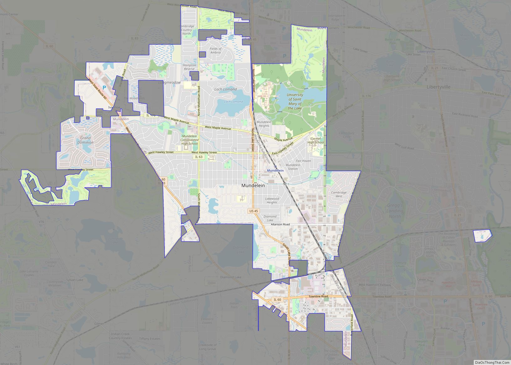
Mundelein is a village in Lake County, Illinois, United States and a northern suburb of Chicago. Per the 2020 census, the population was 31,560. It is approximately thirty-five miles northwest of Chicago. Mundelein village overview: Name: Mundelein village LSAD Code: 47 LSAD Description: village (suffix) State: Illinois County: Lake County Incorporated: 1909; 114 years ago (1909) Total … Read more

Map of Naplate village

Map of Naplate village

Naplate is a village in LaSalle County, Illinois, United States. The population was 412 at the 2020 census. It is part of the Ottawa Micropolitan Statistical Area. Naplate village overview: Name: Naplate village LSAD Code: 47 LSAD Description: village (suffix) State: Illinois County: LaSalle County Elevation: 482 ft (147 m) Total Area: 0.16 sq mi (0.41 km²) Land Area: 0.16 sq mi … Read more

Map of Murrayville village

Map of Murrayville village

Murrayville is a village in Morgan County, Illinois, United States. The population was 567 at the 2020 census. It is part of the Jacksonville Micropolitan Statistical Area. Murrayville village overview: Name: Murrayville village LSAD Code: 47 LSAD Description: village (suffix) State: Illinois County: Morgan County Elevation: 682 ft (208 m) Total Area: 0.50 sq mi (1.29 km²) Land Area: 0.50 sq mi … Read more

Map of Nashville city, Illinois

Map of Nashville city, Illinois

Nashville is a city in Washington County, Illinois, United States. As of the 2020 census, the city population was 3,105. It is the county seat of Washington County. Nashville city overview: Name: Nashville city LSAD Code: 25 LSAD Description: city (suffix) State: Illinois County: Washington County Founded: June 8, 1830 Elevation: 472 ft (144 m) Total Area: … Read more

Map of Naples town, Illinois

Map of Naples town, Illinois

Naples is an incorporated town in Scott County in the U.S. state of Illinois. The population was 100 at the 2020 census. It is part of the Jacksonville Micropolitan Statistical Area. Naples town overview: Name: Naples town LSAD Code: 43 LSAD Description: town (suffix) State: Illinois County: Scott County Incorporated: February 1, 1839 (1839-02-01) Elevation: 436 ft (133 m) Total … Read more

Map of Nauvoo city, Illinois

Map of Nauvoo city, Illinois

Nauvoo (/ˈnɔːvuː/ NAW-voo; from the Hebrew: נָאווּ‎, Modern: Navu, Tiberian: Nâwû, ‘they are beautiful’) is a small city in Hancock County, Illinois, United States, on the Mississippi River near Fort Madison, Iowa. The population of Nauvoo was 950 at the 2020 census. Nauvoo attracts visitors for its historic importance and its religious significance to members of several … Read more

Map of Nason city

Map of Nason city

Nason is a city in Jefferson County, Illinois, United States. The population was 236 people as of the 2010 census, making it the least populous incorporated city in the state of Illinois. It is part of the Mount Vernon Micropolitan Statistical Area. Nason city overview: Name: Nason city LSAD Code: 25 LSAD Description: city (suffix) … Read more

Map of Nelson village, Illinois

Map of Nelson village, Illinois

Nelson is a village in Lee County, Illinois, United States. The population was 170 at the 2010 census, up from 163 in 2000. Nelson village overview: Name: Nelson village LSAD Code: 47 LSAD Description: village (suffix) State: Illinois County: Lee County Total Area: 0.36 sq mi (0.94 km²) Land Area: 0.36 sq mi (0.92 km²) Water Area: 0.00 sq mi (0.01 km²) Total Population: … Read more

Map of Nebo village

Map of Nebo village, Illinois

Nebo is a village in southern Pike County, Illinois, United States. The population was 340 at the 2010 census, a decline from 408 in 2000. Nebo has three churches scattered throughout the city limits. Nebo village overview: Name: Nebo village LSAD Code: 47 LSAD Description: village (suffix) State: Illinois County: Pike County Elevation: 482 ft (147 m) … Read more

Map of Neponset village

Map of Neponset village

Neponset is a village in Bureau County, Illinois, United States. The population was 427 at the 2020 census. It is part of the Ottawa Micropolitan Statistical Area. Neponset village overview: Name: Neponset village LSAD Code: 47 LSAD Description: village (suffix) State: Illinois County: Bureau County Total Area: 1.016 sq mi (2.63 km²) Land Area: 1.016 sq mi (2.63 km²) Water Area: … Read more

Map of Neoga city

Map of Neoga city

Neoga is a city in Cumberland County, Illinois, United States. The population was 1,398 at the 2020 census, down from 1,636 at the 2010 census. It is part of the Charleston–Mattoon Micropolitan Statistical Area. The current mayor of Neoga is Marty Hartke. Neoga was incorporated in 1856. Neoga means “deer” in the Kickapoo language. Neoga … Read more

Map of New Baden village

Map of New Baden village

New Baden is a village in Clinton County, Illinois, United States (and partially in St. Clair County). The population was 3,428 at the 2020 census. New Baden village overview: Name: New Baden village LSAD Code: 47 LSAD Description: village (suffix) State: Illinois County: Clinton County, St. Clair County Elevation: 466 ft (142 m) Total Area: 1.82 sq mi (4.73 km²) … Read more