Mundelein is a village in Lake County, Illinois, United States and a northern suburb of Chicago. Per the 2020 census, the population was 31,560. It is approximately thirty-five miles northwest of Chicago.
| Name: | Mundelein village |
|---|---|
| LSAD Code: | 47 |
| LSAD Description: | village (suffix) |
| State: | Illinois |
| County: | Lake County |
| Incorporated: | 1909; 114 years ago (1909) |
| Total Area: | 9.99 sq mi (25.88 km²) |
| Land Area: | 9.59 sq mi (24.83 km²) |
| Water Area: | 0.41 sq mi (1.05 km²) 4.02% |
| Total Population: | 31,560 |
| Population Density: | 3,291.96/sq mi (1,271.09/km²) |
| Area code: | 847 and 224 |
| FIPS code: | 1751349 |
Online Interactive Map
Click on ![]() to view map in "full screen" mode.
to view map in "full screen" mode.
Mundelein location map. Where is Mundelein village?


History
The community now known as Mundelein has been inhabited since at least 1650, when the Potawatomi people were known to have been trading with French fur traders. The first European inhabitants reached the area in the early 19th century. Peter Shaddle (for whom a street is named) was the first known settler, building a log cabin in the area now owned by St. Mary of the Lake Seminary in 1835.
The next settlers were tradesmen escaping from England’s industrial depression, who became farmers in the Mundelein area. In honor of their former professions, they named the city “Mechanics Grove”, and built schools, churches, and businesses. The community grew and (while still unincorporated) changed its name to “Holcomb”, in honor of John Holcomb, a person who was active in the area’s development. As Holcomb, the community added a railway station and a post office. The Holcomb area incorporated in February 1909 under a new name, “Rockefeller”, a reference to businessman, John D. Rockefeller.
The name Rockefeller was short-lived, however. In July 1909, the community became “Area”. This name change was requested by a local educational entrepreneur named Arthur Sheldon, who bought 600 acres (2.4 km) near town and built a school on it. The school taught sales techniques, including the philosophy of “AREA”, which stood for “Ability, Reliability, Endurance, and Action.” At one time, it boasted 10,000 students, many of them women (which was unusual for 1909).
In 1915, Archbishop George Mundelein (later Cardinal) of Chicago purchased the property from Sheldon after the Area campus closed to re-establish the Archdiocese’s University of Saint Mary of the Lake, also known as the Mundelein Seminary, which continues to exist today.
On December 10, 1924, the Village Board held a special meeting with representatives from the Soo Line Railroad, who requested that the board change the village’s name to Mundelein (for the cardinal). The board voted to make the change and asked the Illinois Secretary of State to make the name change. They received permission in April 1925, and the Village Board passed an ordinance changing the village’s name to Mundelein. Cardinal Mundelein donated the village its first new fire truck, a 1925 Stoughton. The fire truck was officially turned over to the village at a ceremony held at the St. Mary of the Lake Seminary on July 17, 1925. The original Village Hall, built in 1929 with a few additions over the years, was used until June 2014.
In the 1970s the community was largely residential with a little light industrial development.
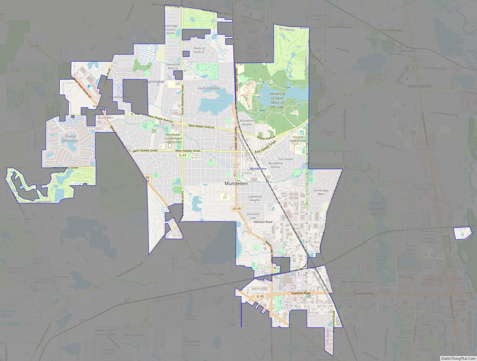
Mundelein Road Map
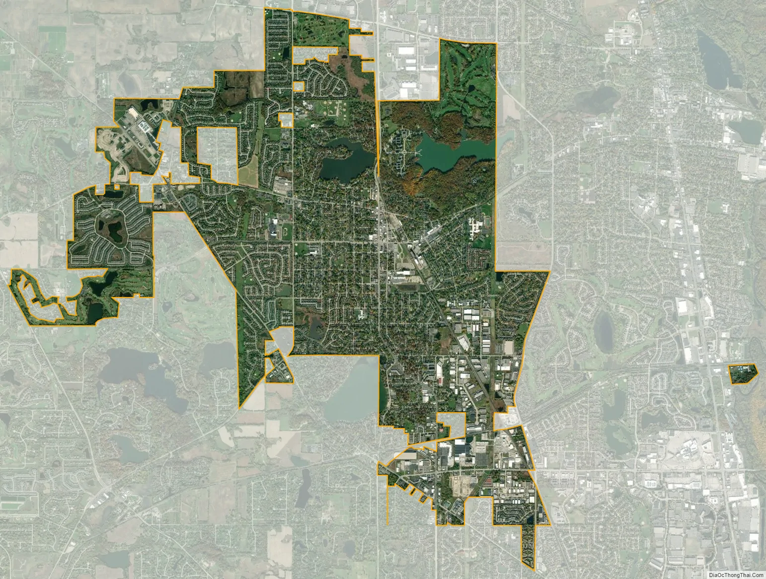
Mundelein city Satellite Map
Geography
Mundelein is located at 42°15’47.0″N 88°00’14.4″W (42.263049, -88.004010).
According to the 2010 census, Mundelein has a total area of 9.969 square miles (25.82 km), of which 9.57 square miles (24.79 km) (or 96%) is land and 0.399 square miles (1.03 km) (or 4%) is water.
See also
Map of Illinois State and its subdivision:- Adams
- Alexander
- Bond
- Boone
- Brown
- Bureau
- Calhoun
- Carroll
- Cass
- Champaign
- Christian
- Clark
- Clay
- Clinton
- Coles
- Cook
- Crawford
- Cumberland
- De Kalb
- De Witt
- Douglas
- Dupage
- Edgar
- Edwards
- Effingham
- Fayette
- Ford
- Franklin
- Fulton
- Gallatin
- Greene
- Grundy
- Hamilton
- Hancock
- Hardin
- Henderson
- Henry
- Iroquois
- Jackson
- Jasper
- Jefferson
- Jersey
- Jo Daviess
- Johnson
- Kane
- Kankakee
- Kendall
- Knox
- La Salle
- Lake
- Lake Michigan
- Lawrence
- Lee
- Livingston
- Logan
- Macon
- Macoupin
- Madison
- Marion
- Marshall
- Mason
- Massac
- McDonough
- McHenry
- McLean
- Menard
- Mercer
- Monroe
- Montgomery
- Morgan
- Moultrie
- Ogle
- Peoria
- Perry
- Piatt
- Pike
- Pope
- Pulaski
- Putnam
- Randolph
- Richland
- Rock Island
- Saint Clair
- Saline
- Sangamon
- Schuyler
- Scott
- Shelby
- Stark
- Stephenson
- Tazewell
- Union
- Vermilion
- Wabash
- Warren
- Washington
- Wayne
- White
- Whiteside
- Will
- Williamson
- Winnebago
- Woodford
- Alabama
- Alaska
- Arizona
- Arkansas
- California
- Colorado
- Connecticut
- Delaware
- District of Columbia
- Florida
- Georgia
- Hawaii
- Idaho
- Illinois
- Indiana
- Iowa
- Kansas
- Kentucky
- Louisiana
- Maine
- Maryland
- Massachusetts
- Michigan
- Minnesota
- Mississippi
- Missouri
- Montana
- Nebraska
- Nevada
- New Hampshire
- New Jersey
- New Mexico
- New York
- North Carolina
- North Dakota
- Ohio
- Oklahoma
- Oregon
- Pennsylvania
- Rhode Island
- South Carolina
- South Dakota
- Tennessee
- Texas
- Utah
- Vermont
- Virginia
- Washington
- West Virginia
- Wisconsin
- Wyoming


