Map of Otterville town

Map of Otterville town, Illinois

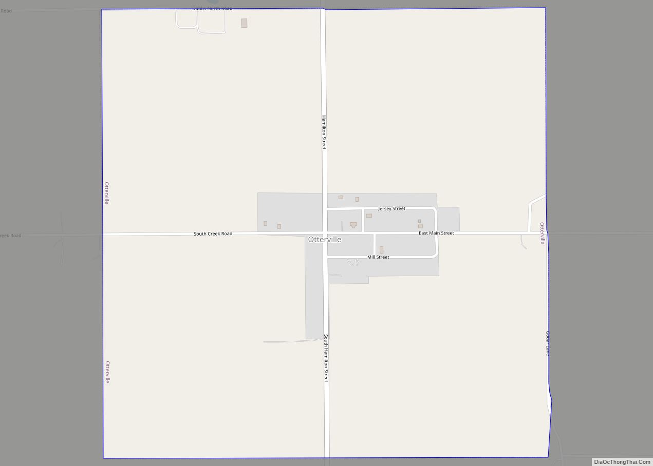
Otterville is an incorporated town in Jersey County, Illinois, United States. As of the 2020 census, the town had a total population of 87. Otterville town overview: Name: Otterville town LSAD Code: 43 LSAD Description: town (suffix) State: Illinois County: Jersey County Incorporated: March 7, 1867 (1867-03-07) Elevation: 627 ft (191 m) Total Area: 1.01 sq mi (2.61 km²) Land Area: 1.01 sq mi (2.61 km²) … Read more

Map of Palatine village

Map of Palatine village

Palatine (/ˈpælətaɪn/) is a village in Cook County, Illinois, United States. It is a northwestern residential suburb of Chicago. As of the 2020 census, it had a population of 67,908. As of the 2010 Census, it was the seventh-largest community in Cook County and the 18th-largest in Illinois. Palatine village overview: Name: Palatine village LSAD … Read more

Map of Paderborn CDP

Map of Paderborn CDP

Paderborn is a census-designated place in St. Clair County, Illinois, United States. Its population was 43 as of the 2010 census. Paderborn CDP overview: Name: Paderborn CDP LSAD Code: 57 LSAD Description: CDP (suffix) State: Illinois County: St. Clair County Elevation: 492 ft (150 m) Total Area: 0.15 sq mi (0.40 km²) Land Area: 0.15 sq mi (0.39 km²) Water Area: 0.00 sq mi (0.01 km²) … Read more

Map of Palmer village, Illinois

Map of Palmer village, Illinois

Palmer is a village in Christian County, Illinois, United States. The population was 216 at the 2010 census. Palmer village overview: Name: Palmer village LSAD Code: 47 LSAD Description: village (suffix) State: Illinois County: Christian County Elevation: 617 ft (188 m) Total Area: 0.99 sq mi (2.58 km²) Land Area: 0.99 sq mi (2.58 km²) Water Area: 0.00 sq mi (0.00 km²) Total Population: 216 Population … Read more

Map of Palestine village, Illinois

Map of Palestine village, Illinois

Palestine is a village in Crawford County, Illinois, United States. The population was 1,233 at the 2020 Census. Palestine village overview: Name: Palestine village LSAD Code: 47 LSAD Description: village (suffix) State: Illinois County: Crawford County Incorporated: February 15, 1855 Elevation: 449 ft (137 m) Total Area: 0.79 sq mi (2.04 km²) Land Area: 0.79 sq mi (2.04 km²) Water Area: 0.00 sq mi (0.00 km²) … Read more

Map of Palos Heights city

Map of Palos Heights city

Palos Heights is a city in Cook County, Illinois, United States. It is a southwest suburb of Chicago. Per the 2020 census, the population was 12,068. Palos Heights city overview: Name: Palos Heights city LSAD Code: 25 LSAD Description: city (suffix) State: Illinois County: Cook County Incorporated: 1959 Total Area: 3.87 sq mi (10.03 km²) Land Area: 3.77 sq mi … Read more

Map of Palmyra village

Map of Palmyra village, Illinois

Palmyra is a village in Macoupin County, Illinois, United States. The population was 605 at the 2020 census, down from 698 in 2010. Palmyra village overview: Name: Palmyra village LSAD Code: 47 LSAD Description: village (suffix) State: Illinois County: Macoupin County Elevation: 671 ft (205 m) Total Area: 1.00 sq mi (2.59 km²) Land Area: 1.00 sq mi (2.59 km²) Water Area: 0.00 sq mi … Read more

Map of Palos Park village

Map of Palos Park village

Palos Park is a village in southwestern Cook County, Illinois, United States. Per the 2020 census, the population was 4,899. Palos Park village overview: Name: Palos Park village LSAD Code: 47 LSAD Description: village (suffix) State: Illinois County: Cook County Incorporated: 1914 Total Area: 6.57 sq mi (17.02 km²) Land Area: 6.45 sq mi (16.70 km²) Water Area: 0.12 sq mi (0.31 km²)  1.01% … Read more

Map of Palos Hills city

Map of Palos Hills city

Palos Hills is a city in Cook County, Illinois, United States. It is a southwest suburb of Chicago. The city was established in 1958 and had reached a population of 18,530 in the 2020 census. It is the home of Moraine Valley Community College as well as Amos Alonzo Stagg High School. Palos Hills city … Read more

Map of Panama village, Illinois

Map of Panama village, Illinois

Panama is a village in Montgomery and Bond counties, Illinois, United States. The population was 337 at the 2020 census. Panama village overview: Name: Panama village LSAD Code: 47 LSAD Description: village (suffix) State: Illinois County: Bond County, Montgomery County Elevation: 594 ft (181 m) Total Area: 0.37 sq mi (0.95 km²) Land Area: 0.36 sq mi (0.94 km²) Water Area: 0.00 sq mi (0.00 km²) … Read more

Map of Pana city

Map of Pana city

Pana /ˈpeɪnə/ is a small town in Christian County, Illinois, United States. A small portion is in Shelby County. The population was 5,199 at the 2020 census. Pana city overview: Name: Pana city LSAD Code: 25 LSAD Description: city (suffix) State: Illinois County: Christian County, Shelby County Elevation: 679 ft (207 m) Total Area: 4.16 sq mi (10.78 km²) Land … Read more

Map of Panola village, Illinois

Map of Panola village, Illinois

Panola is a village in Woodford County, Illinois, United States. The population was 45 at the 2010 census. It is part of the Peoria, Illinois Metropolitan Statistical Area. Panola is one of the smallest communities in Illinois today. It is located about 2 miles (3.2 km) north of El Paso, along Illinois Route 251 (next to … Read more