Map of Shabbona village

Map of Shabbona village

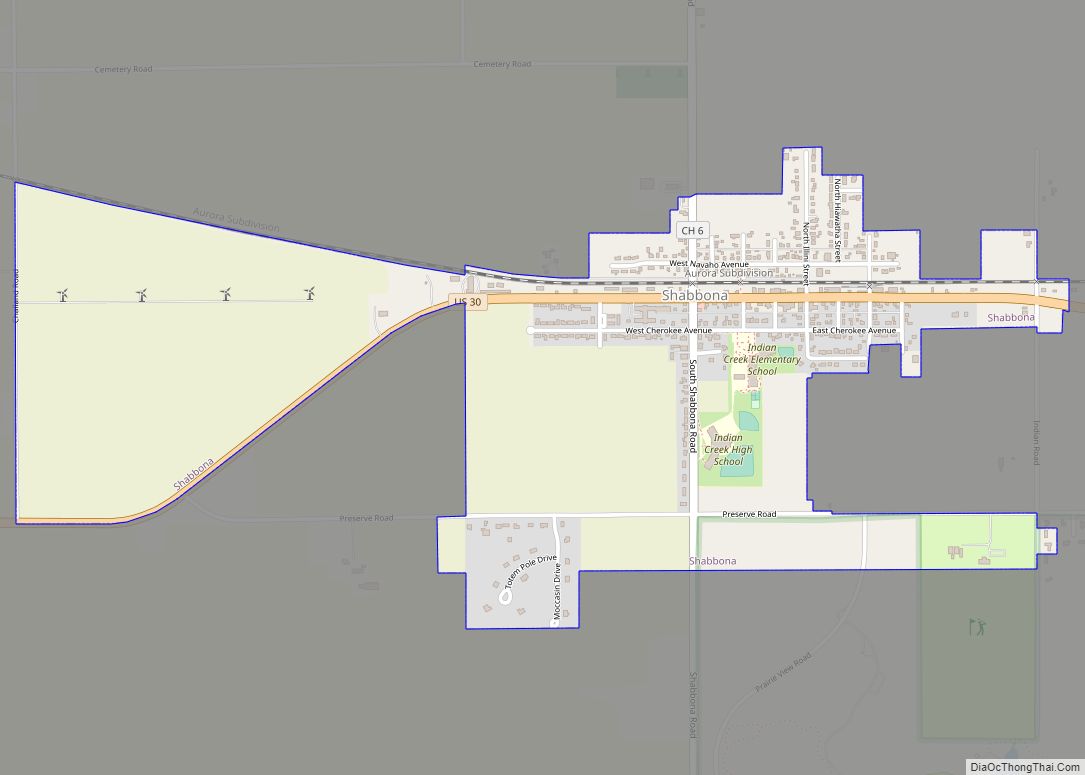
Shabbona (/ˈʃæˌbʌnə/) is a village in DeKalb County, Illinois, United States. The population was 863 at the 2020 census, down from 925 at the 2010 census. Shabbona village overview: Name: Shabbona village LSAD Code: 47 LSAD Description: village (suffix) State: Illinois County: DeKalb County Total Area: 1.28 sq mi (3.32 km²) Land Area: 1.28 sq mi (3.32 km²) Water Area: 0.00 sq mi … Read more

Map of Sheffield village, Illinois

Map of Sheffield village, Illinois

Sheffield is a village in Bureau County, Illinois, United States. The population was 821 at the 2020 census. It is part of the Ottawa Micropolitan Statistical Area. Sheffield was founded by Joseph E. Sheffield and Henry Farnam in 1852. Sheffield and Farnam constructed the Chicago and Rock Island Railroad, and the town site was intended … Read more

Map of Shawneetown city

Map of Shawneetown city

Shawneetown is a city in Gallatin County, Illinois, United States. The population was 1,239 at the 2010 census, down from 1,410 at the 2000 census. It is the county seat of Gallatin County. Shawneetown city overview: Name: Shawneetown city LSAD Code: 25 LSAD Description: city (suffix) State: Illinois County: Gallatin County Elevation: 407 ft (124 m) Total … Read more

Map of Sheldon village, Illinois

Map of Sheldon village, Illinois

Sheldon is a village in Sheldon Township, Iroquois County, Illinois, United States. The population was 1,070 at the 2010 census, down from 1,232 at the 2000 census. Sheldon village overview: Name: Sheldon village LSAD Code: 47 LSAD Description: village (suffix) State: Illinois County: Iroquois County Elevation: 682 ft (208 m) Total Area: 0.75 sq mi (1.95 km²) Land Area: 0.75 sq mi … Read more

Map of Shelbyville city

Map of Shelbyville city, Illinois

Shelbyville is a city in and the county seat of Shelby County, Illinois, United States, along the Kaskaskia River. As of the 2020 census, the population was at 4,674. HSHS Good Shepherd Hospital, located in town, is the county’s only hospital. Shelbyville is also home to Chautauqua Auditorium. Shelbyville city overview: Name: Shelbyville city LSAD … Read more

Map of Sherman village

Map of Sherman village, Illinois

Sherman is a village in Sangamon County, Illinois, United States. The population was 4,148 at the 2010 census. It is part of the Springfield, Illinois Metropolitan Statistical Area. Sherman village overview: Name: Sherman village LSAD Code: 47 LSAD Description: village (suffix) State: Illinois County: Sangamon County Elevation: 598 ft (182 m) Total Area: 3.19 sq mi (8.25 km²) Land Area: … Read more

Map of Sheridan village, Illinois

Map of Sheridan village, Illinois

Sheridan is a village in LaSalle County, Illinois, United States. As of the 2020 census, the village’s population was 2,431, up from 2,137 at the 2010 census. It is part of the Ottawa Micropolitan Statistical Area. Sheridan village overview: Name: Sheridan village LSAD Code: 47 LSAD Description: village (suffix) State: Illinois County: LaSalle County Elevation: … Read more

Map of Shiloh village, Illinois

Map of Shiloh village, Illinois

Shiloh is a village in St. Clair County, Illinois, United States. The 2010 census recorded a population of 12,651. Shiloh is located within the St. Louis metropolitan area Shiloh village overview: Name: Shiloh village LSAD Code: 47 LSAD Description: village (suffix) State: Illinois County: St. Clair County Elevation: 561 ft (171 m) Total Area: 11.13 sq mi (28.84 km²) Land … Read more

Map of Sherrard village

Map of Sherrard village

Sherrard is a village in Mercer County, Illinois, United States. The population was 692 at the 2020 census. Sherrard village overview: Name: Sherrard village LSAD Code: 47 LSAD Description: village (suffix) State: Illinois County: Mercer County Elevation: 805 ft (245 m) Total Area: 1.16 sq mi (3.00 km²) Land Area: 0.93 sq mi (2.40 km²) Water Area: 0.23 sq mi (0.60 km²) Total Population: 692 Population … Read more

Map of Shorewood village

Map of Shorewood village, Illinois

Shorewood is a village in Troy Township, Will County, Illinois, United States. The population was 7,686 at the 2000 census, and estimated to be 15,615 as of 2010. Shorewood village overview: Name: Shorewood village LSAD Code: 47 LSAD Description: village (suffix) State: Illinois County: Will County Incorporated: November 27, 1957 (1957-11-27) Elevation: 620 ft (190 m) Total Area: 8.20 sq mi (21.23 km²) … Read more

Map of Shipman town

Map of Shipman town, Illinois

Shipman is a village in Macoupin County, Illinois, United States. The population was 511 at the 2020 census, down from 624 in 2010. Shipman town overview: Name: Shipman town LSAD Code: 43 LSAD Description: town (suffix) State: Illinois County: Macoupin County Elevation: 630 ft (190 m) Total Area: 1.33 sq mi (3.45 km²) Land Area: 1.32 sq mi (3.42 km²) Water Area: 0.01 sq mi … Read more

Map of Sibley village, Illinois

Map of Sibley village, Illinois

Sibley is a village in Ford County, Illinois, United States. The population was 272 at the 2010 census. Sibley village overview: Name: Sibley village LSAD Code: 47 LSAD Description: village (suffix) State: Illinois County: Ford County Elevation: 805 ft (245 m) Total Area: 0.49 sq mi (1.28 km²) Land Area: 0.48 sq mi (1.24 km²) Water Area: 0.01 sq mi (0.03 km²) Total Population: 288 Population … Read more