Map of Smithton village

Map of Smithton village, Illinois

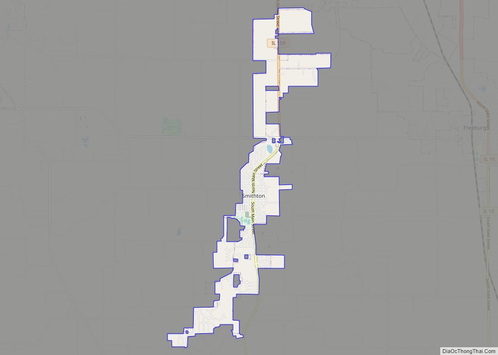
Smithton is a village in St. Clair County, Illinois, United States. The population was 4,006 in the 2020 United States Census. It is part of the Metro East region of Greater Saint Louis. Smithton village overview: Name: Smithton village LSAD Code: 47 LSAD Description: village (suffix) State: Illinois County: St. Clair County Elevation: 476 ft (145 m) … Read more

Map of South Barrington village

Map of South Barrington village

South Barrington is a residential suburb in Cook County, Illinois, United States, south of Barrington. Per the 2020 census, the population was 5,077. South Barrington is a wealthy suburb of Chicago. It is the location of the famous megachurch Willow Creek Community Church, Goebbert’s Pumpkin Patch and Farm, and a lifestyle center (shopping center) named … Read more

Map of Sorento village

Map of Sorento village

Sorento is a village in Bond County, Illinois, United States. The population was 429 at the 2020 census. Sorento is part of the St. Louis Metropolitan Statistical Area. It is also considered part of the Metro East region of Illinois. Sorento village overview: Name: Sorento village LSAD Code: 47 LSAD Description: village (suffix) State: Illinois … Read more

Map of South Chicago Heights village

Map of South Chicago Heights village

South Chicago Heights is a village and a south suburb in Cook County, Illinois, United States. The population was 4,026 at the 2020 census. South Chicago Heights village overview: Name: South Chicago Heights village LSAD Code: 47 LSAD Description: village (suffix) State: Illinois County: Cook County Total Area: 1.60 sq mi (4.14 km²) Land Area: 1.58 sq mi (4.09 km²) Water … Read more

Map of South Beloit city

Map of South Beloit city

South Beloit, is a city located in Winnebago County, Illinois, USA. It is part of the Rockford Metropolitan Area, but it is also a suburban extension of Beloit, Wisconsin. South Beloit, is directly along the border of smaller cities and towns north of Rockfords border. At the 2010 census, the city’s population was 7,892, up … Read more

Map of South Holland village

Map of South Holland village

South Holland is a village and south suburb of Chicago in Cook County, Illinois, United States, within Thornton Township. The population was 21,465 at the 2020 census. South Holland village overview: Name: South Holland village LSAD Code: 47 LSAD Description: village (suffix) State: Illinois County: Cook County Incorporated: May 12, 1894 Elevation: 601 ft (183 m) Total … Read more

Map of South Elgin village

Map of South Elgin village

South Elgin is a village in Kane County, Illinois, United States. Per the 2020 census, the population was 23,865. In 2007, Money magazine named South Elgin as 82nd of 100 entries in its “America’s Best Places to Live” edition and again in 2011 as 98th of 100 entries. South Elgin village overview: Name: South Elgin … Read more

Map of South Pekin village

Map of South Pekin village

South Pekin is a village in Tazewell County, Illinois, United States. The population was 996 at the 2020 census and is part of the Peoria, Illinois Metropolitan Statistical Area. South Pekin village overview: Name: South Pekin village LSAD Code: 47 LSAD Description: village (suffix) State: Illinois County: Tazewell County Founded: April 12, 1917 Elevation: 512 ft … Read more

Map of South Jacksonville village

Map of South Jacksonville village

South Jacksonville is a village in Morgan County, Illinois, United States. The population was 3,302 at the 2020 census. It is part of the Jacksonville Micropolitan Statistical Area. South Jacksonville village overview: Name: South Jacksonville village LSAD Code: 47 LSAD Description: village (suffix) State: Illinois County: Morgan County Elevation: 604 ft (184 m) Total Area: 2.33 sq mi (6.02 km²) … Read more

Map of South Wilmington village

Map of South Wilmington village

South Wilmington is a village in Grundy County, Illinois, United States. The population was 702 at the 2020 census. Although the name might indicate proximity to the city of Wilmington, South Wilmington is approximately 11 miles southwest of Wilmington, and is separated from it by several communities, including Gardner, Braceville, Godley, and Braidwood. South Wilmington … Read more

Map of South Roxana village

Map of South Roxana village

South Roxana, incorporated in March 1967, is a village in Madison County, Illinois, United States. The population was 1,891 at the 2020 census. South Roxana village overview: Name: South Roxana village LSAD Code: 47 LSAD Description: village (suffix) State: Illinois County: Madison County Elevation: 427 ft (130 m) Total Area: 2.26 sq mi (5.85 km²) Land Area: 2.16 sq mi (5.59 km²) Water … Read more

Map of Sparland village

Map of Sparland village

Sparland is a village in Marshall County, Illinois, United States. The population was 366 at the 2020 census, down from 406 in 2010. It is part of the Peoria Metropolitan Statistical Area. Sparland village overview: Name: Sparland village LSAD Code: 47 LSAD Description: village (suffix) State: Illinois County: Marshall County Elevation: 469 ft (143 m) Total Area: … Read more