South Roxana, incorporated in March 1967, is a village in Madison County, Illinois, United States. The population was 1,891 at the 2020 census.
| Name: | South Roxana village |
|---|---|
| LSAD Code: | 47 |
| LSAD Description: | village (suffix) |
| State: | Illinois |
| County: | Madison County |
| Elevation: | 427 ft (130 m) |
| Total Area: | 2.26 sq mi (5.85 km²) |
| Land Area: | 2.16 sq mi (5.59 km²) |
| Water Area: | 0.10 sq mi (0.26 km²) |
| Total Population: | 1,891 |
| ZIP code: | 62087 |
| Area code: | 618 |
| FIPS code: | 1771240 |
| GNISfeature ID: | 2399856 |
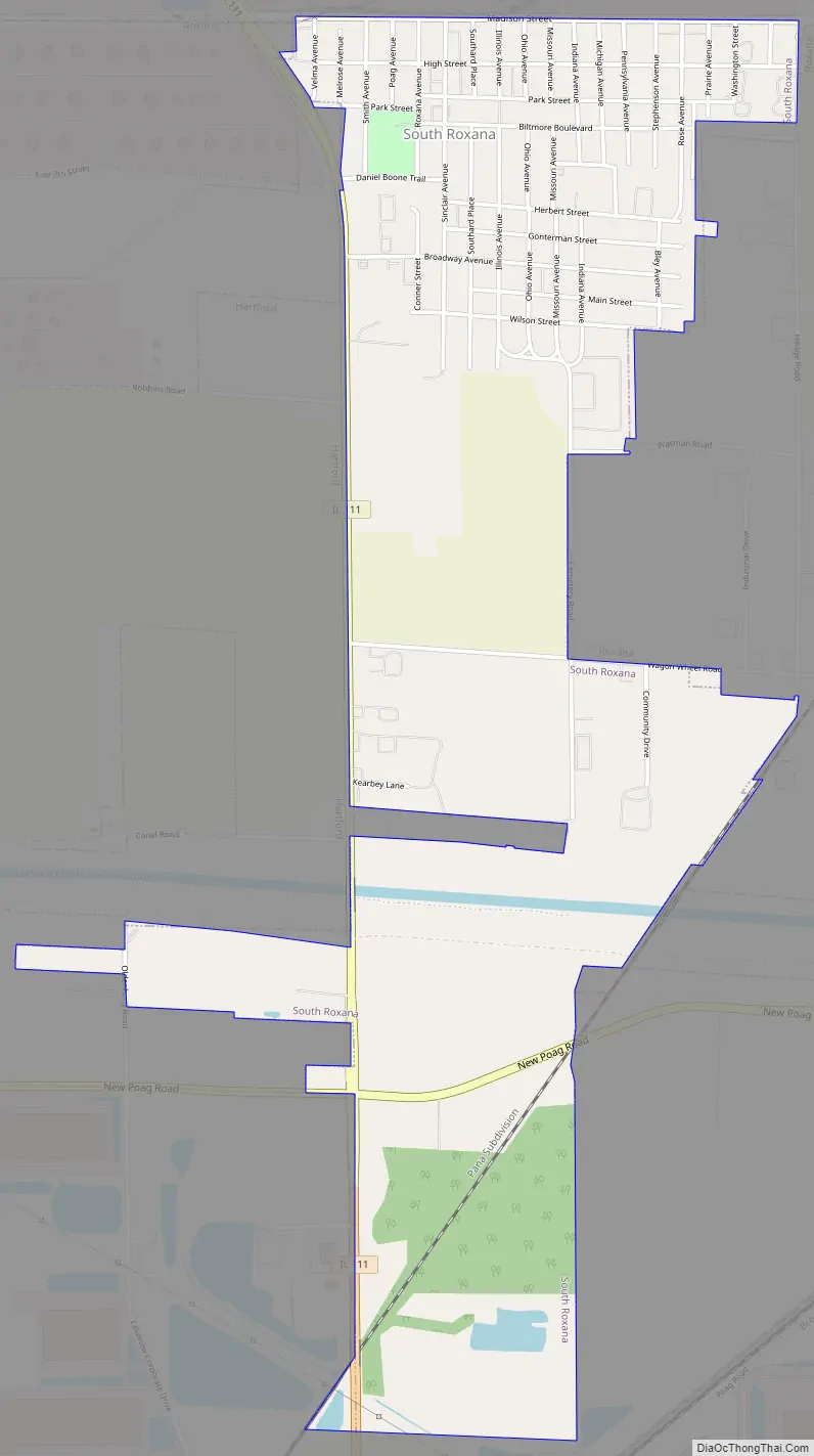
Online Interactive Map
Click on ![]() to view map in "full screen" mode.
to view map in "full screen" mode.
South Roxana location map. Where is South Roxana village?


South Roxana Road Map
South Roxana city Satellite Map

Geography
South Roxana is bordered to the north and east by the village of Roxana, to the south by a western extension of the city of Edwardsville, and to the west by the village of Hartford.
Illinois Route 111 runs along the western edge of South Roxana, leading north 2 miles (3 km) to Wood River and south 6 miles (10 km) to Pontoon Beach. Downtown St. Louis is 20 miles (32 km) to the south-southwest. Illinois Route 255, a four-lane expressway, passes just east of the village limits, with access from Exits 3 and 5. Route 255 leads south 4 miles (6 km) to Interstates 255 and 270 and north 6 miles (10 km) to Bethalto.
According to the U.S. Census Bureau, South Roxana has a total area of 2.3 square miles (6.0 km), of which 0.1 square miles (0.3 km), or 4.51%, are water.
See also
Map of Illinois State and its subdivision:- Adams
- Alexander
- Bond
- Boone
- Brown
- Bureau
- Calhoun
- Carroll
- Cass
- Champaign
- Christian
- Clark
- Clay
- Clinton
- Coles
- Cook
- Crawford
- Cumberland
- De Kalb
- De Witt
- Douglas
- Dupage
- Edgar
- Edwards
- Effingham
- Fayette
- Ford
- Franklin
- Fulton
- Gallatin
- Greene
- Grundy
- Hamilton
- Hancock
- Hardin
- Henderson
- Henry
- Iroquois
- Jackson
- Jasper
- Jefferson
- Jersey
- Jo Daviess
- Johnson
- Kane
- Kankakee
- Kendall
- Knox
- La Salle
- Lake
- Lake Michigan
- Lawrence
- Lee
- Livingston
- Logan
- Macon
- Macoupin
- Madison
- Marion
- Marshall
- Mason
- Massac
- McDonough
- McHenry
- McLean
- Menard
- Mercer
- Monroe
- Montgomery
- Morgan
- Moultrie
- Ogle
- Peoria
- Perry
- Piatt
- Pike
- Pope
- Pulaski
- Putnam
- Randolph
- Richland
- Rock Island
- Saint Clair
- Saline
- Sangamon
- Schuyler
- Scott
- Shelby
- Stark
- Stephenson
- Tazewell
- Union
- Vermilion
- Wabash
- Warren
- Washington
- Wayne
- White
- Whiteside
- Will
- Williamson
- Winnebago
- Woodford
- Alabama
- Alaska
- Arizona
- Arkansas
- California
- Colorado
- Connecticut
- Delaware
- District of Columbia
- Florida
- Georgia
- Hawaii
- Idaho
- Illinois
- Indiana
- Iowa
- Kansas
- Kentucky
- Louisiana
- Maine
- Maryland
- Massachusetts
- Michigan
- Minnesota
- Mississippi
- Missouri
- Montana
- Nebraska
- Nevada
- New Hampshire
- New Jersey
- New Mexico
- New York
- North Carolina
- North Dakota
- Ohio
- Oklahoma
- Oregon
- Pennsylvania
- Rhode Island
- South Carolina
- South Dakota
- Tennessee
- Texas
- Utah
- Vermont
- Virginia
- Washington
- West Virginia
- Wisconsin
- Wyoming


