South Holland is a village and south suburb of Chicago in Cook County, Illinois, United States, within Thornton Township. The population was 21,465 at the 2020 census.
| Name: | South Holland village |
|---|---|
| LSAD Code: | 47 |
| LSAD Description: | village (suffix) |
| State: | Illinois |
| County: | Cook County |
| Incorporated: | May 12, 1894 |
| Elevation: | 601 ft (183 m) |
| Total Area: | 7.25 sq mi (18.78 km²) |
| Land Area: | 7.24 sq mi (18.74 km²) |
| Water Area: | 0.02 sq mi (0.04 km²) 0.27% |
| Total Population: | 21,465 |
| Population Density: | 2,966.42/sq mi (1,145.36/km²) |
| ZIP code: | 60473 |
| Area code: | 708 |
| FIPS code: | 1770850 |
| GNISfeature ID: | 0418788 |
| Website: | www.southholland.org |
Online Interactive Map
Click on ![]() to view map in "full screen" mode.
to view map in "full screen" mode.
South Holland location map. Where is South Holland village?


History
The area currently occupied by South Holland, Illinois, was first settled in 1846 by immigrants from South Holland, Netherlands. When the community formally incorporated as a village in 1894, its population was about 1,000. Originally a general farming community, it later specialized in vegetable growing, especially onion sets. By the 1940s South Holland was known as the “Onion Set Capital of the World”. The town was built on low ground near the Calumet River and was originally called de Laage Prairie (Low Prairie) to differentiate it from another Dutch settlement further north on higher ground and called de Hooge Prairie (now the Roseland neighborhood of Chicago).
In October 2007, Forbes.com declared South Holland to be the “Most Livable Metro-Area suburb” of the Chicago metropolitan area.
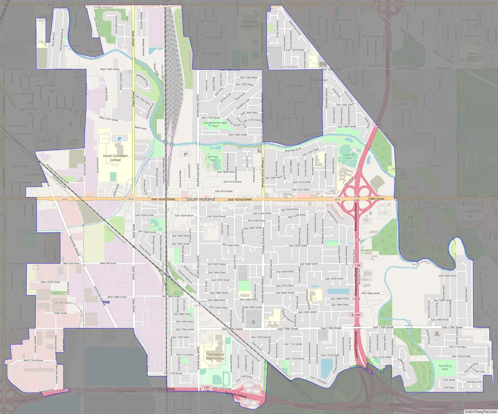
South Holland Road Map
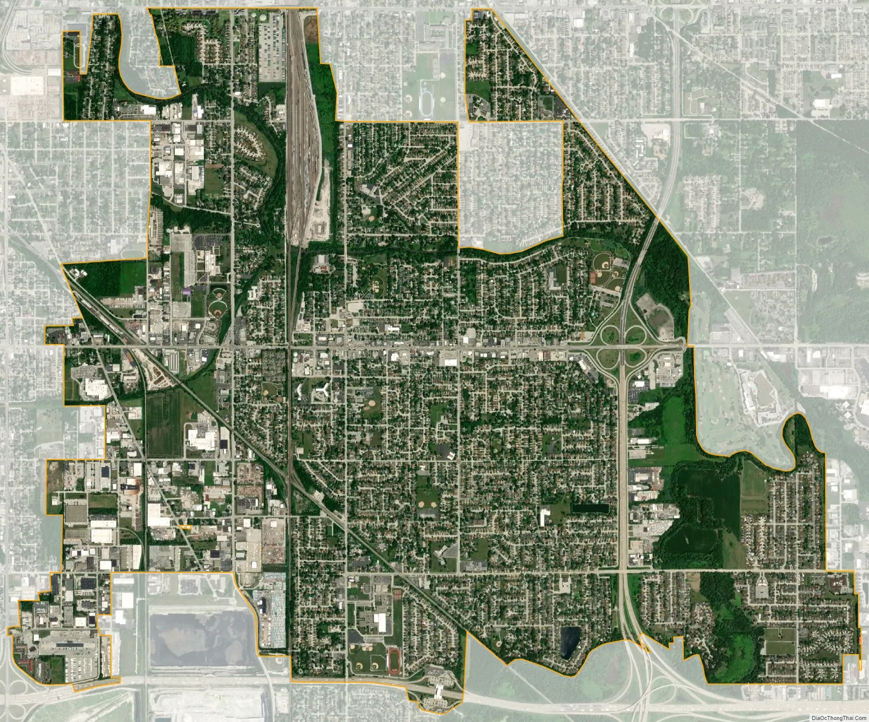
South Holland city Satellite Map
Geography
South Holland is located at 41°36′N 87°36′W / 41.600°N 87.600°W / 41.600; -87.600 (41.60, -87.60). It is bordered by Harvey and Phoenix to the west, Dolton to the north, Thornton to the south, and Calumet City and Lansing to the east.
According to the 2010 census, South Holland has a total area of 7.286 square miles (18.87 km), of which 7.27 square miles (18.83 km) (or 99.78%) is land and 0.016 square miles (0.04 km) (or 0.22%) is water.
South Holland’s addresses and numbered streets are 3 blocks ahead of Chicago’s grid. For example, 159th Street is actually called 162nd Street.
Surrounding areas
See also
Map of Illinois State and its subdivision:- Adams
- Alexander
- Bond
- Boone
- Brown
- Bureau
- Calhoun
- Carroll
- Cass
- Champaign
- Christian
- Clark
- Clay
- Clinton
- Coles
- Cook
- Crawford
- Cumberland
- De Kalb
- De Witt
- Douglas
- Dupage
- Edgar
- Edwards
- Effingham
- Fayette
- Ford
- Franklin
- Fulton
- Gallatin
- Greene
- Grundy
- Hamilton
- Hancock
- Hardin
- Henderson
- Henry
- Iroquois
- Jackson
- Jasper
- Jefferson
- Jersey
- Jo Daviess
- Johnson
- Kane
- Kankakee
- Kendall
- Knox
- La Salle
- Lake
- Lake Michigan
- Lawrence
- Lee
- Livingston
- Logan
- Macon
- Macoupin
- Madison
- Marion
- Marshall
- Mason
- Massac
- McDonough
- McHenry
- McLean
- Menard
- Mercer
- Monroe
- Montgomery
- Morgan
- Moultrie
- Ogle
- Peoria
- Perry
- Piatt
- Pike
- Pope
- Pulaski
- Putnam
- Randolph
- Richland
- Rock Island
- Saint Clair
- Saline
- Sangamon
- Schuyler
- Scott
- Shelby
- Stark
- Stephenson
- Tazewell
- Union
- Vermilion
- Wabash
- Warren
- Washington
- Wayne
- White
- Whiteside
- Will
- Williamson
- Winnebago
- Woodford
- Alabama
- Alaska
- Arizona
- Arkansas
- California
- Colorado
- Connecticut
- Delaware
- District of Columbia
- Florida
- Georgia
- Hawaii
- Idaho
- Illinois
- Indiana
- Iowa
- Kansas
- Kentucky
- Louisiana
- Maine
- Maryland
- Massachusetts
- Michigan
- Minnesota
- Mississippi
- Missouri
- Montana
- Nebraska
- Nevada
- New Hampshire
- New Jersey
- New Mexico
- New York
- North Carolina
- North Dakota
- Ohio
- Oklahoma
- Oregon
- Pennsylvania
- Rhode Island
- South Carolina
- South Dakota
- Tennessee
- Texas
- Utah
- Vermont
- Virginia
- Washington
- West Virginia
- Wisconsin
- Wyoming


