Map of Park View CDP

Map of Park View CDP

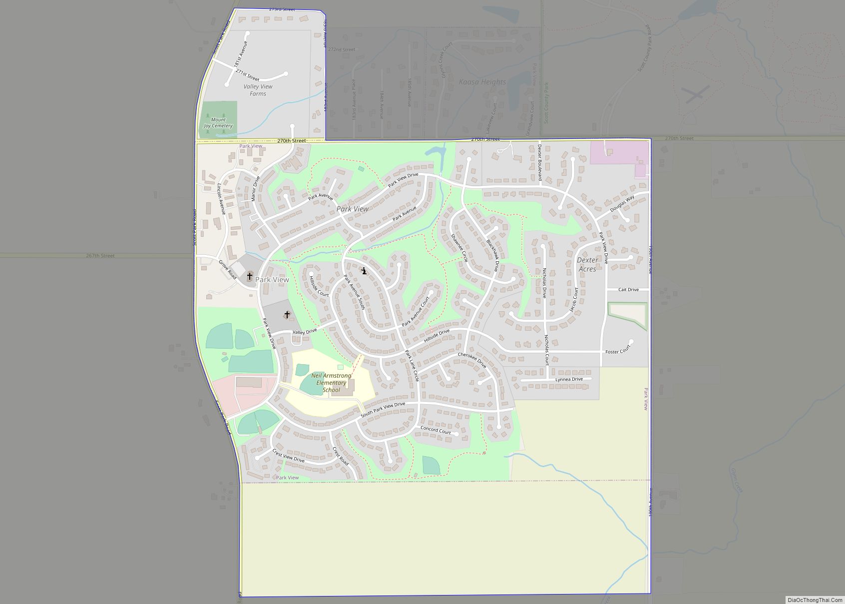
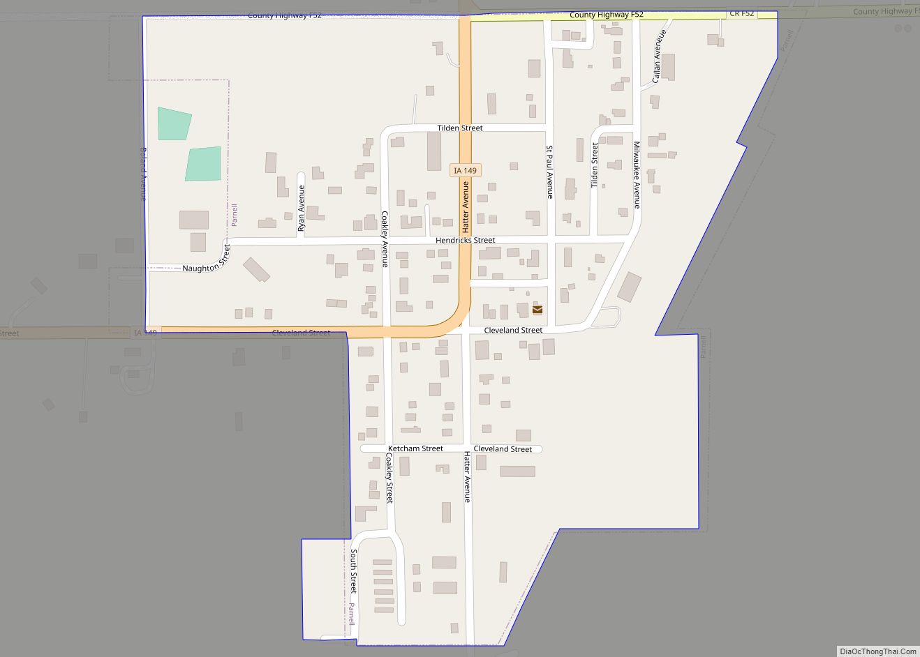
Park View is a census-designated place (CDP) in Scott County, Iowa, United States. The population was 2,389 at the 2010 census. Park View CDP overview: Name: Park View CDP LSAD Code: 57 LSAD Description: CDP (suffix) State: Iowa County: Scott County Elevation: 784 ft (239 m) Land Area: 1.48 sq mi (3.82 km²) Water Area: 0.01 sq mi (0.01 km²) Population Density: 1,835.37/sq mi … Read more

Map of Panorama Park city

Map of Panorama Park city

Panorama Park is a city in Scott County, Iowa, United States. The population was 139 at the time of the 2020 census. It is surrounded by Bettendorf, and is part of the Quad Cities metro area. Panorama Park city overview: Name: Panorama Park city LSAD Code: 25 LSAD Description: city (suffix) State: Iowa County: Scott … Read more

Map of Patterson city, Iowa

Map of Patterson city, Iowa

Patterson is a city in Madison County, Iowa, United States. The population was 176 at the time of the 2020 census. It is part of the Des Moines–West Des Moines Metropolitan Statistical Area. Patterson city overview: Name: Patterson city LSAD Code: 25 LSAD Description: city (suffix) State: Iowa County: Madison County Elevation: 889 ft (271 m) Total … Read more

Map of Paton city

Map of Paton city

Paton is a city in Greene County, Iowa, United States. The population was 221 at the time of the 2020 census. Paton city overview: Name: Paton city LSAD Code: 25 LSAD Description: city (suffix) State: Iowa County: Greene County Elevation: 1,102 ft (336 m) Total Area: 0.56 sq mi (1.46 km²) Land Area: 0.56 sq mi (1.46 km²) Water Area: 0.00 sq mi (0.00 km²) Total … Read more

Map of Parnell city

Map of Parnell city, Iowa

Parnell is a city in Iowa County, Iowa, United States. The population was 194 at the time of the 2020 census. Parnell city overview: Name: Parnell city LSAD Code: 25 LSAD Description: city (suffix) State: Iowa County: Iowa County Elevation: 863 ft (263 m) Total Area: 0.18 sq mi (0.46 km²) Land Area: 0.18 sq mi (0.46 km²) Water Area: 0.00 sq mi (0.00 km²) Total … Read more

Map of Peosta city

Map of Peosta city

Peosta is a city in Dubuque County, Iowa, United States, and an exurb of the city of Dubuque. It is part of the Dubuque, Iowa Metropolitan Statistical Area. The population was 1,908 in the 2020 census, an increase of 193% from 651 in 2000. Peosta experienced a 70% increase in population (estimated) from 2000 to … Read more

Map of Pella city

Map of Pella city, Iowa

Pella is a city in Marion County, Iowa, United States, with a population of 10,464 at the time of the 2020 U.S. Census. Founded by immigrants from the Netherlands, it is forty miles southeast of Des Moines. Pella is the home of Central College, as well as several manufacturing companies, including Pella Corporation and Vermeer … Read more

Map of Paullina city

Map of Paullina city

Paullina is a city in O’Brien County, Iowa, United States. The population was 982 at the 2020 census. Paullina city overview: Name: Paullina city LSAD Code: 25 LSAD Description: city (suffix) State: Iowa County: O’Brien County Elevation: 1,411 ft (430 m) Total Area: 0.93 sq mi (2.42 km²) Land Area: 0.93 sq mi (2.42 km²) Water Area: 0.00 sq mi (0.00 km²) Total Population: 982 Population … Read more

Map of Persia city

Map of Persia city

Persia is a city in Harrison County, Iowa, United States. The population was 297 in the 2020 census, a decline from 363 in the 2000 census. Persia city overview: Name: Persia city LSAD Code: 25 LSAD Description: city (suffix) State: Iowa County: Harrison County Elevation: 1,175 ft (358 m) Total Area: 0.50 sq mi (1.30 km²) Land Area: 0.50 sq mi (1.30 km²) … Read more

Map of Perry city, Iowa

Map of Perry city, Iowa

Perry is a city in Dallas County, Iowa, United States, along the North Raccoon River. The population was 7,836 at the time of the 2020 Census. It is part of the Des Moines–West Des Moines Metropolitan Statistical Area. Formerly a major railroad junction, Perry is home to the Historic Hotel Pattee, with themed rooms including … Read more

Map of Percival CDP

Map of Percival CDP

Percival CDP overview: Name: Percival CDP LSAD Code: 57 LSAD Description: CDP (suffix) State: Iowa County: Fremont County FIPS code: 1962175 Online Interactive Map Percival online map. Source: Basemap layers from Google Map, Open Street Map (OSM), Arcgisonline, Wmflabs. Boundary Data from Database of Global Administrative Areas. Percival location map. Where is Percival CDP? Percival … Read more

Map of Pilot Mound city

Map of Pilot Mound city

Pilot Mound is a city in Pilot Mound Township, Boone County, Iowa, United States. The population was 163 at the time of the 2020 census. It is part of the Boone, Iowa Micropolitan Statistical Area, which is a part of the larger Ames-Boone, Iowa Combined Statistical Area. Pilot Mound city overview: Name: Pilot Mound city … Read more