Map of Pocahontas city, Iowa
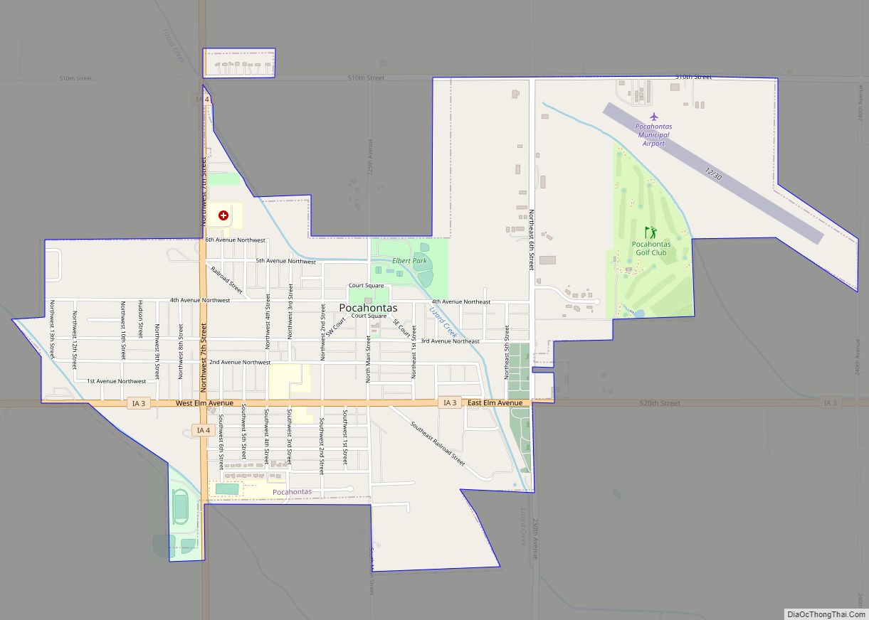
Pocahontas is a city in and the county seat of Pocahontas County, Iowa, United States. The population was 1,867 in the 2020 census, a decline from the 1,970 population in 2000. Pocahontas city overview: Name: Pocahontas city LSAD Code: 25 LSAD Description: city (suffix) State: Iowa County: Pocahontas County Incorporated: May 16, 1892 Elevation: 1,220 ft ... Read more
Map of Pocahontas city, Iowa
Map of Plymouth city, Iowa
Plymouth is a city in Cerro Gordo County, Iowa, United States, along the Shell Rock River. The population was 375 at the time of the 2020 census. It is part of the Mason City Micropolitan Statistical Area. Plymouth city overview: Name: Plymouth city LSAD Code: 25 LSAD Description: city (suffix) State: Iowa County: Cerro Gordo ... Read more
Map of Plymouth city, Iowa
Map of Portland CDP, Iowa
Portland is an unincorporated community and census-designated place (CDP) in Portland Township, Cerro Gordo County, Iowa, United States. As of the 2010 census it had a population of 35. Portland CDP overview: Name: Portland CDP LSAD Code: 57 LSAD Description: CDP (suffix) State: Iowa County: Cerro Gordo County Elevation: 1,078 ft (329 m) Total Area: 1.01 sq mi (2.61 km²) ... Read more
Map of Portland CDP, Iowa
Map of Popejoy city
Popejoy is a city in Franklin County, Iowa, United States. The population was 77 at the time of the 2020 census. Popejoy city overview: Name: Popejoy city LSAD Code: 25 LSAD Description: city (suffix) State: Iowa County: Franklin County Elevation: 1,158 ft (353 m) Total Area: 0.75 sq mi (1.95 km²) Land Area: 0.75 sq mi (1.95 km²) Water Area: 0.00 sq mi (0.00 km²) Total ... Read more
Map of Popejoy city
Map of Pomeroy city, Iowa
Pomeroy is a city in Calhoun County, Iowa, United States. The population was 526 at the time of the 2020 census. Pomeroy city overview: Name: Pomeroy city LSAD Code: 25 LSAD Description: city (suffix) State: Iowa County: Calhoun County Elevation: 1,240 ft (378 m) Total Area: 2.05 sq mi (5.30 km²) Land Area: 2.05 sq mi (5.30 km²) Water Area: 0.00 sq mi (0.00 km²) Total ... Read more
Map of Pomeroy city, Iowa
Map of Prairie City, Iowa
Prairie City is a city in Jasper County, Iowa, United States. The population was 1,700 at the time of the 2020 census. It is twenty-two miles east of Des Moines. Prairie City city overview: Name: Prairie City city LSAD Code: 25 LSAD Description: city (suffix) State: Iowa County: Jasper County Elevation: 928 ft (283 m) Total Area: ... Read more
Map of Prairie City, Iowa
Map of Postville city
Postville is a village in Allamakee and Clayton counties in the U.S. state of Iowa. It lies near the junction of four counties and at the intersection of U.S. Routes 18 and 52 and Iowa Highway 51, with airport facilities in the neighboring communities of Waukon, Decorah, Monona and Prairie du Chien. The population was ... Read more
Map of Postville city
Map of Portsmouth city, Iowa
Portsmouth is a city in Shelby County, Iowa, United States. The population was 182 at the time of the 2020 census. Portsmouth city overview: Name: Portsmouth city LSAD Code: 25 LSAD Description: city (suffix) State: Iowa County: Shelby County Elevation: 1,224 ft (373 m) Total Area: 0.29 sq mi (0.77 km²) Land Area: 0.29 sq mi (0.77 km²) Water Area: 0.00 sq mi (0.00 km²) Total ... Read more
Map of Portsmouth city, Iowa
Map of Preston city, Iowa
Preston is a city in Jackson County, Iowa, United States. The population was 949 at the time of the 2020 census. Preston city overview: Name: Preston city LSAD Code: 25 LSAD Description: city (suffix) State: Iowa County: Jackson County Elevation: 646 ft (197 m) Total Area: 0.86 sq mi (2.23 km²) Land Area: 0.86 sq mi (2.23 km²) Water Area: 0.00 sq mi (0.00 km²) Total ... Read more
Map of Preston city, Iowa
Map of Prescott city, Iowa
Prescott is a city in Prescott Township, Adams County, Iowa, United States. The population was 191 at the time of the 2020 census. Prescott city overview: Name: Prescott city LSAD Code: 25 LSAD Description: city (suffix) State: Iowa County: Adams County Elevation: 1,194 ft (364 m) Total Area: 0.43 sq mi (1.12 km²) Land Area: 0.43 sq mi (1.12 km²) Water Area: 0.00 sq mi ... Read more
Map of Prescott city, Iowa
Map of Prairieburg city
Prairieburg is a city in Linn County, Iowa, United States. The population was 160 at the time of the 2020 census. It is part of the Cedar Rapids Metropolitan Statistical Area. Prairieburg city overview: Name: Prairieburg city LSAD Code: 25 LSAD Description: city (suffix) State: Iowa County: Linn County Elevation: 1,001 ft (305 m) Total Area: 0.45 sq mi ... Read more
Map of Prairieburg city
Map of Promise City
Promise City is a city in Wayne County, Iowa, United States. The population was 88 at the time of the 2020 census. Promise City city overview: Name: Promise City city LSAD Code: 25 LSAD Description: city (suffix) State: Iowa County: Wayne County Elevation: 1,053 ft (321 m) Total Area: 0.19 sq mi (0.49 km²) Land Area: 0.18 sq mi (0.48 km²) Water Area: ... Read more
Map of Promise City