Map of Shell Rock city

Map of Shell Rock city

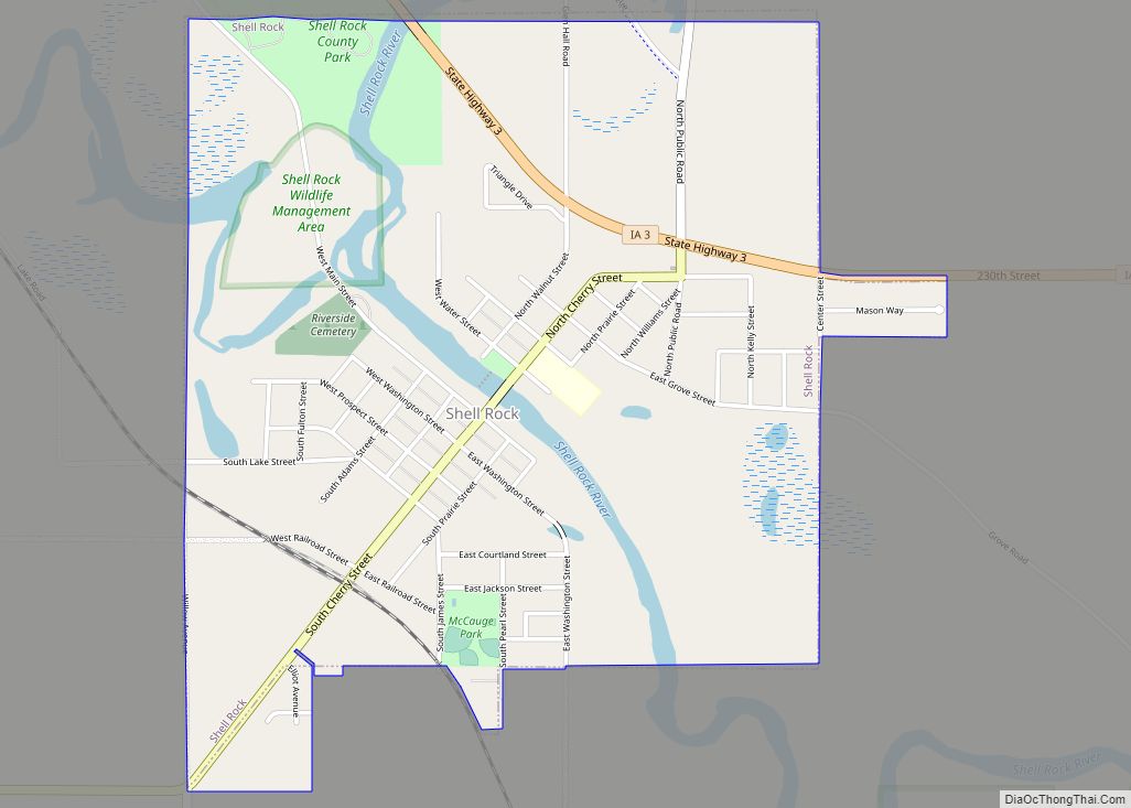
Shell Rock is a city in Butler County, Iowa, United States, along the Shell Rock River. The population was 1,268 at the time of the 2020 census. The city is located along the county’s eastern border, between Butler and Bremer counties. Shell Rock city overview: Name: Shell Rock city LSAD Code: 25 LSAD Description: city … Read more

Map of Sheldon city

Map of Sheldon city, Iowa

Sheldon is a city in O’Brien and Sioux counties in the U.S. state of Iowa, along the Floyd River. The population was 5,512 at the time of the 2020 census; it is the largest city in O’Brien County. Sheldon city overview: Name: Sheldon city LSAD Code: 25 LSAD Description: city (suffix) State: Iowa County: O’Brien … Read more

Map of Shueyville city

Map of Shueyville city

Shueyville is a city in Johnson County, Iowa, United States. It is part of the Iowa City, Iowa Metropolitan Statistical Area. The population was 731 at the time of the 2020 census. Shueyville city overview: Name: Shueyville city LSAD Code: 25 LSAD Description: city (suffix) State: Iowa County: Johnson County Elevation: 801 ft (244 m) Total Area: … Read more

Map of Sherrill city, Iowa

Map of Sherrill city, Iowa

Sherrill is a city in Dubuque County, Iowa, United States. The population was 189 at the time of the 2020 census, up from 186 in 2000. Sherrill city overview: Name: Sherrill city LSAD Code: 25 LSAD Description: city (suffix) State: Iowa County: Dubuque County Elevation: 981 ft (299 m) Total Area: 0.13 sq mi (0.34 km²) Land Area: 0.13 sq mi (0.34 km²) … Read more

Map of Shenandoah city

Map of Shenandoah city, Iowa

Shenandoah is a city in Page and Fremont counties in Iowa, United States. The population was 4,925 at the time of the 2020 U.S. Census. Once referred to as the “seed and nursery center of the world,” Shenandoah is the home to Earl May Seed Company and the radio station KMA, founded by Earl E. … Read more

Map of Sigourney city

Map of Sigourney city

Sigourney (/ˈsɪɡərni/ SIG-ər-nee) is a city in Keokuk County, Iowa, United States. The population was 2,004 at the time of the 2020 census. It is the county seat of Keokuk County. Keokuk County Courthouse is located in the Public Square Historic District. Both are on the National Register of Historic Places. Sigourney city overview: Name: … Read more

Map of Sidney city, Iowa

Map of Sidney city, Iowa

Sidney is a city in Fremont County, Iowa, United States. The population was 1,070 at the time of the 2020 census. It is the county seat of Fremont County and is one of the smallest county seats in the state. Sidney city overview: Name: Sidney city LSAD Code: 25 LSAD Description: city (suffix) State: Iowa … Read more

Map of Sibley city

Map of Sibley city, Iowa

Sibley is a city in Osceola County, Iowa, United States. The population was 2,860 at the time of the 2020 census. It is the county seat of Osceola County. Hawkeye Point, the highest point in the State of Iowa, is also nearby. Sibley city overview: Name: Sibley city LSAD Code: 25 LSAD Description: city (suffix) … Read more

Map of Sioux Rapids city

Map of Sioux Rapids city

Sioux Rapids is a city in Buena Vista County, Iowa, United States. The population was 748 at the time of the 2020 census. Sioux Rapids city overview: Name: Sioux Rapids city LSAD Code: 25 LSAD Description: city (suffix) State: Iowa County: Buena Vista County Elevation: 1,260 ft (384 m) Total Area: 0.82 sq mi (2.12 km²) Land Area: 0.82 sq mi (2.12 km²) … Read more

Map of Sioux Center city

Map of Sioux Center city

Sioux Center is a city in Sioux County, Iowa. The population was 8,229 at the time of the 2020 census. Sioux Center is notable for its Dutch heritage, agribusiness, and as the location of Dordt University. Sioux Center city overview: Name: Sioux Center city LSAD Code: 25 LSAD Description: city (suffix) State: Iowa County: Sioux … Read more

Map of Silver City, Iowa

Map of Silver City, Iowa

Silver City is a city in Mills County, Iowa, United States. The population was 245 at the 2020 census. The Wabash Trace—a railroad converted to a bicycle trail—passes through here. At trailside, there is a small park with a gazebo, and across from it, a small cafe. Silver City overview: Name: Silver City LSAD Code: … Read more

Map of Smithland city

Map of Smithland city, Iowa

Smithland is a city in Woodbury County, Iowa, United States. It is part of the Sioux City, IA–NE–SD Metropolitan Statistical Area. The population was 181 at the time of the 2020 census. Smithland city overview: Name: Smithland city LSAD Code: 25 LSAD Description: city (suffix) State: Iowa County: Woodbury County Elevation: 1,086 ft (331 m) Total Area: … Read more