Map of West Okoboji city

Map of West Okoboji city

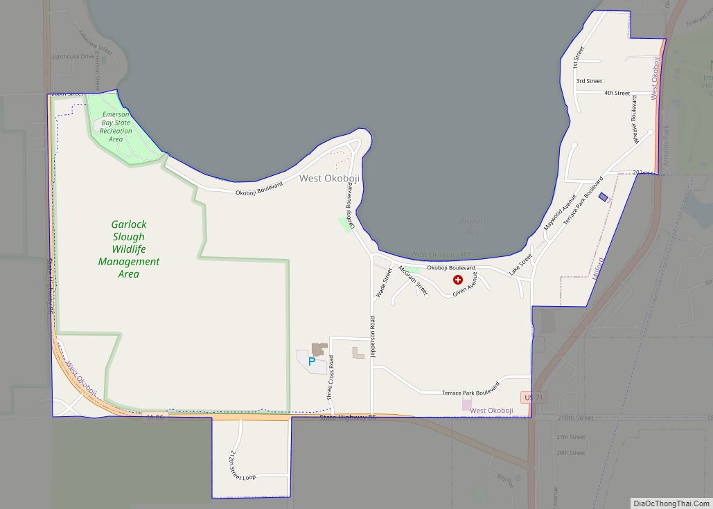
West Okoboji is a city in Dickinson County, Iowa, United States. The population was 308 at the time of the 2020 census. The city is located on West Okoboji Lake, from which it takes its name. It is part of the Iowa Great Lakes region. West Okoboji city overview: Name: West Okoboji city LSAD Code: … Read more

Map of West Liberty city

Map of West Liberty city, Iowa

West Liberty is a city in Muscatine County, Iowa, United States. The population was 3,858 at the time of the 2020 census. It is part of the Muscatine micropolitan area. West Liberty is located five miles south of Interstate 80 on Historic Highway 6. The city is home to the West Liberty Raceway, located in … Read more

Map of Westgate city, Iowa

Map of Westgate city, Iowa

Westgate is a city in Fayette County, Iowa, United States. The population was 192 at the time of the 2020 census, down from 234 in 2000. Westgate city overview: Name: Westgate city LSAD Code: 25 LSAD Description: city (suffix) State: Iowa County: Fayette County Elevation: 1,093 ft (333 m) Total Area: 0.36 sq mi (0.94 km²) Land Area: 0.36 sq mi (0.94 km²) … Read more

Map of Westfield city

Map of Westfield city, Iowa

Westfield is a city in Plymouth County, Iowa, United States. The population was 123 at the time of the 2020 census. It is the westernmost point in Iowa, this being due to a bend in the Big Sioux River. The nearby Broken Kettle wildlife refuge is one of the few places in Iowa where prairie … Read more

Map of West Union city

Map of West Union city, Iowa

West Union is a city in Fayette County, Iowa, United States. The population was 2,490 at the time of the 2020 census. It is the county seat of Fayette County. West Union city overview: Name: West Union city LSAD Code: 25 LSAD Description: city (suffix) State: Iowa County: Fayette County Elevation: 1,188 ft (362 m) Total Area: … Read more

Map of Westside city, Iowa

Map of Westside city, Iowa

Westside is a city in Crawford County, Iowa, United States. The population was 285 at the time of the 2020 census. Westside city overview: Name: Westside city LSAD Code: 25 LSAD Description: city (suffix) State: Iowa County: Crawford County Elevation: 1,394 ft (425 m) Total Area: 1.47 sq mi (3.81 km²) Land Area: 1.47 sq mi (3.81 km²) Water Area: 0.00 sq mi (0.00 km²) Total … Read more

Map of Westphalia city

Map of Westphalia city, Iowa

Westphalia is a city in Shelby County, Iowa, United States. The population was 126 at the time of the 2020 census. Westphalia city overview: Name: Westphalia city LSAD Code: 25 LSAD Description: city (suffix) State: Iowa County: Shelby County Elevation: 1,437 ft (438 m) Total Area: 0.10 sq mi (0.25 km²) Land Area: 0.10 sq mi (0.25 km²) Water Area: 0.00 sq mi (0.00 km²) Total … Read more

Map of Weston CDP, Iowa

Map of Weston CDP, Iowa

Weston is a census-designated place located in the southeastern portion of Hazel Dell Township in Pottawattamie County in the state of Iowa. As of the 2020 census the population was 78. Its location is almost exactly between the cities of Council Bluffs and Underwood near Interstate 80. Weston CDP overview: Name: Weston CDP LSAD Code: … Read more

Map of Wheatland city, Iowa

Map of Wheatland city, Iowa

Wheatland is a city in Clinton County, Iowa, United States. The population was 775 at the time of the 2020 census. Wheatland city overview: Name: Wheatland city LSAD Code: 25 LSAD Description: city (suffix) State: Iowa County: Clinton County Elevation: 689 ft (210 m) Total Area: 0.57 sq mi (1.49 km²) Land Area: 0.57 sq mi (1.49 km²) Water Area: 0.00 sq mi (0.00 km²) Total … Read more

Map of What Cheer city

Map of What Cheer city

What Cheer (/hwəˈtʃɪər, hwʌtˈtʃɪər, ˈhwɒtʃɪər, ˈhwættʃɪər/) is a city in Keokuk County, Iowa, United States. It is a former coal town, and from the 1870s to the early 1900s was one of the major coal-producing centers of Iowa. Its greatest recorded population was 3,246, in the 1890 census. The population was 607 in the 2020 … Read more

Map of Westwood city, Iowa

Map of Westwood city, Iowa

Westwood is a city in Henry County, Iowa, United States. The population was 101 at the time of the 2020 census. Westwood city overview: Name: Westwood city LSAD Code: 25 LSAD Description: city (suffix) State: Iowa County: Henry County Elevation: 699 ft (213 m) Total Area: 0.11 sq mi (0.29 km²) Land Area: 0.11 sq mi (0.28 km²) Water Area: 0.00 sq mi (0.01 km²) Total … Read more

Map of Whittemore city

Map of Whittemore city, Iowa

Whittemore is a city in Kossuth County, Iowa, United States. The population was 497 at the time of the 2020 census. Whittemore city overview: Name: Whittemore city LSAD Code: 25 LSAD Description: city (suffix) State: Iowa County: Kossuth County Elevation: 1,204 ft (367 m) Total Area: 0.41 sq mi (1.05 km²) Land Area: 0.41 sq mi (1.05 km²) Water Area: 0.00 sq mi (0.00 km²) Total … Read more