Map of Cherryvale city

Map of Cherryvale city, Kansas

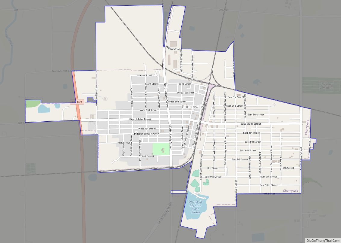
Cherryvale is a city in Montgomery County, Kansas, United States. As of the 2020 census, the population of the city was 2,192. Cherryvale city overview: Name: Cherryvale city LSAD Code: 25 LSAD Description: city (suffix) State: Kansas County: Montgomery County Founded: 1871 Incorporated: 1880 Elevation: 837 ft (255 m) Total Area: 2.03 sq mi (5.25 km²) Land Area: 2.00 sq mi (5.19 km²) … Read more

Map of Cherokee city, Kansas

Map of Cherokee city, Kansas

Cherokee is a city in Crawford County, Kansas, United States. As of the 2020 census, the population of the city was 590. Cherokee city overview: Name: Cherokee city LSAD Code: 25 LSAD Description: city (suffix) State: Kansas County: Crawford County Founded: 1870 Incorporated: 1874 Elevation: 948 ft (289 m) Total Area: 0.72 sq mi (1.85 km²) Land Area: 0.72 sq mi (1.85 km²) … Read more

Map of Cheney city

Map of Cheney city, Kansas

Cheney /ˈtʃiːni/ is a city in Sedgwick County, Kansas, United States. As of the 2020 census, the population of the city was 2,181. Cheney city overview: Name: Cheney city LSAD Code: 25 LSAD Description: city (suffix) State: Kansas County: Sedgwick County Founded: 1883 Incorporated: 1884 Elevation: 1,388 ft (423 m) Total Area: 2.32 sq mi (6.00 km²) Land Area: 2.32 sq mi … Read more

Map of Cimarron city

Map of Cimarron city, Kansas

Cimarron is a city in and the county seat of Gray County, Kansas, United States. As of the 2020 census, the population of the city was 1,981. Cimarron city overview: Name: Cimarron city LSAD Code: 25 LSAD Description: city (suffix) State: Kansas County: Gray County Founded: 1878 Incorporated: 1885 Elevation: 2,635 ft (803 m) Total Area: 1.15 sq mi … Read more

Map of Chicopee CDP

Map of Chicopee CDP, Kansas

Chicopee is an unincorporated community in Crawford County, Kansas, United States. As of the 2020 census, the population of the community and nearby areas was 422. Chicopee CDP overview: Name: Chicopee CDP LSAD Code: 57 LSAD Description: CDP (suffix) State: Kansas County: Crawford County Elevation: 919 ft (280 m) Total Area: 3.2 sq mi (8.3 km²) Land Area: 3.2 sq mi (8.2 km²) … Read more

Map of Chetopa city

Map of Chetopa city

Chetopa is a city in Labette County, Kansas, United States. As of the 2020 census, the population of the city was 929. Chetopa was named for Chief Chetopah, an Osage Indian chief. Later, the community name was shortened. Chetopa city overview: Name: Chetopa city LSAD Code: 25 LSAD Description: city (suffix) State: Kansas County: Labette … Read more

Map of Clay Center city

Map of Clay Center city, Kansas

Clay Center is a city in and the county seat of Clay County, Kansas, United States. As of the 2020 census, the population of the city was 4,199. Clay Center city overview: Name: Clay Center city LSAD Code: 25 LSAD Description: city (suffix) State: Kansas County: Clay County Founded: 1862 Incorporated: 1875 Elevation: 1,201 ft (366 m) … Read more

Map of Claflin city

Map of Claflin city

Claflin is a city in Barton County, Kansas, United States. As of the 2020 census, the population of the city was 562. Claflin city overview: Name: Claflin city LSAD Code: 25 LSAD Description: city (suffix) State: Kansas County: Barton County Founded: 1887 Incorporated: 1901 Elevation: 1,811 ft (552 m) Total Area: 0.33 sq mi (0.84 km²) Land Area: 0.33 sq mi (0.84 km²) … Read more

Map of Circleville city

Map of Circleville city, Kansas

Circleville is a city in Jackson County, Kansas, United States. As of the 2020 census, the population of the city was 153. Circleville city overview: Name: Circleville city LSAD Code: 25 LSAD Description: city (suffix) State: Kansas County: Jackson County Founded: 1863 Elevation: 1,135 ft (346 m) Total Area: 0.25 sq mi (0.66 km²) Land Area: 0.25 sq mi (0.66 km²) Water Area: … Read more

Map of Clifton city, Kansas

Map of Clifton city, Kansas

Clifton is a city in Clay and Washington counties in the U.S. state of Kansas. As of the 2020 census, the population of the city was 454. Clifton city overview: Name: Clifton city LSAD Code: 25 LSAD Description: city (suffix) State: Kansas County: Clay County, Washington County Founded: 1870 Incorporated: 1884 Elevation: 1,303 ft (397 m) Total … Read more

Map of Clearwater city, Kansas

Map of Clearwater city, Kansas

Clearwater is a city in Sedgwick County, Kansas, United States. As of the 2020 census, the population of the city was 2,653. Clearwater city overview: Name: Clearwater city LSAD Code: 25 LSAD Description: city (suffix) State: Kansas County: Sedgwick County Founded: 1870 Incorporated: 1885 Elevation: 1,286 ft (392 m) Total Area: 1.94 sq mi (5.02 km²) Land Area: 1.94 sq mi (5.02 km²) … Read more

Map of Clayton city, Kansas

Map of Clayton city, Kansas

Clayton is a city in Decatur and Norton counties in the U.S. state of Kansas. As of the 2020 census, the population of the city was 44. Clayton city overview: Name: Clayton city LSAD Code: 25 LSAD Description: city (suffix) State: Kansas County: Decatur County, Norton County Founded: 1870s Incorporated: 1907 Elevation: 2,421 ft (738 m) Total … Read more