Map of Highland city, Kansas

Map of Highland city, Kansas

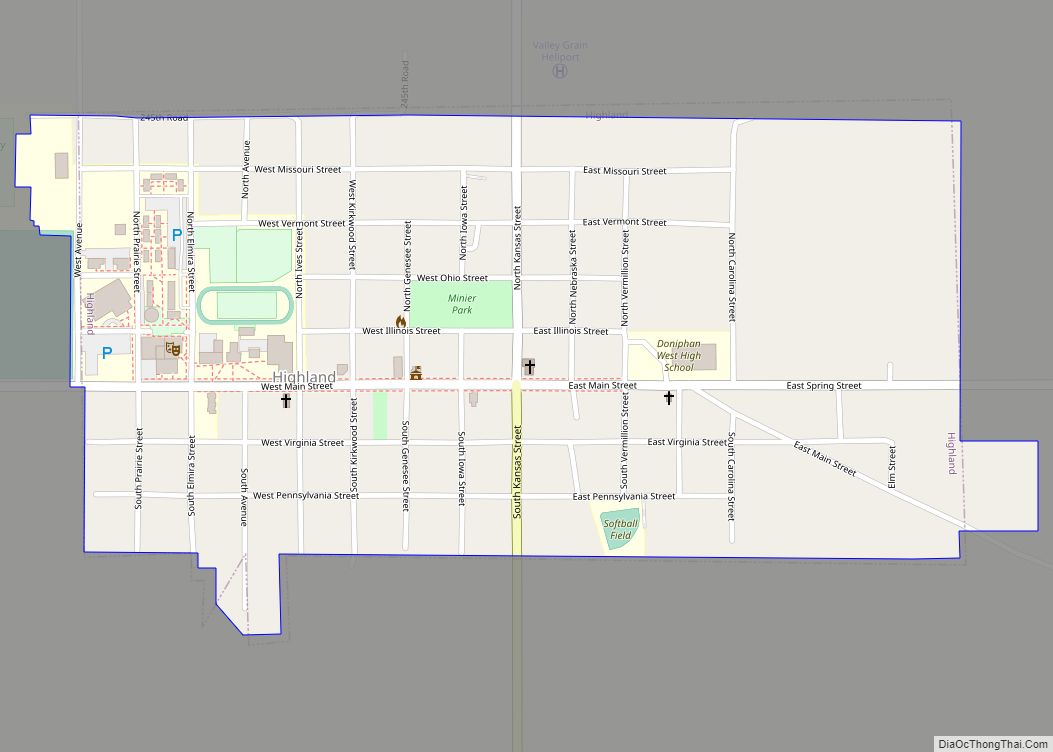
Highland is a city in Doniphan County, Kansas, United States. As of the 2020 census, the population of the city was 903. It is home to Highland Community College. Highland city overview: Name: Highland city LSAD Code: 25 LSAD Description: city (suffix) State: Kansas County: Doniphan County Founded: 1854 Incorporated: 1857 Elevation: 1,050 ft (320 m) Total … Read more

Map of Holcomb city

Map of Holcomb city, Kansas

Holcomb is a city in Finney County, Kansas, United States. As of the 2020 census, the population of the city was 2,245. Holcomb city overview: Name: Holcomb city LSAD Code: 25 LSAD Description: city (suffix) State: Kansas County: Finney County Founded: 1900s Incorporated: 1961 Elevation: 2,884 ft (879 m) Total Area: 1.24 sq mi (3.20 km²) Land Area: 1.24 sq mi (3.20 km²) … Read more

Map of Hoisington city

Map of Hoisington city

Hoisington is a city in Barton County, Kansas, United States. As of the 2020 census, the population of the city was 2,699. Hoisington city overview: Name: Hoisington city LSAD Code: 25 LSAD Description: city (suffix) State: Kansas County: Barton County Founded: 1886 Incorporated: 1887 Elevation: 1,844 ft (562 m) Total Area: 1.16 sq mi (3.00 km²) Land Area: 1.16 sq mi (3.00 km²) … Read more

Map of Hillsdale CDP, Kansas

Map of Hillsdale CDP, Kansas

Hillsdale is an unincorporated community in Miami County, Kansas, United States. As of the 2020 census, the population of the community and nearby areas was 247. Hillsdale is located near U.S. Route 169 and K-7 6 miles (9.7 km) north-northeast of Paola. It is part of the Kansas City metropolitan area. Hillsdale CDP overview: Name: Hillsdale … Read more

Map of Holyrood city

Map of Holyrood city

Holyrood is a city in Ellsworth County, Kansas, United States. As of the 2020 census, the population of the city was 403. Holyrood city overview: Name: Holyrood city LSAD Code: 25 LSAD Description: city (suffix) State: Kansas County: Ellsworth County Founded: 1874 Incorporated: 1901 Elevation: 1,808 ft (551 m) Total Area: 0.44 sq mi (1.13 km²) Land Area: 0.43 sq mi (1.11 km²) … Read more

Map of Holton city, Kansas

Map of Holton city, Kansas

Holton is a city in and the county seat of Jackson County, Kansas, United States. As of the 2020 census, the population of the city was 3,401. Holton city overview: Name: Holton city LSAD Code: 25 LSAD Description: city (suffix) State: Kansas County: Jackson County Founded: 1856 Incorporated: 1859 Elevation: 1,096 ft (334 m) Total Area: 2.76 sq mi … Read more

Map of Hollenberg city

Map of Hollenberg city

Hollenberg is a city in Washington County, Kansas, United States. As of the 2020 census, the population of the city was 10. It is located 1.5 miles south of the Nebraska state line. Hollenberg city overview: Name: Hollenberg city LSAD Code: 25 LSAD Description: city (suffix) State: Kansas County: Washington County Founded: 1872 Incorporated: 1937 … Read more

Map of Home CDP

Map of Home CDP, Kansas

Home (also called Home City) is an unincorporated community in southern Franklin Township, Marshall County, Kansas, United States. As of the 2020 census, the population of the community and nearby areas was 154. It lies along U.S. Route 36 – the Pony Express Highway – and a Union Pacific rail line, east of the city … Read more

Map of Horace city

Map of Horace city, Kansas

Horace is a city in Greeley County, Kansas, United States. As of the 2020 census, the population of the city was 102. Horace city overview: Name: Horace city LSAD Code: 25 LSAD Description: city (suffix) State: Kansas County: Greeley County Founded: 1886 Incorporated: 1887 Elevation: 3,642 ft (1,110 m) Total Area: 0.24 sq mi (0.63 km²) Land Area: 0.24 sq mi (0.63 km²) … Read more

Map of Hope city, Kansas

Map of Hope city, Kansas

Hope is a city in southern Dickinson County, Kansas, United States. As of the 2020 census, the population of the city was 317. Hope city overview: Name: Hope city LSAD Code: 25 LSAD Description: city (suffix) State: Kansas County: Dickinson County Founded: 1871 Incorporated: 1886 Elevation: 1,398 ft (426 m) Total Area: 0.39 sq mi (1.01 km²) Land Area: 0.39 sq mi … Read more

Map of Hoxie city, Kansas

Map of Hoxie city, Kansas

Hoxie is a city in and the county seat of Sheridan County, Kansas, United States. As of the 2020 census, the population of the city was 1,211. Hoxie city overview: Name: Hoxie city LSAD Code: 25 LSAD Description: city (suffix) State: Kansas County: Sheridan County Founded: 1886 Incorporated: 1886 Elevation: 2,713 ft (827 m) Total Area: 0.86 sq mi … Read more

Map of Howard city, Kansas

Map of Howard city, Kansas

Howard is a city in and the county seat of Elk County, Kansas, United States. As of the 2020 census, the population of the city was 570. Howard city overview: Name: Howard city LSAD Code: 25 LSAD Description: city (suffix) State: Kansas County: Elk County Founded: 1870 Incorporated: 1877 Elevation: 1,037 ft (316 m) Total Area: 0.69 sq mi … Read more