Map of Lincoln Center city
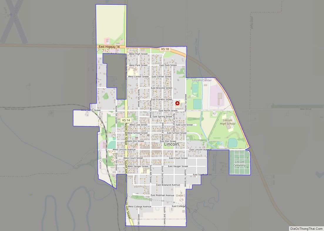
Lincoln Center, more commonly known as Lincoln, is a city in and the county seat of Lincoln County, Kansas, United States. As of the 2020 census, the population of the city was 1,171. Lincoln Center city overview: Name: Lincoln Center city LSAD Code: 25 LSAD Description: city (suffix) State: Kansas County: Lincoln County Founded: 1870 ... Read more
Map of Lincoln Center city
Map of Linn city, Kansas
Linn is a city in Washington County, Kansas, United States. As of the 2020 census, the population of the city was 387. Linn city overview: Name: Linn city LSAD Code: 25 LSAD Description: city (suffix) State: Kansas County: Washington County Founded: 1877 Incorporated: 1911 Elevation: 1,460 ft (450 m) Total Area: 0.34 sq mi (0.88 km²) Land Area: 0.34 sq mi (0.88 km²) ... Read more
Map of Linn city, Kansas
Map of Linn Valley city
Linn Valley is a city in Linn County, Kansas, United States. As of the 2020 census, the population of the city was 956. Linn Valley city overview: Name: Linn Valley city LSAD Code: 25 LSAD Description: city (suffix) State: Kansas County: Linn County Founded: 1970s Incorporated: 1998 Elevation: 899 ft (274 m) Total Area: 3.21 sq mi (8.32 km²) Land ... Read more
Map of Linn Valley city
Map of Linwood city, Kansas
Linwood is a city in Leavenworth County, Kansas, United States, and part of the Kansas City metropolitan area. As of the 2020 census, the population of the city was 415. It is located along K-32 highway between Lawrence and Bonner Springs. Linwood city overview: Name: Linwood city LSAD Code: 25 LSAD Description: city (suffix) State: ... Read more
Map of Linwood city, Kansas
Map of Lone Elm city
Lone Elm is a city in Anderson County, Kansas, United States. As of the 2020 census, the population of the city was 27. Lone Elm city overview: Name: Lone Elm city LSAD Code: 25 LSAD Description: city (suffix) State: Kansas County: Anderson County Founded: 1870s Incorporated: 1924 Elevation: 1,106 ft (337 m) Total Area: 0.07 sq mi (0.18 km²) Land ... Read more
Map of Lone Elm city
Map of Logan city, Kansas
Logan is a city in Phillips County, Kansas, United States. As of the 2020 census, the population of the city was 460. Logan city overview: Name: Logan city LSAD Code: 25 LSAD Description: city (suffix) State: Kansas County: Phillips County Founded: 1870 Incorporated: 1880 Elevation: 1,969 ft (600 m) Total Area: 1.50 sq mi (3.89 km²) Land Area: 1.50 sq mi (3.89 km²) ... Read more
Map of Logan city, Kansas
Map of Little River city, Kansas
Little River is a city in Rice County, Kansas, United States. As of the 2020 census, the population of the city was 472. Little River city overview: Name: Little River city LSAD Code: 25 LSAD Description: city (suffix) State: Kansas County: Rice County Founded: 1880 Incorporated: 1886 Elevation: 1,608 ft (490 m) Total Area: 0.39 sq mi (1.01 km²) Land ... Read more
Map of Little River city, Kansas
Map of Longton city
Longton is a city in Elk County, Kansas, United States, along the Elk River. As of the 2020 census, the population of the city was 288. Longton city overview: Name: Longton city LSAD Code: 25 LSAD Description: city (suffix) State: Kansas County: Elk County Founded: 1870 Incorporated: 1870 Elevation: 922 ft (281 m) Total Area: 1.18 sq mi (3.06 km²) ... Read more
Map of Longton city
Map of Longford city
Longford is a city in Clay County, Kansas, United States. As of the 2020 census, the population of the city was 73. Longford city overview: Name: Longford city LSAD Code: 25 LSAD Description: city (suffix) State: Kansas County: Clay County Elevation: 1,339 ft (408 m) Total Area: 0.15 sq mi (0.40 km²) Land Area: 0.15 sq mi (0.40 km²) Water Area: 0.00 sq mi (0.00 km²) ... Read more
Map of Longford city
Map of Long Island city
Long Island is a city in Phillips County, Kansas, United States. As of the 2020 census, the population of the city was 137. Long Island city overview: Name: Long Island city LSAD Code: 25 LSAD Description: city (suffix) State: Kansas County: Phillips County Founded: 1870s Incorporated: 1904 Elevation: 2,070 ft (630 m) Total Area: 0.41 sq mi (1.07 km²) Land ... Read more
Map of Long Island city
Map of Louisburg city, Kansas
Louisburg is a city in Miami County, Kansas, United States. As of the 2020 census, the population of the city was 4,969. Louisburg city overview: Name: Louisburg city LSAD Code: 25 LSAD Description: city (suffix) State: Kansas County: Miami County Elevation: 1,083 ft (330 m) Total Area: 5.01 sq mi (12.98 km²) Land Area: 4.89 sq mi (12.66 km²) Water Area: 0.12 sq mi (0.32 km²) ... Read more
Map of Louisburg city, Kansas
Map of Lost Springs city, Kansas
Lost Springs is a city in Marion County, Kansas, United States. It was named for the old lost spring near the city. As of the 2020 census, the population of the city was 55. It is located south of Herington, about 0.6 miles west of the intersection of U.S. Route 77 (aka U.S. Route 56) ... Read more
Map of Lost Springs city, Kansas