Map of Hurstbourne city

Map of Hurstbourne city

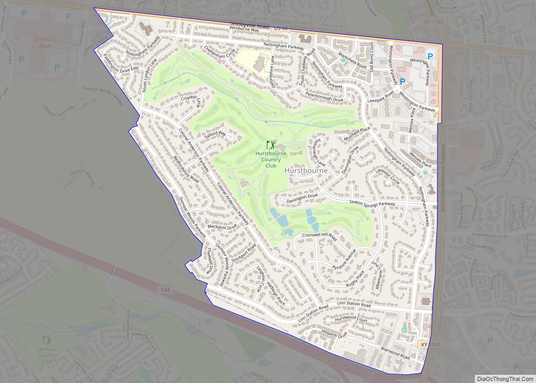
Hurstbourne is a home rule-class city in Jefferson County, Kentucky, United States. The population was 4,216 at the 2010 census, up from 3,884 at the time of the 2000 U.S. census. It is part of the Louisville Metro Government. Hurstbourne city overview: Name: Hurstbourne city LSAD Code: 25 LSAD Description: city (suffix) State: Kentucky County: … Read more

Map of Inez city

Map of Inez city, Kentucky

Inez (/ˈaɪnəz/ EYE-nəz) is a home rule-class city in and the county seat of Martin County, Kentucky, United States. The population was 546 at the 2020 census. Inez city overview: Name: Inez city LSAD Code: 25 LSAD Description: city (suffix) State: Kentucky County: Martin County Incorporated: February 5, 1942 Elevation: 636 ft (194 m) Total Area: 1.72 sq mi … Read more

Map of Indian Hills city, Kentucky

Map of Indian Hills city, Kentucky

Indian Hills is a home rule-class city along the Ohio River in Jefferson County, Kentucky, United States. The population was 2,860 as of the 2020 census. Indian Hills and the nearby cities of Mockingbird Valley, Glenview, and Anchorage have been cited as Louisville’s most prosperous suburbs since the mid-20th century. Indian Hills was among the … Read more

Map of Independence city, Kentucky

Map of Independence city, Kentucky

Independence is a home rule-class city in Kenton County, Kentucky, in the United States. It is one of its county’s two seats of government. The population was 24,757 at the time of the 2010 U.S. census, up from 14,982 at the 2000 census. It is the third largest city in Northern Kentucky after Covington and … Read more

Map of Irvington city, Kentucky

Map of Irvington city, Kentucky

Irvington is a home rule-class city in Breckinridge County, Kentucky, in the United States. The population was 1,181 at the 2010 census. Irvington city overview: Name: Irvington city LSAD Code: 25 LSAD Description: city (suffix) State: Kentucky County: Breckinridge County Incorporated: 1889 Elevation: 620 ft (189 m) Total Area: 0.88 sq mi (2.27 km²) Land Area: 0.88 sq mi (2.27 km²) Water Area: … Read more

Map of Irvine city, Kentucky

Map of Irvine city, Kentucky

Irvine (locally /ˈɜːrvən, ˈɜːrvaɪn/) is a home rule-class city in Estill County, Kentucky, in the United States. It is the seat of its county. Its population was 2,715 at the time of the 2010 census. Irvine city overview: Name: Irvine city LSAD Code: 25 LSAD Description: city (suffix) State: Kentucky County: Estill County Elevation: 679 ft … Read more

Map of Ironville CDP

Map of Ironville CDP

Ironville is an unincorporated community in Boyd County, Kentucky, United States, near the intersection of Kentucky Route 5 and Kentucky Route 766. Due to its proximity to Ashland, Ironville is often considered to be a part of Ashland, although officially it is separate from the city and serves as a suburb to the city. It … Read more

Map of Jamestown city, Kentucky

Map of Jamestown city, Kentucky

Jamestown is a home rule-class city in Russell County, Kentucky, in the United States. It is the seat of its county. The population was 1,794 at the 2010 U.S. census. Jamestown city overview: Name: Jamestown city LSAD Code: 25 LSAD Description: city (suffix) State: Kentucky County: Russell County Incorporated: 1826 Elevation: 971 ft (296 m) Total Area: … Read more

Map of Jackson city, Kentucky

Map of Jackson city, Kentucky

Jackson is a home rule-class city in and the county seat of Breathitt County, Kentucky, in the United States. The population was 2,231 according to the 2010 U.S. census. It was the home of the Jackson Academy, which became Lees College. Jackson city overview: Name: Jackson city LSAD Code: 25 LSAD Description: city (suffix) State: … Read more

Map of Island city

Map of Island city

Island is a home rule-class city in McLean County, Kentucky, in the United States. The population was 429 at the 2020 census. It is included in the Owensboro metropolitan area. Island city overview: Name: Island city LSAD Code: 25 LSAD Description: city (suffix) State: Kentucky County: McLean County Incorporated: Before 1908 Elevation: 449 ft (137 m) Total … Read more

Map of Jeff CDP

Map of Jeff CDP

Jeff is a census-designated place and coal town in Perry County, Kentucky, United States. Its population was 323 as of the 2010 census. A post office was established in the community in 1902 and named for the early settler Jefferson Combs. Jeff CDP overview: Name: Jeff CDP LSAD Code: 57 LSAD Description: CDP (suffix) State: … Read more

Map of Jeffersontown city

Map of Jeffersontown city

Jeffersontown is a home rule-class city in Jefferson County, Kentucky, United States. The population was 26,595 at the 2010 U.S. census. It is a major suburb of Louisville. When the Louisville Metro government was established in 2003, Jeffersontown chose to retain its status as an independent city. It is the metro area’s largest municipality outside … Read more