Map of Nicholasville city

Map of Nicholasville city

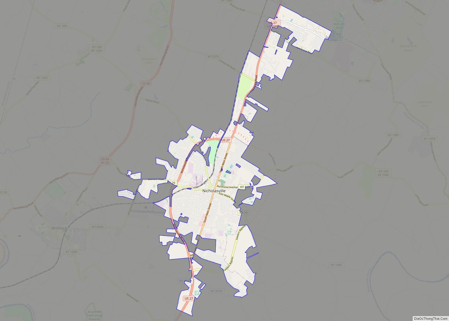
Nicholasville is a home rule city in and the county seat of Jessamine County, Kentucky. The population was 31,490 during the 2020 U.S. census, making Nicholasville the 10th-largest settlement in the state. Since the late 20th century, Nicholasville has undergone rapid growth; the population increased 440.23% between 1970 and 2020. The city serves as both … Read more

Map of Nortonville city, Kentucky

Map of Nortonville city, Kentucky

Nortonville is a home rule-class city in Hopkins County, Kentucky, in the United States. The population was 1,204 as of the 2010 census. Nortonville city overview: Name: Nortonville city LSAD Code: 25 LSAD Description: city (suffix) State: Kentucky County: Hopkins County Incorporated: 1873 Elevation: 404 ft (123 m) Total Area: 1.19 sq mi (3.09 km²) Land Area: 1.16 sq mi (3.00 km²) Water … Read more

Map of Northfield city, Kentucky

Map of Northfield city, Kentucky

Northfield is a home rule-class city in Jefferson County, Kentucky, United States. The population was 1,020 at the 2010 census. Northfield city overview: Name: Northfield city LSAD Code: 25 LSAD Description: city (suffix) State: Kentucky County: Jefferson County Incorporated: 1965 Elevation: 584 ft (178 m) Total Area: 0.47 sq mi (1.22 km²) Land Area: 0.47 sq mi (1.22 km²) Water Area: 0.00 sq mi (0.00 km²) … Read more

Map of North Middletown city

Map of North Middletown city, Kentucky

North Middletown is a home rule-class city in Bourbon County, Kentucky, in the United States. The population was 643 as of the 2010 census. North Middletown is part of the Lexington-Fayette Metropolitan Statistical Area. North Middletown city overview: Name: North Middletown city LSAD Code: 25 LSAD Description: city (suffix) State: Kentucky County: Bourbon County Incorporated: … Read more

Map of Oakbrook CDP

Map of Oakbrook CDP

Oakbrook is a census-designated place (CDP) in Boone County, Kentucky, United States. The population was 9,036 at the 2010 census. Oakbrook CDP overview: Name: Oakbrook CDP LSAD Code: 57 LSAD Description: CDP (suffix) State: Kentucky County: Boone County Elevation: 869 ft (265 m) Total Area: 3.20 sq mi (8.29 km²) Land Area: 3.20 sq mi (8.28 km²) Water Area: 0.00 sq mi (0.01 km²) Total Population: … Read more

Map of Oak Grove city, Kentucky

Map of Oak Grove city, Kentucky

Oak Grove is a home rule-class city adjacent to the Fort Campbell army base in Christian County, Kentucky, in the United States. The population was 7,489 as of the 2010 U.S. Census. It is part of the Clarksville, Tennessee metropolitan area. Oak Grove city overview: Name: Oak Grove city LSAD Code: 25 LSAD Description: city … Read more

Map of Norwood city, Kentucky

Map of Norwood city, Kentucky

Norwood is a home rule-class city in Jefferson County, Kentucky, United States. The population was 370 at the 2010 census. Norwood city overview: Name: Norwood city LSAD Code: 25 LSAD Description: city (suffix) State: Kentucky County: Jefferson County Incorporated: 1975 Elevation: 551 ft (168 m) Total Area: 0.12 sq mi (0.30 km²) Land Area: 0.12 sq mi (0.30 km²) Water Area: 0.00 sq mi (0.00 km²) … Read more

Map of Olive Hill city

Map of Olive Hill city

Olive Hill is a home rule-class city along Tygarts Creek in Carter County, Kentucky, in the United States. The population was 1,599 during the year 2010 U.S. Census. Olive Hill city overview: Name: Olive Hill city LSAD Code: 25 LSAD Description: city (suffix) State: Kentucky County: Carter County Incorporated: March 24, 1884 Elevation: 748 ft (228 m) … Read more

Map of Old Brownsboro Place city

Map of Old Brownsboro Place city

Old Brownsboro Place is a home rule-class city in Jefferson County, Kentucky, United States, and a part of the united Metro government. The population was 353 at the 2010 census. Old Brownsboro Place city overview: Name: Old Brownsboro Place city LSAD Code: 25 LSAD Description: city (suffix) State: Kentucky County: Jefferson County Incorporated: 1977 Elevation: … Read more

Map of Oakland city, Kentucky

Map of Oakland city, Kentucky

Oakland is a home rule-class city in Warren County, Kentucky, in the United States. The population was 260 during the year 2000 U.S. Census. It is included in the Bowling Green metropolitan area. Oakland city overview: Name: Oakland city LSAD Code: 25 LSAD Description: city (suffix) State: Kentucky County: Warren County Incorporated: 1977 Elevation: 584 ft … Read more

Map of Orchard Grass Hills city

Map of Orchard Grass Hills city

Orchard Grass Hills is a home rule-class city in Oldham County, Kentucky, in the United States. The population was 1,595 at the 2010 census. Orchard Grass Hills city overview: Name: Orchard Grass Hills city LSAD Code: 25 LSAD Description: city (suffix) State: Kentucky County: Oldham County Incorporated: 1979 Elevation: 630 ft (190 m) Total Area: 0.39 sq mi (1.01 km²) … Read more

Map of Onton CDP

Map of Onton CDP

Onton (/ˈɒntən/) is a census-designated place (CDP) in Webster County, Kentucky, United States. Onton CDP overview: Name: Onton CDP LSAD Code: 57 LSAD Description: CDP (suffix) State: Kentucky County: Webster County Elevation: 476 ft (145 m) Total Area: 0.83 sq mi (2.15 km²) Land Area: 0.82 sq mi (2.14 km²) Water Area: 0.00 sq mi (0.01 km²) Total Population: 138 Population Density: 167.27/sq mi (64.58/km²) FIPS code: … Read more