Map of Pryorsburg CDP

Map of Pryorsburg CDP

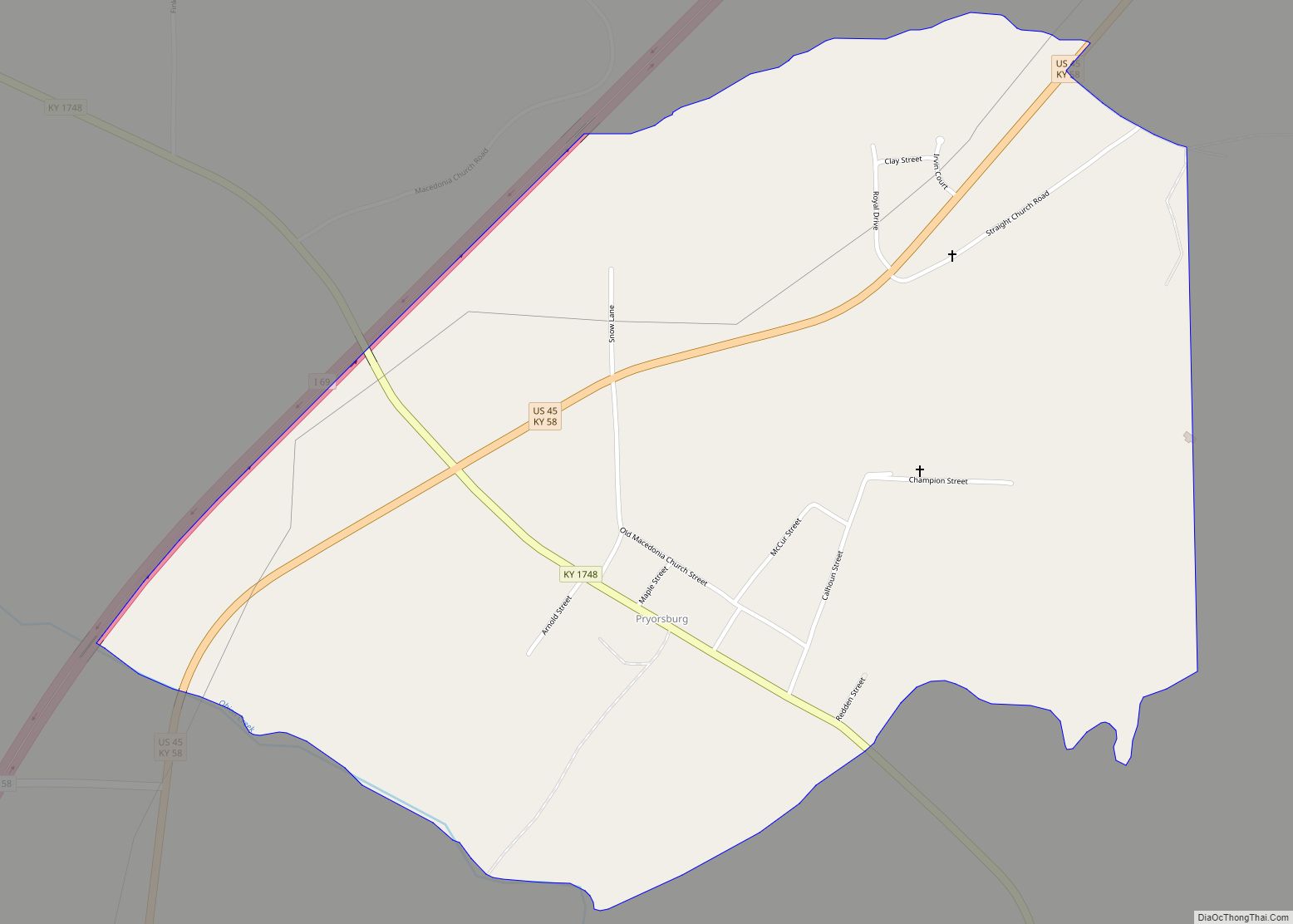
Pryorsburg (also Pryors) is an unincorporated community and census-designated place (CDP) in Graves County, Kentucky, United States. As of the 2010 census the population was 311. The community is located along U.S. Route 45, 6 miles (10 km) southwest of Mayfield, the county seat. Pryorsburg CDP overview: Name: Pryorsburg CDP LSAD Code: 57 LSAD Description: CDP … Read more

Map of Raywick city

Map of Raywick city

Raywick is a home rule-class city in Marion County, Kentucky, United States. The population was 155 at the 2020 census. Raywick city overview: Name: Raywick city LSAD Code: 25 LSAD Description: city (suffix) State: Kentucky County: Marion County Elevation: 607 ft (185 m) Total Area: 0.92 sq mi (2.37 km²) Land Area: 0.90 sq mi (2.32 km²) Water Area: 0.02 sq mi (0.05 km²) Total Population: … Read more

Map of Ravenna city

Map of Ravenna city, Kentucky

Ravenna is a home rule-class city in Estill County, Kentucky, United States. The population was 605 at the 2010 census. Ravenna city overview: Name: Ravenna city LSAD Code: 25 LSAD Description: city (suffix) State: Kentucky County: Estill County Elevation: 636 ft (194 m) Total Area: 0.31 sq mi (0.81 km²) Land Area: 0.31 sq mi (0.81 km²) Water Area: 0.00 sq mi (0.00 km²) Total Population: … Read more

Map of Radcliff city

Map of Radcliff city

Radcliff is a home rule-class city in Hardin County, Kentucky, in the United States. The population was 21,692 at the 2010 census, and in 2019 the estimated population was 22,914. It is included in the Elizabethtown–Fort Knox Metropolitan Area. Its economy is largely dominated by the adjacent U.S. Army base Fort Knox and by the … Read more

Map of Richmond city, Kentucky

Map of Richmond city, Kentucky

Richmond is a home rule-class city in and the county seat of Madison County, Kentucky, United States. It is named after Richmond, Virginia, and is home to Eastern Kentucky University. The population was 34,585 at the 2020 census. Richmond is the fourth-largest city in the Bluegrass region (after Louisville, Lexington and Georgetown) and the state’s … Read more

Map of Richlawn city

Map of Richlawn city

Richlawn is a home rule-class city in eastern Jefferson County, Kentucky, United States. The population was 415 at the 2020 United States Census. The population was 405 at the 2010 census, down from 454 at the 2000 census. It is surrounded by the larger city of St. Matthews. Richlawn city overview: Name: Richlawn city LSAD … Read more

Map of Reidland CDP

Map of Reidland CDP

Reidland is an unincorporated community and census-designated place (CDP) in McCracken County, Kentucky, United States. The population was 4,526 at the 2020 census. It is part of the Paducah, KY-IL Micropolitan Statistical Area. Reidland CDP overview: Name: Reidland CDP LSAD Code: 57 LSAD Description: CDP (suffix) State: Kentucky County: McCracken County Elevation: 404 ft (123 m) Total … Read more

Map of Riverwood city

Map of Riverwood city

Riverwood is a home rule-class city in northeastern Jefferson County, Kentucky, United States. The population was 446 at the 2010 census. Riverwood city overview: Name: Riverwood city LSAD Code: 25 LSAD Description: city (suffix) State: Kentucky County: Jefferson County Elevation: 551 ft (168 m) Total Area: 0.21 sq mi (0.54 km²) Land Area: 0.21 sq mi (0.54 km²) Water Area: 0.00 sq mi (0.00 km²) Total … Read more

Map of River Bluff city

Map of River Bluff city

River Bluff is a home rule-class city in Oldham County, Kentucky, United States. The population was 403 at the 2010 census. River Bluff city overview: Name: River Bluff city LSAD Code: 25 LSAD Description: city (suffix) State: Kentucky County: Oldham County Elevation: 636 ft (194 m) Total Area: 0.24 sq mi (0.61 km²) Land Area: 0.24 sq mi (0.61 km²) Water Area: 0.00 sq mi … Read more

Map of Rineyville CDP

Map of Rineyville CDP

Rineyville is an unincorporated community and census-designated place (CDP) in Hardin County, Kentucky, United States. It is located 7 miles (11 km) northwest of Elizabethtown. The Paducah and Louisville Railway runs north and south through the community. There is no formal city government; a Magistrate, elected to the Hardin County Fiscal Court, represents the unincorporated community. … Read more

Map of Robards city

Map of Robards city

Robards (/ˈrɒbərdz/) is a home rule-class city in Henderson County, Kentucky, United States. The population was 515 at the 2010 census, down from 564 at the 2000 census. Robards city overview: Name: Robards city LSAD Code: 25 LSAD Description: city (suffix) State: Kentucky County: Henderson County Elevation: 430 ft (131 m) Total Area: 3.04 sq mi (7.88 km²) Land Area: … Read more

Map of Rockholds CDP

Map of Rockholds CDP

Rockholds is an unincorporated community and census-designated place in Whitley County, Kentucky, United States. Rockholds CDP overview: Name: Rockholds CDP LSAD Code: 57 LSAD Description: CDP (suffix) State: Kentucky County: Whitley County Elevation: 984 ft (300 m) Total Area: 1.19 sq mi (3.08 km²) Land Area: 1.19 sq mi (3.07 km²) Water Area: 0.00 sq mi (0.01 km²) Total Population: 330 Population Density: 278.25/sq mi (107.39/km²) ZIP … Read more