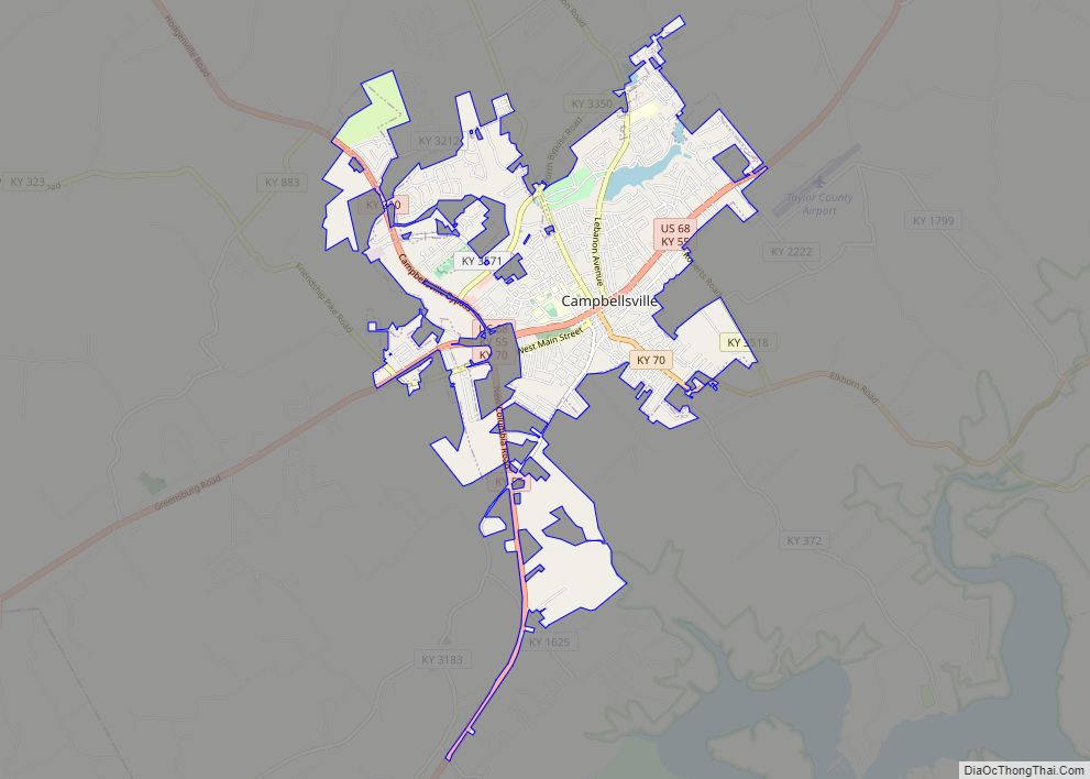
Map of Cambridge city, Kentucky

Map of Cambridge city, Kentucky

Cambridge is a home rule-class city in Jefferson County, Kentucky, United States. The population was 175 at the 2010 census. Cambridge city overview: Name: Cambridge city LSAD Code: 25 LSAD Description: city (suffix) State: Kentucky County: Jefferson County Elevation: 584 ft (178 m) Total Area: 0.06 sq mi (0.14 km²) Land Area: 0.06 sq mi (0.14 km²) Water Area: 0.00 sq mi (0.00 km²) Total Population: … Read more

Map of Caneyville city

Map of Caneyville city

Caneyville is a home rule-class city in Grayson County, Kentucky, in the United States. The population was 608 at the 2010 census. Named for its location on Caney Creek, Caneyville had a post office by 1837 and a town charter by 1840 and was incorporated by the state legislature in 1880. Caneyville city overview: Name: … Read more

Map of Campton city

Map of Campton city

Campton is a home rule-class city in and the county seat of Wolfe County, Kentucky, United States. The population was 441 at the 2010 census. Campton city overview: Name: Campton city LSAD Code: 25 LSAD Description: city (suffix) State: Kentucky County: Wolfe County Incorporated: March 17, 1870 Elevation: 961 ft (293 m) Total Area: 1.00 sq mi (2.59 km²) Land … Read more

Map of Cannonsburg CDP

Map of Cannonsburg CDP

Cannonsburg is a census-designated place (CDP) in Boyd County, Kentucky, United States. As of the 2010 census, it had a population of 856. Cannonsburg is located 8 miles (13 km) southwest of the city of Ashland, a major urban center in northeastern Kentucky. Most of Cannonsburg shares its ZIP code with Ashland; however, parts are within … Read more

Map of Carrsville city

Map of Carrsville city, Kentucky

Carrsville is a home rule-class city beside the Ohio River in Livingston County, Kentucky, in the United States. The population was 50 at the 2010 census, declining from 64 as of 2000. It is part of the Paducah, KY-IL Micropolitan Statistical Area. It is situated just west of the junction of where Buck Creek empties … Read more

Map of Carrollton city, Kentucky

Map of Carrollton city, Kentucky

Carrollton is a home rule-class city in—and the county seat of—Carroll County, Kentucky, United States, at the confluence of the Ohio and Kentucky rivers. The population was 3,938 at the 2010 census. Carrollton city overview: Name: Carrollton city LSAD Code: 25 LSAD Description: city (suffix) State: Kentucky County: Carroll County Elevation: 482 ft (147 m) Total Area: … Read more

Map of Carlisle city, Kentucky

Map of Carlisle city, Kentucky

Carlisle is a home rule-class city in Nicholas County, Kentucky, United States. The population was 2,010 at the 2010 census. It is the county seat of Nicholas County. It is located at the junction of Kentucky Route 32 and Kentucky Route 36, about halfway between Lexington and Maysville. Carlisle city overview: Name: Carlisle city LSAD … Read more

Map of Cawood CDP

Map of Cawood CDP

Cawood is a census-designated place (CDP) and coal town in Harlan County, Kentucky, United States. The population was 731 at the 2010 census. A post office in Cawood was established in 1890 by Wilson S. Hensley. He said one of his ancestors was Berry Cawood, a hero of the Revolutionary War. Cawood CDP overview: Name: … Read more

Map of Cave City, Kentucky

Map of Cave City, Kentucky

Cave City is a home rule-class city in Barren County, Kentucky, in the United States. The population was 2,240 at the 2010 census. It is part of the Glasgow Micropolitan Statistical Area. Cave City overview: Name: Cave City LSAD Code: 25 LSAD Description: city (suffix) State: Kentucky County: Barren County Elevation: 633 ft (193 m) Total Area: … Read more

Map of Catlettsburg city

Map of Catlettsburg city

Catlettsburg is a home rule-class city in and the county seat of Boyd County, Kentucky, United States. The city population was 1,780 at the 2020 census. It is part of the Huntington–Ashland metropolitan area. Catlettsburg city overview: Name: Catlettsburg city LSAD Code: 25 LSAD Description: city (suffix) State: Kentucky County: Boyd County Elevation: 554 ft (169 m) … Read more

Map of Centertown city

Map of Centertown city, Kentucky

Centertown is a home rule-class city in Ohio County, Kentucky, in the United States. The population was 423 at the 2010 census. Centertown city overview: Name: Centertown city LSAD Code: 25 LSAD Description: city (suffix) State: Kentucky County: Ohio County Elevation: 443 ft (135 m) Total Area: 0.31 sq mi (0.81 km²) Land Area: 0.31 sq mi (0.81 km²) Water Area: 0.00 sq mi (0.00 km²) … Read more

Map of Cecilia CDP

Map of Cecilia CDP, Kentucky

Cecilia is a census-designated place (CDP) and unincorporated community in Hardin County, Kentucky, United States. It is located 6 miles (10 km) west of Elizabethtown, the county seat. As of the 2010 census it had a population of 572. The town was formerly called “Cecilian Junction” because of its location at the junction of the Illinois … Read more